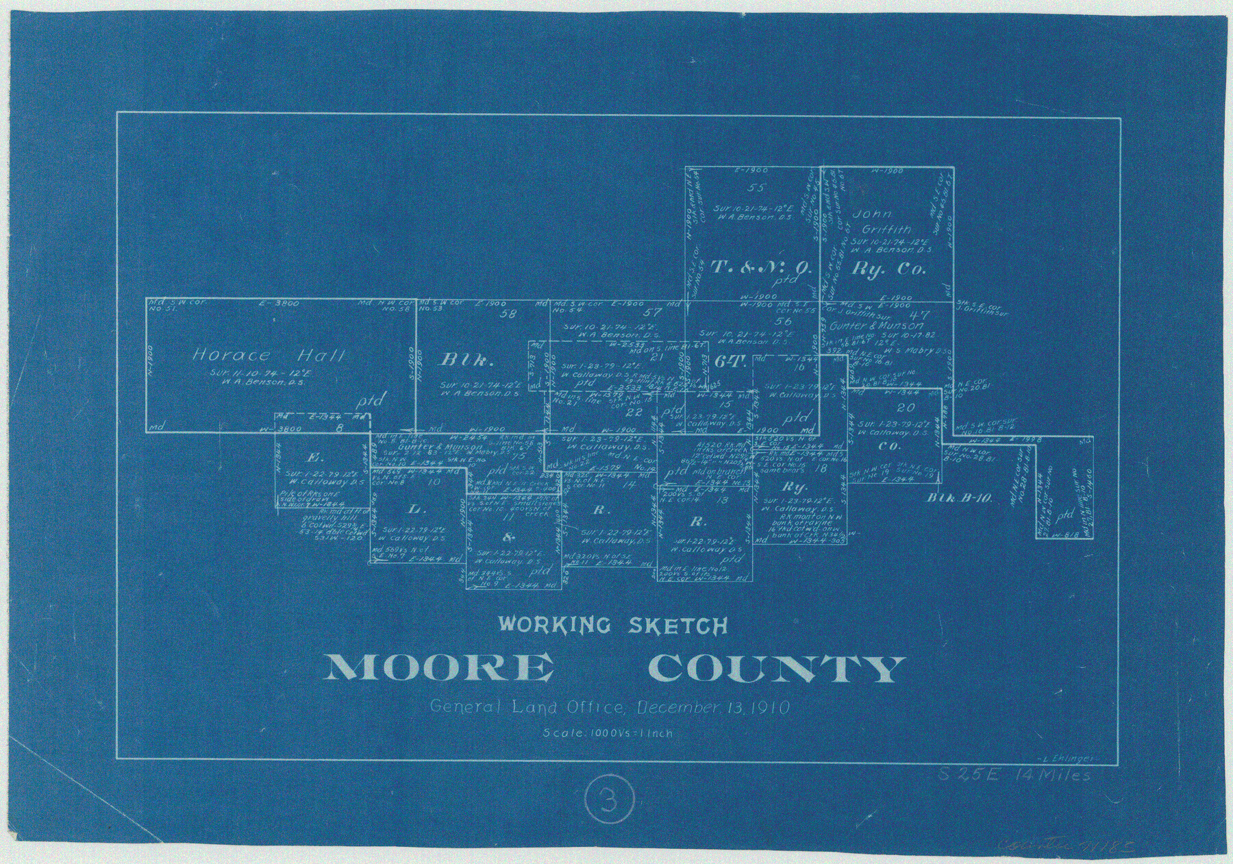
Moore County Working Sketch 3
-
Map/Doc
71185
-
Collection
General Map Collection
-
Object Dates
12/13/1910 (Creation Date)
-
People and Organizations
L. Ehlinger (Draftsman)
-
Counties
Moore
-
Subjects
Surveying Working Sketch
-
Height x Width
12.2 x 17.4 inches
31.0 x 44.2 cm
-
Scale
1" = 1000 varas
Part of: General Map Collection
Map of Nacogdoches County

Print $20.00
- Digital $50.00
Map of Nacogdoches County
1881
Size 24.1 x 21.5 inches
Map/Doc 4605
[Sketch for Mineral Application 16696-16697, Pecos River]
![76024, [Sketch for Mineral Application 16696-16697, Pecos River], General Map Collection](https://historictexasmaps.com/wmedia_w700/maps/76024.tif.jpg)
Print $40.00
- Digital $50.00
[Sketch for Mineral Application 16696-16697, Pecos River]
Size 44.0 x 126.6 inches
Map/Doc 76024
Map of the River Sabine from its mouth on the Gulf of Mexico in the Sea to Logan's Ferry in Latitude 31°58'24" North

Print $40.00
- Digital $50.00
Map of the River Sabine from its mouth on the Gulf of Mexico in the Sea to Logan's Ferry in Latitude 31°58'24" North
1842
Size 173.2 x 31.0 inches
Map/Doc 1744
Newton County Sketch File 37

Print $6.00
- Digital $50.00
Newton County Sketch File 37
Size 16.2 x 10.7 inches
Map/Doc 32415
United States - Gulf Coast - From Latitude 26° 33' to the Rio Grande Texas

Print $20.00
- Digital $50.00
United States - Gulf Coast - From Latitude 26° 33' to the Rio Grande Texas
1913
Size 18.4 x 27.9 inches
Map/Doc 72842
Montague County Working Sketch 19

Print $20.00
- Digital $50.00
Montague County Working Sketch 19
1952
Size 26.4 x 21.5 inches
Map/Doc 71085
Runnels County Sketch File 21A

Print $20.00
Runnels County Sketch File 21A
1886
Size 17.5 x 20.5 inches
Map/Doc 12256
Hutchinson County Working Sketch 34

Print $20.00
- Digital $50.00
Hutchinson County Working Sketch 34
1978
Size 27.0 x 22.9 inches
Map/Doc 66394
Amistad International Reservoir on Rio Grande 82

Print $20.00
- Digital $50.00
Amistad International Reservoir on Rio Grande 82
1949
Size 28.5 x 40.2 inches
Map/Doc 75511
Refugio County Boundary File 1 (3)

Print $22.00
- Digital $50.00
Refugio County Boundary File 1 (3)
Size 10.4 x 27.5 inches
Map/Doc 58231

[F. W. & D. C. Ry. Co. Alignment and Right of Way Map, Clay County]
![64737, [F. W. & D. C. Ry. Co. Alignment and Right of Way Map, Clay County], General Map Collection](https://historictexasmaps.com/wmedia_w700/maps/64737-GC.tif.jpg)
Print $20.00
- Digital $50.00
[F. W. & D. C. Ry. Co. Alignment and Right of Way Map, Clay County]
1927
Size 18.6 x 11.8 inches
Map/Doc 64737
You may also like
Hill County Sketch File 24

Print $40.00
- Digital $50.00
Hill County Sketch File 24
Size 15.6 x 13.8 inches
Map/Doc 26516
Houston County Sketch File 4a

Print $4.00
- Digital $50.00
Houston County Sketch File 4a
1858
Size 13.0 x 8.3 inches
Map/Doc 26754
Right of Way and Track Map, The Missouri, Kansas and Texas Ry. of Texas operated by the Missouri, Kansas and Texas Ry. of Texas, Henrietta Division

Print $40.00
- Digital $50.00
Right of Way and Track Map, The Missouri, Kansas and Texas Ry. of Texas operated by the Missouri, Kansas and Texas Ry. of Texas, Henrietta Division
1918
Size 25.5 x 56.6 inches
Map/Doc 64070
Right of Way and Track Map, Galveston, Harrisburg & San Antonio Ry. operated by the T. & N. O. R.R. Co., Victoria Division, Rosenberg to Beeville

Print $40.00
- Digital $50.00
Right of Way and Track Map, Galveston, Harrisburg & San Antonio Ry. operated by the T. & N. O. R.R. Co., Victoria Division, Rosenberg to Beeville
1918
Size 25.4 x 57.5 inches
Map/Doc 76160
General Highway Map, Chambers County, Texas

Print $20.00
General Highway Map, Chambers County, Texas
1961
Size 18.3 x 24.8 inches
Map/Doc 79404
Presidio County Rolled Sketch 123

Print $40.00
- Digital $50.00
Presidio County Rolled Sketch 123
Size 49.3 x 38.2 inches
Map/Doc 9798
Gregg County Sketch File 5

Print $6.00
- Digital $50.00
Gregg County Sketch File 5
1931
Size 11.2 x 8.7 inches
Map/Doc 24574
Dallas County Sketch File 15

Print $10.00
- Digital $50.00
Dallas County Sketch File 15
1863
Size 11.5 x 8.5 inches
Map/Doc 20430
Flight Mission No. BQR-4K, Frame 59, Brazoria County

Print $20.00
- Digital $50.00
Flight Mission No. BQR-4K, Frame 59, Brazoria County
1952
Size 18.7 x 22.4 inches
Map/Doc 83992
The Newest Land Of Promise - The Pecos Valley in Texas

Print $20.00
- Digital $50.00
The Newest Land Of Promise - The Pecos Valley in Texas
1900
Size 17.8 x 22.8 inches
Map/Doc 97037
Fannin County Sketch File 13

Print $4.00
- Digital $50.00
Fannin County Sketch File 13
Size 8.1 x 7.9 inches
Map/Doc 22462
Flight Mission No. CLL-1N, Frame 21, Willacy County

Print $20.00
- Digital $50.00
Flight Mission No. CLL-1N, Frame 21, Willacy County
1954
Size 18.7 x 22.3 inches
Map/Doc 87008