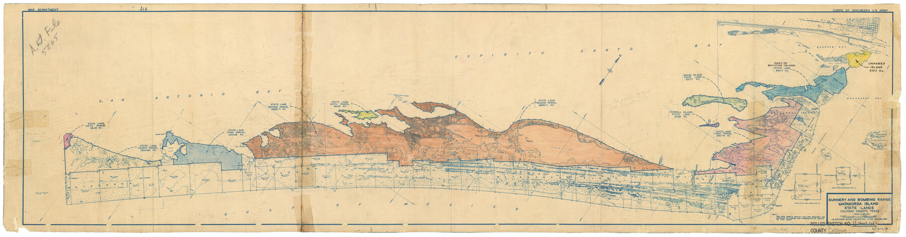
Calhoun County Rolled Sketch 11
Gunnery and Bombing Range, Matagorda Island, State Lands, Calhoun County, Texas
-
Map/Doc
5367
-
Collection
General Map Collection
-
Object Dates
7/25/1942 (Creation Date)
-
Counties
Calhoun
-
Subjects
Surveying Rolled Sketch Military
-
Height x Width
10.6 x 40.7 inches
26.9 x 103.4 cm
-
Medium
blueprint/diazo
-
Comments
See Calhoun County Sketch File 6 (35908) for field notes.
Related maps
Calhoun County Sketch File 6

Print $34.00
- Digital $50.00
Calhoun County Sketch File 6
1942
Size 9.3 x 9.0 inches
Map/Doc 35908
Calhoun County Rolled Sketch 11

Print $20.00
- Digital $50.00
Calhoun County Rolled Sketch 11
1942
Size 12.8 x 41.9 inches
Map/Doc 5368
Calhoun County Rolled Sketch 11

Print $3.00
- Digital $50.00
Calhoun County Rolled Sketch 11
1942
Size 10.9 x 16.2 inches
Map/Doc 5462
Calhoun County Rolled Sketch 11

Print $3.00
- Digital $50.00
Calhoun County Rolled Sketch 11
1942
Size 10.9 x 16.2 inches
Map/Doc 5463
Calhoun County Rolled Sketch 11

Print $3.00
- Digital $50.00
Calhoun County Rolled Sketch 11
1942
Size 10.8 x 16.3 inches
Map/Doc 5464
Part of: General Map Collection
Hamilton County Sketch File 4

Print $16.00
- Digital $50.00
Hamilton County Sketch File 4
Size 14.5 x 9.1 inches
Map/Doc 24903
Donley County Working Sketch 2

Print $20.00
- Digital $50.00
Donley County Working Sketch 2
1916
Size 15.2 x 17.1 inches
Map/Doc 68735
Flight Mission No. CRE-2R, Frame 155, Jackson County

Print $20.00
- Digital $50.00
Flight Mission No. CRE-2R, Frame 155, Jackson County
1956
Size 16.1 x 16.1 inches
Map/Doc 85366
Flight Mission No. CRC-4R, Frame 65, Chambers County

Print $20.00
- Digital $50.00
Flight Mission No. CRC-4R, Frame 65, Chambers County
1956
Size 18.6 x 22.4 inches
Map/Doc 84869
Hudspeth County Rolled Sketch 69

Print $20.00
- Digital $50.00
Hudspeth County Rolled Sketch 69
1973
Size 13.3 x 20.5 inches
Map/Doc 7716
Brewster County Rolled Sketch 143

Print $20.00
- Digital $50.00
Brewster County Rolled Sketch 143
1985
Size 18.3 x 28.0 inches
Map/Doc 5311
Chambers County Rolled Sketch 7

Print $20.00
- Digital $50.00
Chambers County Rolled Sketch 7
Size 39.8 x 23.1 inches
Map/Doc 8611
Real County Working Sketch 74

Print $20.00
- Digital $50.00
Real County Working Sketch 74
1979
Size 17.1 x 23.5 inches
Map/Doc 71966
Potter County Sketch File 15

Print $20.00
- Digital $50.00
Potter County Sketch File 15
Size 19.5 x 21.1 inches
Map/Doc 12201
Brooks County Sketch File 5

Print $18.00
- Digital $50.00
Brooks County Sketch File 5
1941
Size 11.3 x 9.0 inches
Map/Doc 16551
Oldham County Sketch File 6

Print $20.00
- Digital $50.00
Oldham County Sketch File 6
1883
Size 31.4 x 42.8 inches
Map/Doc 10561
Sketch J No. 2 Showing the Progress of the Survey of San Francisco Bay and Vicinity Section X From 1850 to 1852

Print $20.00
- Digital $50.00
Sketch J No. 2 Showing the Progress of the Survey of San Francisco Bay and Vicinity Section X From 1850 to 1852
1852
Size 12.3 x 12.7 inches
Map/Doc 97229
You may also like
Flight Mission No. CRE-1R, Frame 193, Jackson County

Print $20.00
- Digital $50.00
Flight Mission No. CRE-1R, Frame 193, Jackson County
1956
Size 18.5 x 22.2 inches
Map/Doc 85347
Roberts County Sketch File 9

Print $26.00
- Digital $50.00
Roberts County Sketch File 9
1992
Size 14.3 x 9.0 inches
Map/Doc 35327
[United States]
![97197, [United States], General Map Collection](https://historictexasmaps.com/wmedia_w700/maps/97197.tif.jpg)
Print $20.00
- Digital $50.00
[United States]
1848
Size 17.7 x 37.4 inches
Map/Doc 97197
Eastland County Working Sketch 53

Print $20.00
- Digital $50.00
Eastland County Working Sketch 53
1982
Size 22.9 x 27.4 inches
Map/Doc 68834
Montague County Working Sketch 30

Print $20.00
- Digital $50.00
Montague County Working Sketch 30
1974
Size 22.7 x 23.3 inches
Map/Doc 71096
Stephens County Working Sketch 5

Print $20.00
- Digital $50.00
Stephens County Working Sketch 5
1919
Size 24.8 x 25.3 inches
Map/Doc 63948
Map of the City of San Antonio, Bexar County, Texas including suburbs, north and south

Print $20.00
- Digital $50.00
Map of the City of San Antonio, Bexar County, Texas including suburbs, north and south
Size 39.6 x 26.6 inches
Map/Doc 96511
Ward County Rolled Sketch 24F

Print $40.00
- Digital $50.00
Ward County Rolled Sketch 24F
Size 30.5 x 65.2 inches
Map/Doc 78232
Collingsworth County Sketch File 6

Print $4.00
- Digital $50.00
Collingsworth County Sketch File 6
1896
Size 11.4 x 9.1 inches
Map/Doc 18882
A Geographically Correct Map of the State of Texas

Print $20.00
- Digital $50.00
A Geographically Correct Map of the State of Texas
1878
Size 19.5 x 21.0 inches
Map/Doc 95757
Treaty to Resolve Pending Boundary Differences and Maintain the Rio Grande and Colorado River as the International Boundary Between the United States of American and Mexico

Print $20.00
- Digital $50.00
Treaty to Resolve Pending Boundary Differences and Maintain the Rio Grande and Colorado River as the International Boundary Between the United States of American and Mexico
1970
Size 11.0 x 35.2 inches
Map/Doc 83105
Bandera County Sketch File 26

Print $6.00
- Digital $50.00
Bandera County Sketch File 26
1879
Size 7.7 x 8.3 inches
Map/Doc 14016