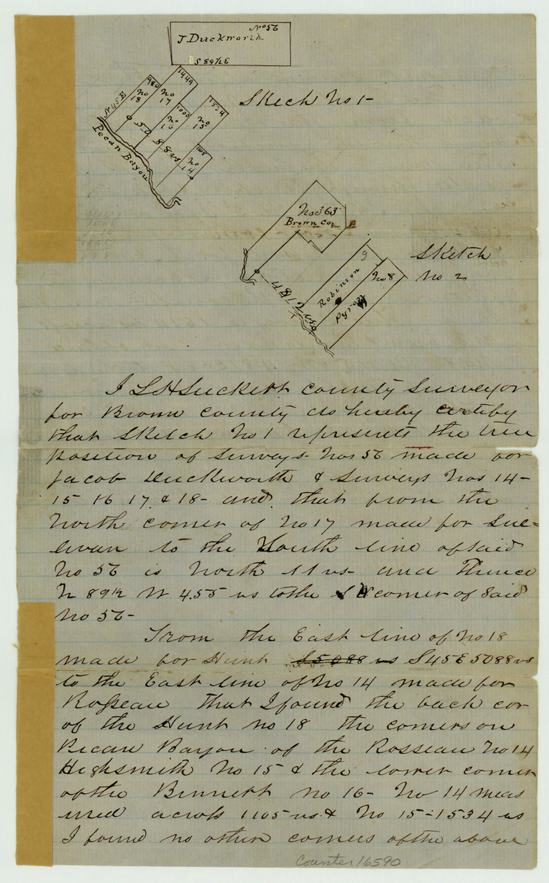
Brown County Sketch File 7
[Two sketches of areas on Pecan Bayou near and southeast from Brownwood]
-
Map/Doc
16590
-
Collection
General Map Collection
-
Object Dates
1860/4/2 (Creation Date)
1860/4/7 (File Date)
-
People and Organizations
L.H. Luckett (Surveyor/Engineer)
-
Counties
Brown
-
Subjects
Surveying Sketch File
-
Height x Width
13.0 x 8.1 inches
33.0 x 20.6 cm
-
Medium
paper, manuscript
-
Features
Pecan Bayou
Part of: General Map Collection
Pecos County Rolled Sketch 82

Print $20.00
- Digital $50.00
Pecos County Rolled Sketch 82
1930
Size 28.4 x 25.7 inches
Map/Doc 10190
Flight Mission No. DQN-3K, Frame 66, Calhoun County

Print $20.00
- Digital $50.00
Flight Mission No. DQN-3K, Frame 66, Calhoun County
1953
Size 18.7 x 22.5 inches
Map/Doc 84357
Hutchinson County Working Sketch 39

Print $20.00
- Digital $50.00
Hutchinson County Working Sketch 39
1978
Size 27.4 x 23.2 inches
Map/Doc 66399
Flight Mission No. CRK-5P, Frame 160, Refugio County

Print $20.00
- Digital $50.00
Flight Mission No. CRK-5P, Frame 160, Refugio County
1956
Size 18.6 x 22.4 inches
Map/Doc 86941
Cherokee County Working Sketch 23
Print $20.00
- Digital $50.00
Cherokee County Working Sketch 23
1972
Size 44.4 x 46.9 inches
Map/Doc 67978
San Jacinto River and Tributaries, Texas - Survey of 1939

Print $20.00
- Digital $50.00
San Jacinto River and Tributaries, Texas - Survey of 1939
1939
Size 28.1 x 40.5 inches
Map/Doc 3153
Jefferson County Sketch File 42

Print $20.00
- Digital $50.00
Jefferson County Sketch File 42
1945
Size 25.5 x 35.1 inches
Map/Doc 11876
[Surveys along the Guadalupe River and Blanco Creek]
![45, [Surveys along the Guadalupe River and Blanco Creek], General Map Collection](https://historictexasmaps.com/wmedia_w700/maps/45.tif.jpg)
Print $20.00
- Digital $50.00
[Surveys along the Guadalupe River and Blanco Creek]
Size 19.5 x 15.7 inches
Map/Doc 45
Kleberg County Rolled Sketch 12

Print $20.00
- Digital $50.00
Kleberg County Rolled Sketch 12
1994
Size 25.8 x 36.6 inches
Map/Doc 6553
Travis County Appraisal District Plat Map 2_1709

Print $20.00
- Digital $50.00
Travis County Appraisal District Plat Map 2_1709
Size 21.6 x 26.5 inches
Map/Doc 94210
Chambers County Sketch File 54

Print $3.00
- Digital $50.00
Chambers County Sketch File 54
1895
Size 16.5 x 10.3 inches
Map/Doc 18093

You may also like
Flight Mission No. CUG-3P, Frame 14, Kleberg County

Print $20.00
- Digital $50.00
Flight Mission No. CUG-3P, Frame 14, Kleberg County
1956
Size 18.7 x 22.3 inches
Map/Doc 86224
Stonewall County

Print $20.00
- Digital $50.00
Stonewall County
1879
Size 22.7 x 19.1 inches
Map/Doc 4058
Brazoria County Sketch File 28

Print $6.00
- Digital $50.00
Brazoria County Sketch File 28
1889
Size 8.8 x 14.2 inches
Map/Doc 15030
Mexico and Guatimala

Print $20.00
- Digital $50.00
Mexico and Guatimala
1828
Size 9.9 x 12.4 inches
Map/Doc 97276
Upton County Rolled Sketch 28

Print $20.00
- Digital $50.00
Upton County Rolled Sketch 28
Size 19.6 x 27.5 inches
Map/Doc 8075
Lampasas County Working Sketch 12

Print $20.00
- Digital $50.00
Lampasas County Working Sketch 12
1969
Size 32.9 x 31.4 inches
Map/Doc 70289
Hardeman County Sketch File 3

Print $8.00
- Digital $50.00
Hardeman County Sketch File 3
1880
Size 14.2 x 8.8 inches
Map/Doc 24987
[Surveys along the Leon River]
![82093, [Surveys along the Leon River], General Map Collection](https://historictexasmaps.com/wmedia_w700/maps/82093.tif.jpg)
Print $20.00
- Digital $50.00
[Surveys along the Leon River]
1840
Size 20.5 x 6.7 inches
Map/Doc 82093
Somervell County Working Sketch 3

Print $20.00
- Digital $50.00
Somervell County Working Sketch 3
1968
Size 23.0 x 30.4 inches
Map/Doc 63907
Childress County Sketch File 2

Print $24.00
- Digital $50.00
Childress County Sketch File 2
Size 6.5 x 16.1 inches
Map/Doc 18244
Birds-eye view of the camp of the army of occupation commanded by Genl. Taylor near Corpus Christi, Texas (from the North)

Print $20.00
- Digital $50.00
Birds-eye view of the camp of the army of occupation commanded by Genl. Taylor near Corpus Christi, Texas (from the North)
1847
Size 15.8 x 20.5 inches
Map/Doc 95951
Colorado County Sketch File 20

Print $6.00
- Digital $50.00
Colorado County Sketch File 20
Size 6.0 x 7.6 inches
Map/Doc 18954