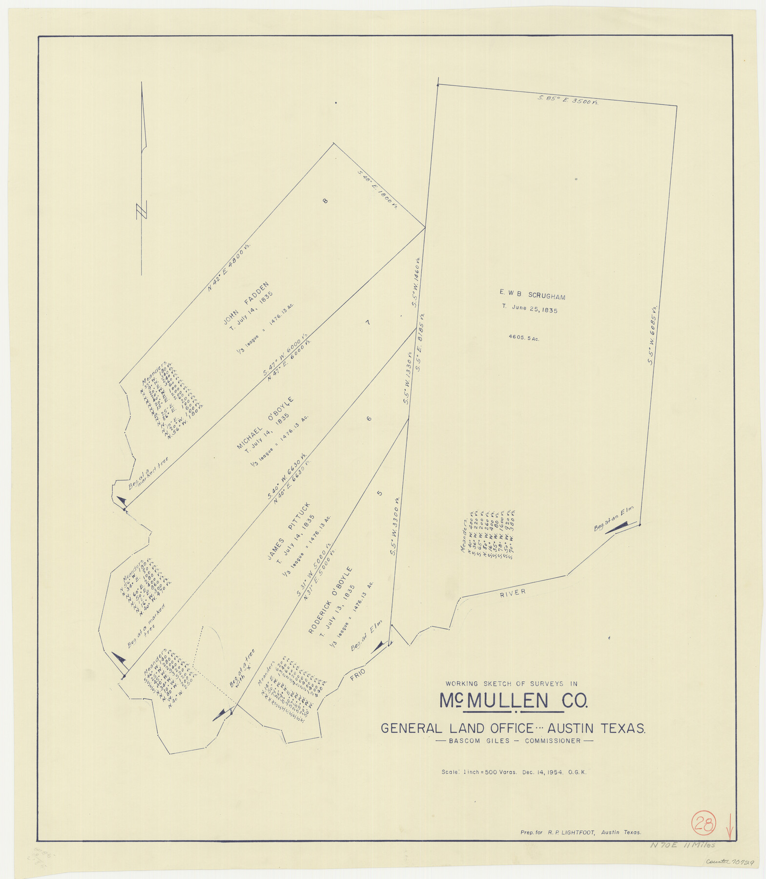
McMullen County Working Sketch 28
-
Map/Doc
70729
-
Collection
General Map Collection
-
Object Dates
12/14/1954 (Creation Date)
-
People and Organizations
Otto G. Kurio (Draftsman)
-
Counties
McMullen
-
Subjects
Surveying Working Sketch
-
Height x Width
25.6 x 22.4 inches
65.0 x 56.9 cm
-
Scale
1" = 500 varas
Part of: General Map Collection
Williamson County Working Sketch 14

Print $20.00
- Digital $50.00
Williamson County Working Sketch 14
1982
Size 22.0 x 28.3 inches
Map/Doc 72574
San Jacinto County Sketch File 23

Print $26.00
San Jacinto County Sketch File 23
1993
Size 14.6 x 8.8 inches
Map/Doc 35803
Brazoria County NRC Article 33.136 Sketch 26

Print $24.00
Brazoria County NRC Article 33.136 Sketch 26
2025
Map/Doc 97471
McMullen County Working Sketch 13

Print $20.00
- Digital $50.00
McMullen County Working Sketch 13
1938
Size 27.2 x 21.6 inches
Map/Doc 70714
Hutchinson County Rolled Sketch 21

Print $20.00
- Digital $50.00
Hutchinson County Rolled Sketch 21
Size 28.4 x 36.1 inches
Map/Doc 6286
Flight Mission No. DCL-7C, Frame 145, Kenedy County

Print $20.00
- Digital $50.00
Flight Mission No. DCL-7C, Frame 145, Kenedy County
1943
Size 18.6 x 22.5 inches
Map/Doc 86102
Bandera County

Print $40.00
- Digital $50.00
Bandera County
1947
Size 34.2 x 55.3 inches
Map/Doc 95424
Newton County Working Sketch 19

Print $20.00
- Digital $50.00
Newton County Working Sketch 19
1951
Size 28.7 x 23.4 inches
Map/Doc 71265
Orange County Aerial Photograph Index Sheet 1

Print $20.00
- Digital $50.00
Orange County Aerial Photograph Index Sheet 1
1957
Size 24.1 x 20.4 inches
Map/Doc 83740
Map of the Lands Surveyed by the Memphis, El Paso & Pacific R.R. Company

Print $20.00
- Digital $50.00
Map of the Lands Surveyed by the Memphis, El Paso & Pacific R.R. Company
1859
Size 13.9 x 21.3 inches
Map/Doc 4849
Cameron County Rolled Sketch 19

Print $2.00
- Digital $50.00
Cameron County Rolled Sketch 19
Size 7.0 x 5.6 inches
Map/Doc 5467
[Gulf, Colorado & Santa Fe]
![64576, [Gulf, Colorado & Santa Fe], General Map Collection](https://historictexasmaps.com/wmedia_w700/maps/64576.tif.jpg)
Print $40.00
- Digital $50.00
[Gulf, Colorado & Santa Fe]
Size 32.4 x 84.9 inches
Map/Doc 64576
You may also like
Controlled Mosaic by Jack Amman Photogrammetric Engineers, Inc - Sheet 46

Print $20.00
- Digital $50.00
Controlled Mosaic by Jack Amman Photogrammetric Engineers, Inc - Sheet 46
1954
Size 20.0 x 24.0 inches
Map/Doc 83505
Sabine County Working Sketch Graphic Index

Print $20.00
- Digital $50.00
Sabine County Working Sketch Graphic Index
1920
Size 42.4 x 33.1 inches
Map/Doc 76689
Bandera County Working Sketch 25

Print $20.00
- Digital $50.00
Bandera County Working Sketch 25
1950
Size 30.4 x 38.5 inches
Map/Doc 67621
A Geographically Correct County Map of States Traversed by the St. Louis, Iron Mountain and Southern Railway and its connections

Print $20.00
- Digital $50.00
A Geographically Correct County Map of States Traversed by the St. Louis, Iron Mountain and Southern Railway and its connections
1878
Size 16.9 x 27.0 inches
Map/Doc 95785
Map of Texas and the countries adjacent compiled in the Bureau of the Corps of Topographical Engineers from the best authorities for the State Department

Print $20.00
- Digital $50.00
Map of Texas and the countries adjacent compiled in the Bureau of the Corps of Topographical Engineers from the best authorities for the State Department
1844
Size 25.9 x 18.2 inches
Map/Doc 72714
Atascosa County Working Sketch 15

Print $40.00
- Digital $50.00
Atascosa County Working Sketch 15
1935
Size 43.8 x 53.6 inches
Map/Doc 67211
Parker County Sketch File 24

Print $4.00
- Digital $50.00
Parker County Sketch File 24
Size 8.6 x 13.0 inches
Map/Doc 33564
Lavaca County Working Sketch 26

Print $20.00
- Digital $50.00
Lavaca County Working Sketch 26
1986
Size 25.0 x 28.1 inches
Map/Doc 70379
[King/Stonewall County Line]
![90979, [King/Stonewall County Line], Twichell Survey Records](https://historictexasmaps.com/wmedia_w700/maps/90979-1.tif.jpg)
Print $20.00
- Digital $50.00
[King/Stonewall County Line]
1895
Size 38.9 x 8.3 inches
Map/Doc 90979
Culberson County Sketch File 21

Print $20.00
- Digital $50.00
Culberson County Sketch File 21
1937
Size 11.2 x 8.8 inches
Map/Doc 20224
Burleson County State Real Property Sketch 1

Print $80.00
- Digital $50.00
Burleson County State Real Property Sketch 1
2003
Size 37.0 x 53.6 inches
Map/Doc 81907
The Mexican Municipality of Gonzales. Proposed, No Date

Print $20.00
The Mexican Municipality of Gonzales. Proposed, No Date
2020
Size 20.4 x 21.7 inches
Map/Doc 96020