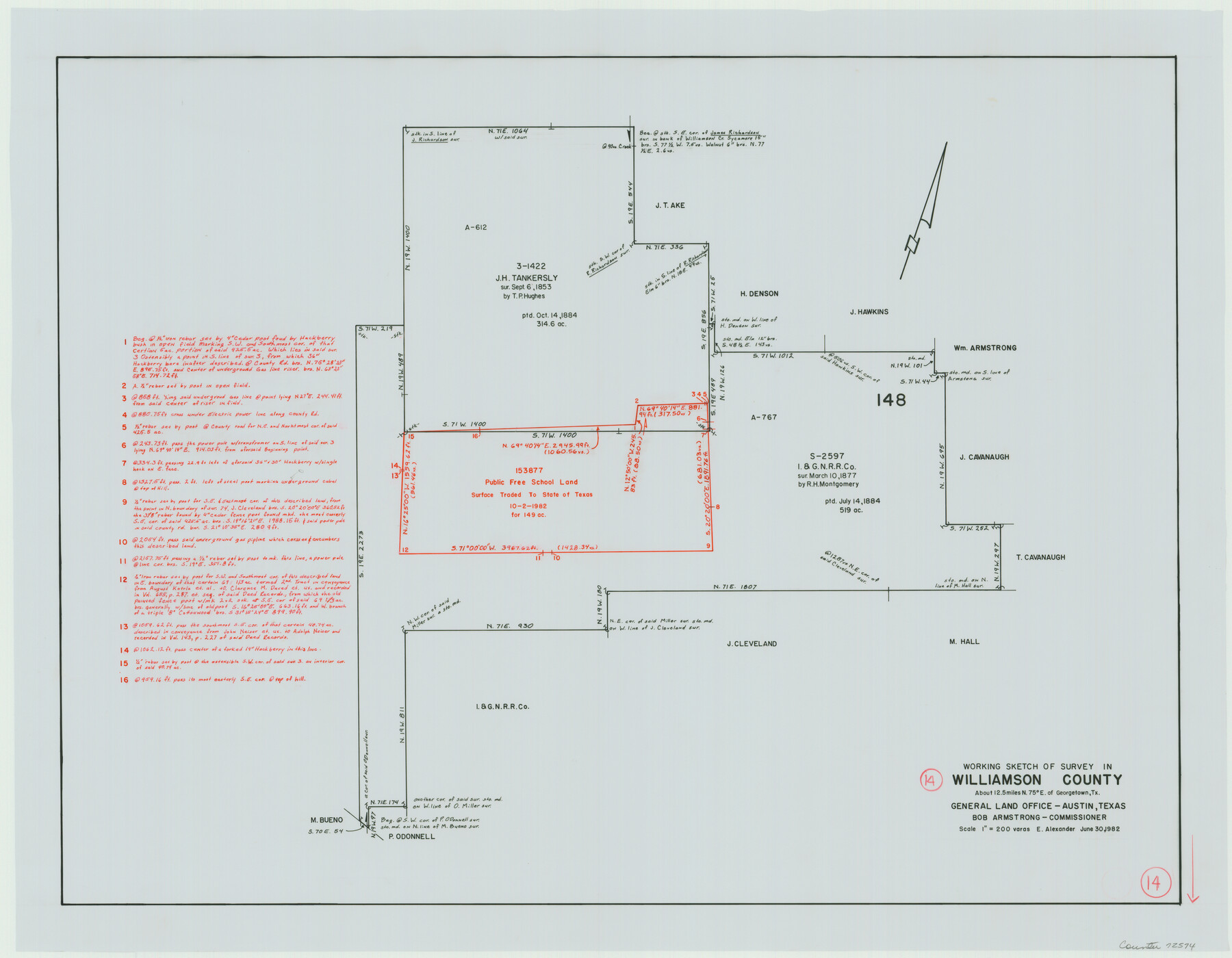
Williamson County Working Sketch 14
-
Map/Doc
72574
-
Collection
General Map Collection
-
Object Dates
6/30/1982 (Creation Date)
-
People and Organizations
Earl Alexander (Draftsman)
-
Counties
Williamson
-
Subjects
Surveying Working Sketch
-
Height x Width
22.0 x 28.3 inches
55.9 x 71.9 cm
-
Scale
1" = 200 varas
Part of: General Map Collection
Brazoria County NRC Article 33.136 Sketch 20

Print $36.00
- Digital $50.00
Brazoria County NRC Article 33.136 Sketch 20
2020
Map/Doc 96878
Deaf Smith County Sketch File 6

Print $12.00
- Digital $50.00
Deaf Smith County Sketch File 6
1912
Size 7.0 x 7.4 inches
Map/Doc 20658
Land Grant Map of Comal County

Print $20.00
- Digital $50.00
Land Grant Map of Comal County
2006
Size 33.3 x 41.0 inches
Map/Doc 83601
Limestone County Working Sketch 13

Print $20.00
- Digital $50.00
Limestone County Working Sketch 13
1922
Size 11.8 x 11.8 inches
Map/Doc 70563
Northwest Part Pecos County

Print $20.00
- Digital $50.00
Northwest Part Pecos County
1975
Size 42.4 x 43.1 inches
Map/Doc 73261
Hall County Sketch File B and B1

Print $14.00
- Digital $50.00
Hall County Sketch File B and B1
Size 9.2 x 8.5 inches
Map/Doc 24780
Aransas County Rolled Sketch 6

Print $20.00
- Digital $50.00
Aransas County Rolled Sketch 6
1953
Size 19.6 x 18.8 inches
Map/Doc 77190
Kinney County Working Sketch 33

Print $20.00
- Digital $50.00
Kinney County Working Sketch 33
1962
Size 39.0 x 44.2 inches
Map/Doc 70215
Bandera County Sketch File 26

Print $6.00
- Digital $50.00
Bandera County Sketch File 26
1879
Size 7.7 x 8.3 inches
Map/Doc 14016
Hartley County Sketch File 17

Print $4.00
- Digital $50.00
Hartley County Sketch File 17
1892
Size 11.2 x 8.9 inches
Map/Doc 26115
Map of the Reconnaissance in Texas by Lieuts Blake & Meade of the Corps of Topl. Engrs.

Print $20.00
- Digital $50.00
Map of the Reconnaissance in Texas by Lieuts Blake & Meade of the Corps of Topl. Engrs.
1845
Size 27.7 x 18.5 inches
Map/Doc 72892
Map of the Missouri Pacific Railway, St. Louis, Iron Mountain and Southern R'y

Print $20.00
- Digital $50.00
Map of the Missouri Pacific Railway, St. Louis, Iron Mountain and Southern R'y
1894
Size 11.4 x 17.5 inches
Map/Doc 93950
You may also like
Crockett County Working Sketch 13

Print $20.00
- Digital $50.00
Crockett County Working Sketch 13
1916
Size 16.6 x 18.5 inches
Map/Doc 68346
Flight Mission No. CUG-1P, Frame 47, Kleberg County

Print $20.00
- Digital $50.00
Flight Mission No. CUG-1P, Frame 47, Kleberg County
1956
Size 18.7 x 22.4 inches
Map/Doc 86125
Flight Mission No. DCL-7C, Frame 76, Kenedy County

Print $20.00
- Digital $50.00
Flight Mission No. DCL-7C, Frame 76, Kenedy County
1943
Size 15.4 x 15.1 inches
Map/Doc 86062
Wichita County Sketch File 15

Print $20.00
- Digital $50.00
Wichita County Sketch File 15
1886
Size 18.6 x 12.2 inches
Map/Doc 12679
Flight Mission No. DQN-2K, Frame 81, Calhoun County

Print $20.00
- Digital $50.00
Flight Mission No. DQN-2K, Frame 81, Calhoun County
1953
Size 18.7 x 22.3 inches
Map/Doc 84273
Dickens County Sketch File G

Print $8.00
- Digital $50.00
Dickens County Sketch File G
Size 12.0 x 8.7 inches
Map/Doc 20854
Rockwall County Sketch File 6

Print $4.00
- Digital $50.00
Rockwall County Sketch File 6
1862
Size 8.5 x 9.4 inches
Map/Doc 35425
Map of Calhoun County

Print $20.00
- Digital $50.00
Map of Calhoun County
1863
Size 23.0 x 19.5 inches
Map/Doc 887
Pecos County Working Sketch 110

Print $40.00
- Digital $50.00
Pecos County Working Sketch 110
1972
Size 32.3 x 50.6 inches
Map/Doc 71583
Map of Washington District

Print $20.00
- Digital $50.00
Map of Washington District
1847
Size 17.6 x 26.8 inches
Map/Doc 4125
English Field Notes of the Spanish Archives - Book J. Strode

English Field Notes of the Spanish Archives - Book J. Strode
1835
Map/Doc 96549
Nueces County Rolled Sketch 60

Print $40.00
- Digital $50.00
Nueces County Rolled Sketch 60
Size 95.5 x 32.3 inches
Map/Doc 9607