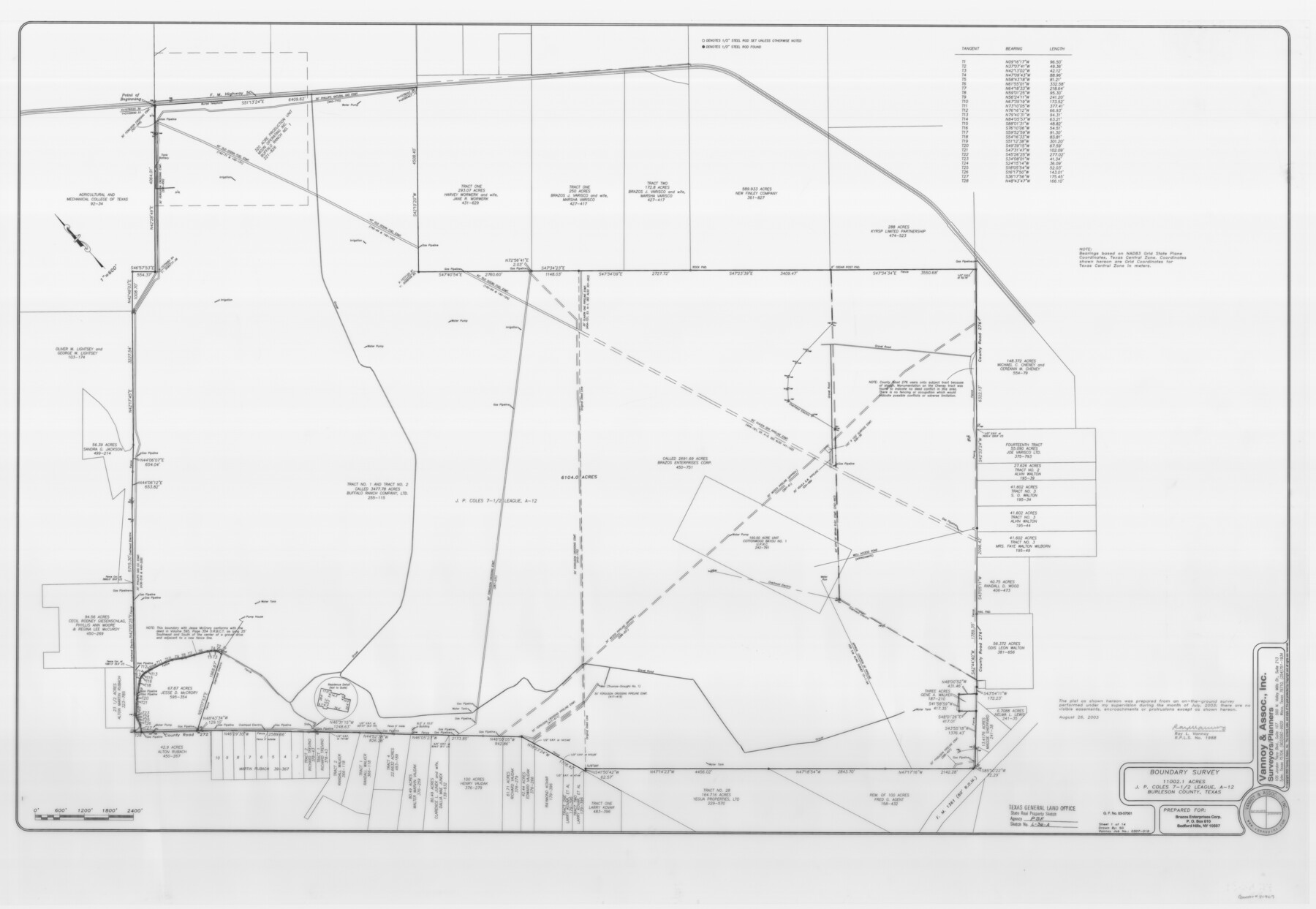
Burleson County State Real Property Sketch 1
A Boundary Survey of 11, 002.1 Acres Out of J. P. Coles 7 1/2 League, A - 12, "Buffalo Ranch"
State Real Property Sketch L - 36
-
Map/Doc
81907
-
Collection
General Map Collection
-
Object Dates
2003/8/26 (Creation Date)
2004/1/9 (File Date)
-
People and Organizations
Vannoy & Assoc., Inc. (Publisher)
Vannoy & Assoc., Inc. (Printer)
Ray L. Vannoy (Surveyor/Engineer)
S.G. (Draftsman)
-
Counties
Burleson
-
Subjects
State Real Property
-
Height x Width
37.0 x 53.6 inches
94.0 x 136.1 cm
-
Comments
Surveys located about 19 miles South 81 degrees East of Caldwell, Texas.
Part of: General Map Collection
La Salle County Rolled Sketch 4

Print $20.00
- Digital $50.00
La Salle County Rolled Sketch 4
1937
Size 20.9 x 27.5 inches
Map/Doc 6569
Flight Mission No. BRA-16M, Frame 83, Jefferson County

Print $20.00
- Digital $50.00
Flight Mission No. BRA-16M, Frame 83, Jefferson County
1953
Size 18.5 x 22.3 inches
Map/Doc 85695
Maverick County Working Sketch 18

Print $20.00
- Digital $50.00
Maverick County Working Sketch 18
1975
Size 44.4 x 35.3 inches
Map/Doc 70910
San Saba County Sketch File 14c

Print $40.00
- Digital $50.00
San Saba County Sketch File 14c
1894
Size 17.3 x 14.4 inches
Map/Doc 36452
Reeves County Rolled Sketch 22

Print $20.00
- Digital $50.00
Reeves County Rolled Sketch 22
1960
Size 40.8 x 20.9 inches
Map/Doc 7490
Flight Mission No. CRC-3R, Frame 20, Chambers County

Print $20.00
- Digital $50.00
Flight Mission No. CRC-3R, Frame 20, Chambers County
1956
Size 18.6 x 22.2 inches
Map/Doc 84794
Wilbarger Co.

Print $40.00
- Digital $50.00
Wilbarger Co.
1889
Size 48.8 x 38.4 inches
Map/Doc 63125
Crockett County Rolled Sketch 88J

Print $40.00
- Digital $50.00
Crockett County Rolled Sketch 88J
1973
Size 42.7 x 57.4 inches
Map/Doc 8734
Geological Map of Texas

Print $20.00
- Digital $50.00
Geological Map of Texas
1919
Size 34.9 x 36.8 inches
Map/Doc 94091
Jack County Sketch File 6

Print $8.00
- Digital $50.00
Jack County Sketch File 6
1856
Size 8.2 x 3.5 inches
Map/Doc 27513

McMullen County Rolled Sketch 18

Print $20.00
- Digital $50.00
McMullen County Rolled Sketch 18
Size 18.8 x 27.5 inches
Map/Doc 6734
You may also like
Map of the Fair Grounds Addition showing subdivisions of Out-lots 39, 49, 50 & 60, Division "O" in the City of Austin

Print $20.00
- Digital $50.00
Map of the Fair Grounds Addition showing subdivisions of Out-lots 39, 49, 50 & 60, Division "O" in the City of Austin
1909
Size 21.4 x 13.3 inches
Map/Doc 2022
Harris County Sketch File 1

Print $20.00
- Digital $50.00
Harris County Sketch File 1
Size 14.8 x 12.6 inches
Map/Doc 25332
McMullen County Sketch File 9

Print $4.00
- Digital $50.00
McMullen County Sketch File 9
1876
Size 14.4 x 8.4 inches
Map/Doc 31351
Railroad and County Map of Texas

Print $20.00
Railroad and County Map of Texas
1901
Size 33.1 x 37.1 inches
Map/Doc 76213
[Warren Additions 3 and 4 and vicinity]
![92464, [Warren Additions 3 and 4 and vicinity], Twichell Survey Records](https://historictexasmaps.com/wmedia_w700/maps/92464-1.tif.jpg)
Print $20.00
- Digital $50.00
[Warren Additions 3 and 4 and vicinity]
Size 23.9 x 19.5 inches
Map/Doc 92464
Lynn County Sketch File 14

Print $12.00
- Digital $50.00
Lynn County Sketch File 14
1916
Size 14.1 x 8.7 inches
Map/Doc 30491
Map of Portion of Laguna Madre in Nueces & Kleberg Counties showing subdivision thereof for mineral development

Print $20.00
- Digital $50.00
Map of Portion of Laguna Madre in Nueces & Kleberg Counties showing subdivision thereof for mineral development
1937
Size 38.6 x 30.8 inches
Map/Doc 2918
Lynn County Sketch File A1

Print $12.00
- Digital $50.00
Lynn County Sketch File A1
1903
Size 12.7 x 8.2 inches
Map/Doc 30464
Map of Comal County

Print $20.00
- Digital $50.00
Map of Comal County
1871
Size 16.0 x 19.7 inches
Map/Doc 3430

Grayson County Sketch File 13

Print $40.00
- Digital $50.00
Grayson County Sketch File 13
1853
Size 16.2 x 14.4 inches
Map/Doc 24480
Pecos County Rolled Sketch 27

Print $20.00
- Digital $50.00
Pecos County Rolled Sketch 27
1890
Size 32.3 x 28.3 inches
Map/Doc 7212