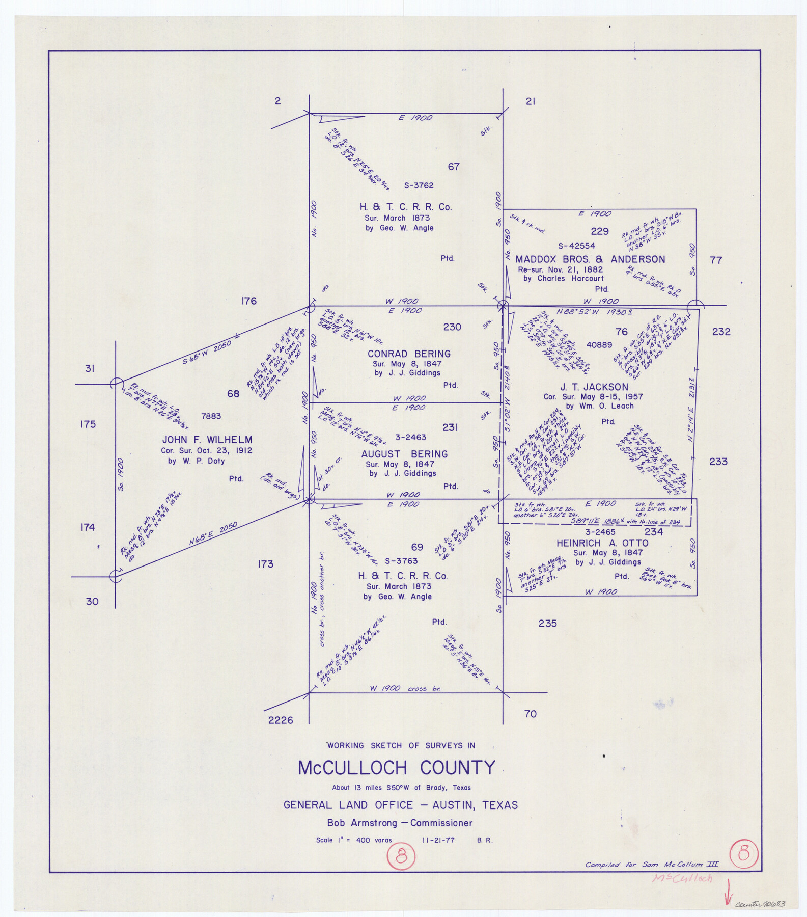
McCulloch County Working Sketch 8
-
Map/Doc
70683
-
Collection
General Map Collection
-
Object Dates
11/21/1977 (Creation Date)
-
People and Organizations
Beverly Robison (Draftsman)
-
Counties
McCulloch
-
Subjects
Surveying Working Sketch
-
Height x Width
22.5 x 19.8 inches
57.2 x 50.3 cm
-
Scale
1" = 400 varas
Part of: General Map Collection

Flight Mission No. CRC-4R, Frame 63, Chambers County

Print $20.00
- Digital $50.00
Flight Mission No. CRC-4R, Frame 63, Chambers County
1956
Size 18.7 x 22.4 inches
Map/Doc 84867
Hartley County

Print $40.00
- Digital $50.00
Hartley County
1925
Size 41.1 x 48.5 inches
Map/Doc 73174
Sutton County Working Sketch 49

Print $20.00
- Digital $50.00
Sutton County Working Sketch 49
1955
Size 43.3 x 19.5 inches
Map/Doc 62392
Kerr County Working Sketch 3

Print $20.00
- Digital $50.00
Kerr County Working Sketch 3
1944
Size 15.7 x 21.0 inches
Map/Doc 70034
Edwards County Sketch File 54

Print $20.00
- Digital $50.00
Edwards County Sketch File 54
Size 17.9 x 18.4 inches
Map/Doc 11447
Hays County Working Sketch 23

Print $20.00
- Digital $50.00
Hays County Working Sketch 23
2011
Size 30.5 x 29.2 inches
Map/Doc 90090
La Salle County Working Sketch 49

Print $20.00
- Digital $50.00
La Salle County Working Sketch 49
1984
Size 31.7 x 29.0 inches
Map/Doc 70350
Flight Mission No. DAG-24K, Frame 126, Matagorda County

Print $20.00
- Digital $50.00
Flight Mission No. DAG-24K, Frame 126, Matagorda County
1953
Size 17.0 x 19.1 inches
Map/Doc 86544
Routes to HemisFair '68 : World's Fair, San Antonio, Texas, April 6 through Oct. 6, 1968 [Verso]
![94169, Hemisfair Gulf Tourgide Map [Verso], General Map Collection](https://historictexasmaps.com/wmedia_w700/maps/94169.tif.jpg)
Routes to HemisFair '68 : World's Fair, San Antonio, Texas, April 6 through Oct. 6, 1968 [Verso]
Size 18.3 x 24.3 inches
Map/Doc 94169
Baylor County Sketch File 26

Print $22.00
- Digital $50.00
Baylor County Sketch File 26
Size 14.6 x 9.0 inches
Map/Doc 14215
Denton County Rolled Sketch 3

Print $20.00
- Digital $50.00
Denton County Rolled Sketch 3
1959
Size 39.1 x 23.9 inches
Map/Doc 5700
You may also like
Tom Green County Sketch File 63A

Print $20.00
- Digital $50.00
Tom Green County Sketch File 63A
1891
Size 24.9 x 34.5 inches
Map/Doc 12446
Goliad County Working Sketch 22

Print $20.00
- Digital $50.00
Goliad County Working Sketch 22
1971
Size 33.1 x 36.8 inches
Map/Doc 63212
Cooke County Working Sketch 38

Print $40.00
- Digital $50.00
Cooke County Working Sketch 38
1997
Size 48.2 x 36.6 inches
Map/Doc 68275
Angelina County Boundary File 2

Print $20.00
- Digital $50.00
Angelina County Boundary File 2
Size 10.2 x 28.2 inches
Map/Doc 49773
Pecos County Rolled Sketch ANL

Print $20.00
- Digital $50.00
Pecos County Rolled Sketch ANL
Size 31.5 x 38.4 inches
Map/Doc 7308
Nueces County Rolled Sketch 27B

Print $108.00
- Digital $50.00
Nueces County Rolled Sketch 27B
1948
Size 9.8 x 15.1 inches
Map/Doc 47604
Matagorda County Rolled Sketch PHL1

Print $20.00
- Digital $50.00
Matagorda County Rolled Sketch PHL1
Size 36.5 x 39.1 inches
Map/Doc 9477
[State Capitol Leagues and County School Leagues]
![92475, [State Capitol Leagues and County School Leagues], Twichell Survey Records](https://historictexasmaps.com/wmedia_w700/maps/92475-1.tif.jpg)
Print $20.00
- Digital $50.00
[State Capitol Leagues and County School Leagues]
Size 19.4 x 11.8 inches
Map/Doc 92475
Kendall County Sketch File 1

Print $4.00
- Digital $50.00
Kendall County Sketch File 1
Size 9.6 x 8.3 inches
Map/Doc 28671
Jackson County Working Sketch 14

Print $20.00
- Digital $50.00
Jackson County Working Sketch 14
1990
Size 31.7 x 32.2 inches
Map/Doc 66462
Pecos County Working Sketch 86

Print $20.00
- Digital $50.00
Pecos County Working Sketch 86
1962
Size 39.0 x 32.7 inches
Map/Doc 71558
Duval County Boundary File 3b

Print $4.00
- Digital $50.00
Duval County Boundary File 3b
Size 12.9 x 8.2 inches
Map/Doc 52730