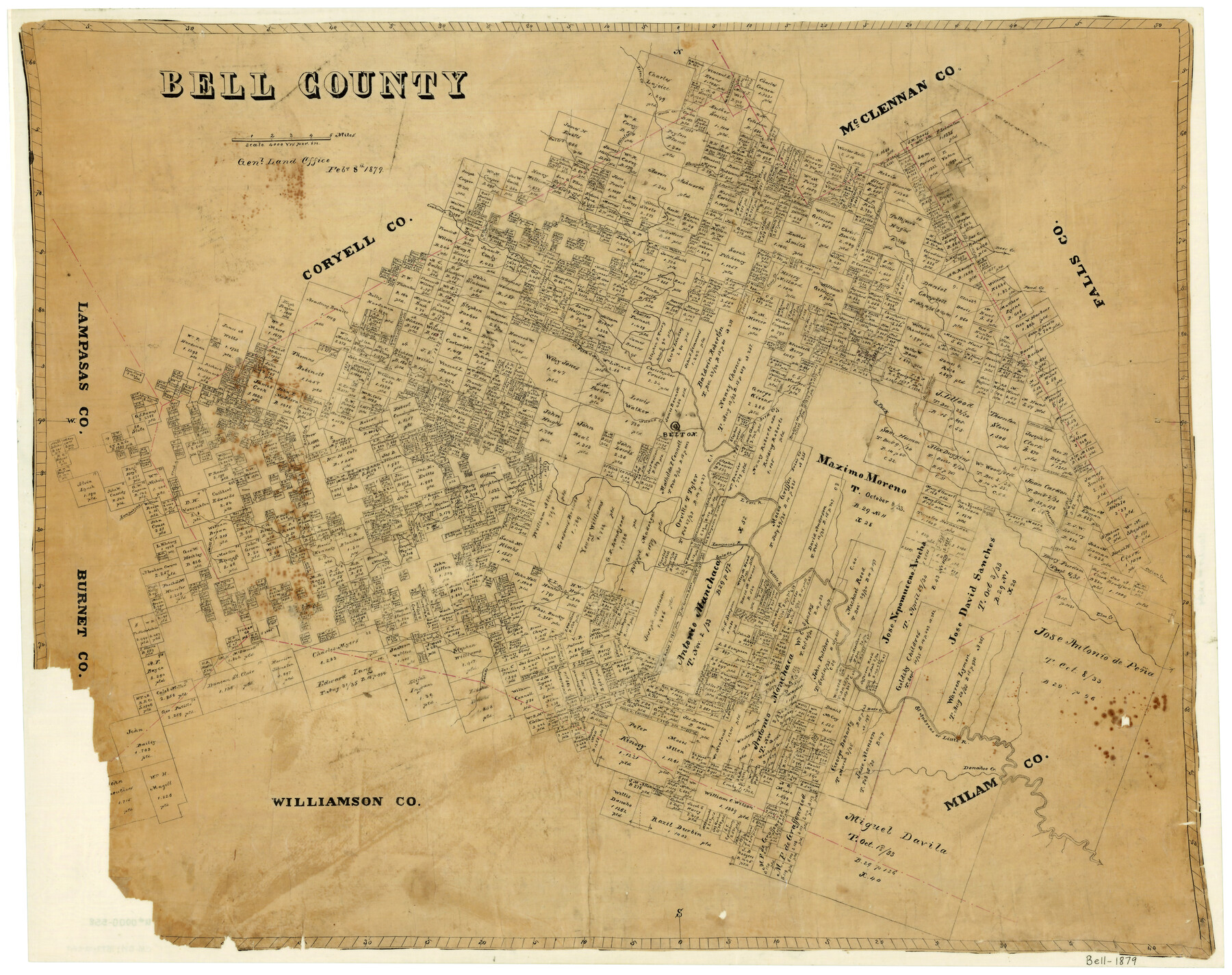
Bell County
-
Map/Doc
3294
-
Collection
General Map Collection
-
Object Dates
2/8/1879 (Creation Date)
-
People and Organizations
Texas General Land Office (Publisher)
-
Counties
Bell
-
Subjects
County
-
Height x Width
23.6 x 29.7 inches
59.9 x 75.4 cm
-
Features
Lampassas [sic] River
Elm Springs Creek
Indian Creek
Clear Creek
Trimmier Creek
Freeman Creek
Mitchell Creek
South Fork of Elm Creek
Donahoe Creek
St. Andreas River
Darr Creek
Bear Creek
Reynold's Creek
Little River
Salade [sic] River
Mill Creek
Leon Creek
Friar Creek
Leon River
Belton
Noland Creek
Reese Creek
North Fork of Noland Creek
Pond Creek
Deer Creek
Elm Creek
Ceder [sic] Creek
Cowhouse Creek
Stampede Creek
Owl Creek
Flint Creek
Horse Creek
Part of: General Map Collection
Fort Bend County Sketch File 1

Print $6.00
- Digital $50.00
Fort Bend County Sketch File 1
Size 14.7 x 9.5 inches
Map/Doc 22876
Flight Mission No. BRA-16M, Frame 77, Jefferson County

Print $20.00
- Digital $50.00
Flight Mission No. BRA-16M, Frame 77, Jefferson County
1953
Size 18.6 x 22.3 inches
Map/Doc 85694
Fort Bend County State Real Property Sketch 1

Print $40.00
- Digital $50.00
Fort Bend County State Real Property Sketch 1
1986
Size 34.7 x 43.2 inches
Map/Doc 61675
Tarrant County Working Sketch 2

Print $20.00
- Digital $50.00
Tarrant County Working Sketch 2
1940
Size 21.3 x 19.5 inches
Map/Doc 62419
San Patricio County Rolled Sketch 29B

Print $20.00
- Digital $50.00
San Patricio County Rolled Sketch 29B
1936
Size 25.8 x 31.0 inches
Map/Doc 7582
Aransas County Sketch File 37

Print $139.00
- Digital $50.00
Aransas County Sketch File 37
1995
Size 11.1 x 9.1 inches
Map/Doc 13413
Reeves County Rolled Sketch 38

Print $20.00
- Digital $50.00
Reeves County Rolled Sketch 38
2018
Size 24.4 x 38.6 inches
Map/Doc 95385
Jack County Sketch File 14 1/2

Print $4.00
- Digital $50.00
Jack County Sketch File 14 1/2
1876
Size 8.5 x 12.7 inches
Map/Doc 27543
Cochran County Sketch File 7

Print $10.00
- Digital $50.00
Cochran County Sketch File 7
1940
Size 11.2 x 8.6 inches
Map/Doc 18550
Polk County Working Sketch 41

Print $20.00
- Digital $50.00
Polk County Working Sketch 41
1985
Size 26.3 x 27.8 inches
Map/Doc 71658
Terrell County Rolled Sketch 36

Print $20.00
- Digital $50.00
Terrell County Rolled Sketch 36
1940
Size 17.4 x 33.8 inches
Map/Doc 9989
Orange County Working Sketch 46

Print $3.00
- Digital $50.00
Orange County Working Sketch 46
1982
Size 10.8 x 9.9 inches
Map/Doc 71378
You may also like
Presidio County Rolled Sketch 80A

Print $20.00
- Digital $50.00
Presidio County Rolled Sketch 80A
Size 26.9 x 28.9 inches
Map/Doc 7367
Nueces County Rolled Sketch 108

Print $62.00
Nueces County Rolled Sketch 108
1987
Size 18.6 x 23.5 inches
Map/Doc 7112
Disputed Territory Between Mexico and the United States

Disputed Territory Between Mexico and the United States
2024
Size 10.7 x 7.9 inches
Map/Doc 97251
Mason County Boundary File 63

Print $10.00
- Digital $50.00
Mason County Boundary File 63
Size 9.4 x 5.9 inches
Map/Doc 56879
Flight Mission No. DQN-1K, Frame 125, Calhoun County

Print $20.00
- Digital $50.00
Flight Mission No. DQN-1K, Frame 125, Calhoun County
1953
Size 18.4 x 22.1 inches
Map/Doc 84191
Zapata County

Print $40.00
- Digital $50.00
Zapata County
1901
Size 53.1 x 38.0 inches
Map/Doc 63143
Panola County

Print $20.00
- Digital $50.00
Panola County
1947
Size 40.8 x 40.3 inches
Map/Doc 66969
La Florida / Peruviae Avriferæ Regionis Typus / Guastecan

Print $20.00
- Digital $50.00
La Florida / Peruviae Avriferæ Regionis Typus / Guastecan
1584
Size 16.8 x 20.9 inches
Map/Doc 94100
Duval County Rolled Sketch 48

Print $20.00
- Digital $50.00
Duval County Rolled Sketch 48
Size 21.8 x 18.5 inches
Map/Doc 5762
Smith County Rolled Sketch 3

Print $40.00
- Digital $50.00
Smith County Rolled Sketch 3
Size 55.2 x 42.8 inches
Map/Doc 9934
General Highway Map. Detail of Cities and Towns in Lubbock County, Texas [Lubbock and vicinity]
![79181, General Highway Map. Detail of Cities and Towns in Lubbock County, Texas [Lubbock and vicinity], Texas State Library and Archives](https://historictexasmaps.com/wmedia_w700/maps/79181.tif.jpg)
Print $20.00
General Highway Map. Detail of Cities and Towns in Lubbock County, Texas [Lubbock and vicinity]
1940
Size 18.3 x 24.8 inches
Map/Doc 79181
Gaines County Rolled Sketch 15B

Print $40.00
- Digital $50.00
Gaines County Rolled Sketch 15B
Size 207.7 x 26.0 inches
Map/Doc 9037