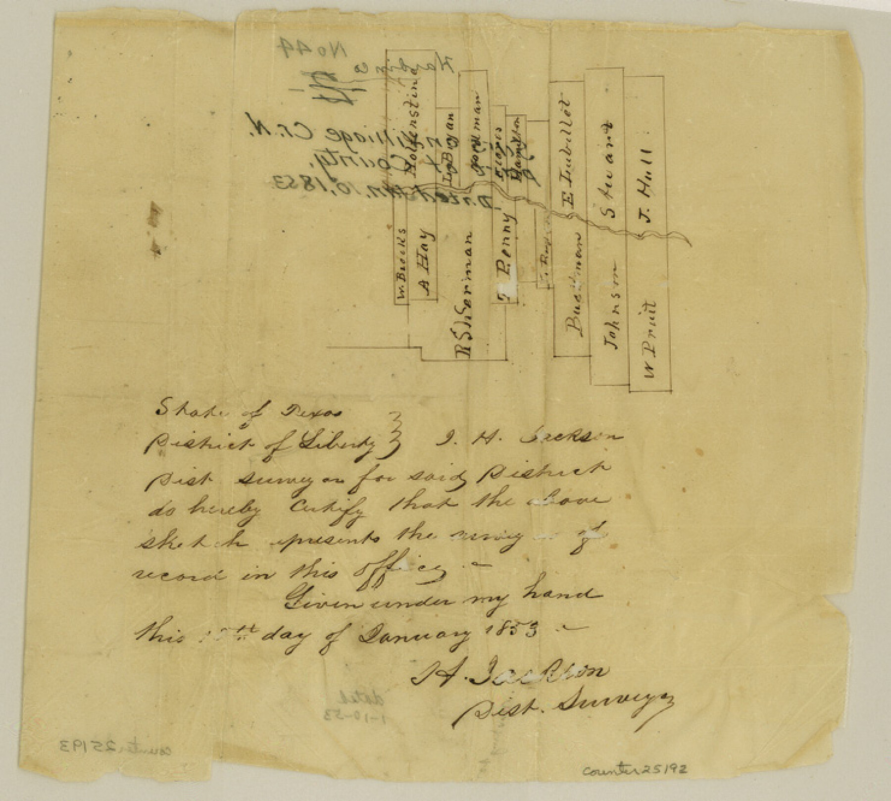
Hardin County Sketch File 44
[Sketch of surveys on Villiage Creek in north part of county]
-
Map/Doc
25192
-
Collection
General Map Collection
-
Object Dates
1853/1/10 (Survey Date)
-
People and Organizations
H. Jackson (Surveyor/Engineer)
-
Counties
Hardin Tyler
-
Subjects
Surveying Sketch File
-
Height x Width
6.7 x 7.4 inches
17.0 x 18.8 cm
-
Medium
paper, manuscript
-
Features
Village Creek
Part of: General Map Collection
Montgomery County Sketch File 27

Print $20.00
- Digital $50.00
Montgomery County Sketch File 27
1932
Size 37.3 x 41.9 inches
Map/Doc 10548
Harrison County Sketch File 6

Print $4.00
- Digital $50.00
Harrison County Sketch File 6
Size 12.9 x 8.1 inches
Map/Doc 26044
Live Oak County Working Sketch 30

Print $20.00
- Digital $50.00
Live Oak County Working Sketch 30
1988
Size 19.0 x 25.9 inches
Map/Doc 70615
Freestone County Rolled Sketch 2

Print $20.00
- Digital $50.00
Freestone County Rolled Sketch 2
1952
Size 27.1 x 30.2 inches
Map/Doc 5910
Webb County Working Sketch 98

Print $40.00
- Digital $50.00
Webb County Working Sketch 98
2012
Size 36.9 x 72.0 inches
Map/Doc 93276
Flight Mission No. DQN-1K, Frame 82, Calhoun County

Print $20.00
- Digital $50.00
Flight Mission No. DQN-1K, Frame 82, Calhoun County
1953
Size 18.5 x 22.2 inches
Map/Doc 84167
Erath County Working Sketch 25

Print $20.00
- Digital $50.00
Erath County Working Sketch 25
1968
Size 26.8 x 20.3 inches
Map/Doc 69106
Angelina County Working Sketch 32b

Print $20.00
- Digital $50.00
Angelina County Working Sketch 32b
1955
Size 23.0 x 28.6 inches
Map/Doc 67115
Brazoria County State Real Property Sketch 1

Print $20.00
- Digital $50.00
Brazoria County State Real Property Sketch 1
1997
Size 24.4 x 34.8 inches
Map/Doc 80127
Dimmit County Boundary File 8

Print $48.00
- Digital $50.00
Dimmit County Boundary File 8
Size 7.2 x 37.2 inches
Map/Doc 52597
Brooks County Working Sketch 9

Print $20.00
- Digital $50.00
Brooks County Working Sketch 9
1931
Size 25.7 x 38.7 inches
Map/Doc 67793
Nueces County Rolled Sketch 67

Print $20.00
- Digital $50.00
Nueces County Rolled Sketch 67
1979
Size 25.4 x 36.9 inches
Map/Doc 6918
You may also like
Rusk County Working Sketch 22

Print $20.00
- Digital $50.00
Rusk County Working Sketch 22
1950
Size 22.5 x 12.8 inches
Map/Doc 63658
Flight Mission No. BRE-1P, Frame 145, Nueces County

Print $20.00
- Digital $50.00
Flight Mission No. BRE-1P, Frame 145, Nueces County
1956
Size 18.4 x 22.1 inches
Map/Doc 86705

Calhoun County

Print $20.00
- Digital $50.00
Calhoun County
1871
Size 22.4 x 18.3 inches
Map/Doc 888
Baffin and Alazan Bays, Cayo Infiernillo in Kenedy and Kleberg Counties, showing Subdivision for Mineral Development

Print $40.00
- Digital $50.00
Baffin and Alazan Bays, Cayo Infiernillo in Kenedy and Kleberg Counties, showing Subdivision for Mineral Development
1949
Size 33.0 x 52.4 inches
Map/Doc 1923
Flight Mission No. DQN-1K, Frame 141, Calhoun County

Print $20.00
- Digital $50.00
Flight Mission No. DQN-1K, Frame 141, Calhoun County
1953
Size 18.5 x 22.1 inches
Map/Doc 84204
Hutchinson County Rolled Sketch 21

Print $20.00
- Digital $50.00
Hutchinson County Rolled Sketch 21
Size 28.4 x 36.1 inches
Map/Doc 6286
Cass County Working Sketch 52

Print $20.00
- Digital $50.00
Cass County Working Sketch 52
2001
Size 32.9 x 23.9 inches
Map/Doc 67955
Cherokee County Sketch File 8

Print $4.00
- Digital $50.00
Cherokee County Sketch File 8
1854
Size 10.3 x 8.1 inches
Map/Doc 18130
Henderson County Rolled Sketch 11

Print $20.00
- Digital $50.00
Henderson County Rolled Sketch 11
1915
Size 29.5 x 42.5 inches
Map/Doc 75960
Crockett County Sketch File 25

Print $26.00
- Digital $50.00
Crockett County Sketch File 25
1881
Size 12.9 x 8.3 inches
Map/Doc 19703
Under Sapphire Skies San Antonio

Under Sapphire Skies San Antonio
1928
Size 9.4 x 6.4 inches
Map/Doc 97043