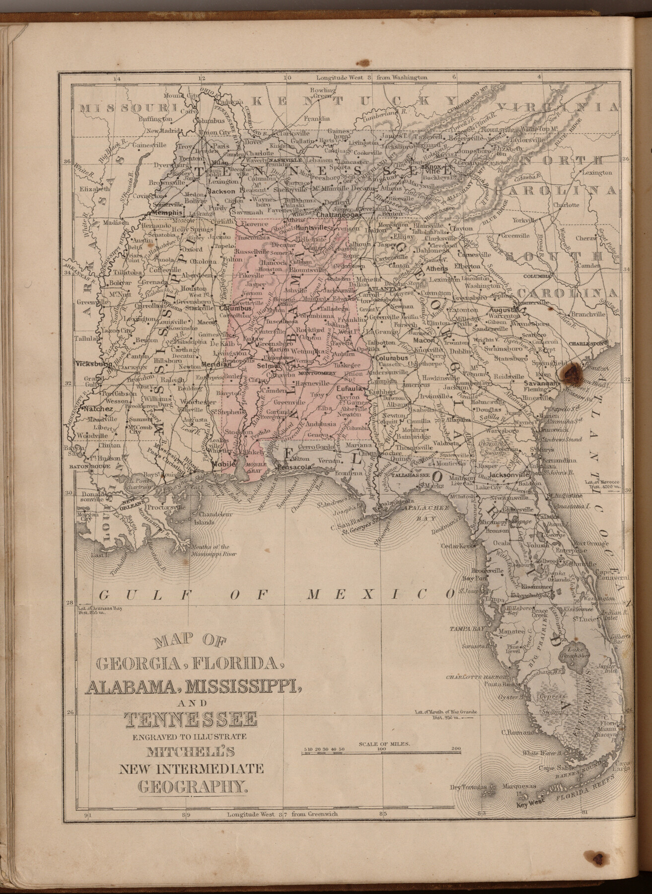
Map of Georgia, Florida, Alabama, Mississippi and Tennessee engraved to illustrate Mitchell's new intermediate geography
-
Map/Doc
93518
-
Collection
General Map Collection
-
Object Dates
1885 (Creation Date)
2013/7/12 (File Date)
-
People and Organizations
E. H. Butler and Co. (Publisher)
Galen Greaser (Donor)
S. Augustus Mitchell (Author)
-
Subjects
Atlas
-
Height x Width
12.2 x 9.0 inches
31.0 x 22.9 cm
-
Comments
Donated by Galen Greaser in 2009. Map is part of volume: "Mitchell's New Intermediate Geography (Louisiana Edition)". See 93509 for complete atlas.
Related maps
Mitchell's New Intermediate Geography (Louisiana Edition)

Print $819.00
- Digital $50.00
Mitchell's New Intermediate Geography (Louisiana Edition)
1885
Size 12.5 x 10.0 inches
Map/Doc 93509
Part of: General Map Collection
Pecos County Working Sketch 91b

Print $40.00
- Digital $50.00
Pecos County Working Sketch 91b
1965
Size 78.9 x 32.7 inches
Map/Doc 71564
Flight Mission No. DAG-24K, Frame 43, Matagorda County

Print $20.00
- Digital $50.00
Flight Mission No. DAG-24K, Frame 43, Matagorda County
1953
Size 16.1 x 15.8 inches
Map/Doc 86530
Map of Haskell County

Print $20.00
- Digital $50.00
Map of Haskell County
1899
Size 40.1 x 35.3 inches
Map/Doc 16847
Coke County Rolled Sketch 22

Print $20.00
- Digital $50.00
Coke County Rolled Sketch 22
1957
Size 18.2 x 22.6 inches
Map/Doc 5523
Goliad County Sketch File 21

Print $10.00
- Digital $50.00
Goliad County Sketch File 21
1855
Size 12.0 x 7.9 inches
Map/Doc 24284
Caldwell County Sketch File 2

Print $40.00
- Digital $50.00
Caldwell County Sketch File 2
1877
Size 12.9 x 20.0 inches
Map/Doc 11030
Hudspeth County Rolled Sketch 26

Print $20.00
- Digital $50.00
Hudspeth County Rolled Sketch 26
1909
Size 19.3 x 18.0 inches
Map/Doc 6247
Wichita County Sketch File 14

Print $20.00
- Digital $50.00
Wichita County Sketch File 14
1885
Size 17.7 x 17.0 inches
Map/Doc 12678
Tarrant County Sketch File 32

Print $16.00
- Digital $50.00
Tarrant County Sketch File 32
1946
Size 11.3 x 8.8 inches
Map/Doc 37751
North America

Print $20.00
- Digital $50.00
North America
1843
Size 16.7 x 13.7 inches
Map/Doc 95366
Foard County Sketch File 35

Print $20.00
- Digital $50.00
Foard County Sketch File 35
Size 26.4 x 25.7 inches
Map/Doc 11496
Map of parts of Texas, Mexico and New Mexico

Print $4.00
- Digital $50.00
Map of parts of Texas, Mexico and New Mexico
1877
Size 18.1 x 21.8 inches
Map/Doc 65403
You may also like
Map of Glasscock County

Print $20.00
- Digital $50.00
Map of Glasscock County
Size 18.9 x 23.1 inches
Map/Doc 90710
Marion County Sketch File 17

Print $20.00
- Digital $50.00
Marion County Sketch File 17
Size 32.7 x 19.0 inches
Map/Doc 12026
San Patricio County Rolled Sketch 46E

Print $20.00
- Digital $50.00
San Patricio County Rolled Sketch 46E
1983
Size 17.4 x 46.3 inches
Map/Doc 8376
Nueces County NRC Article 33.136 Location Key Sheet

Print $20.00
- Digital $50.00
Nueces County NRC Article 33.136 Location Key Sheet
1975
Size 27.0 x 23.0 inches
Map/Doc 88586
Cottle County Working Sketch 14B

Print $20.00
- Digital $50.00
Cottle County Working Sketch 14B
1963
Size 35.2 x 41.6 inches
Map/Doc 61795
Newton County Working Sketch 42

Print $20.00
- Digital $50.00
Newton County Working Sketch 42
1981
Size 26.4 x 22.5 inches
Map/Doc 71288
Upton County Rolled Sketch 33

Print $20.00
- Digital $50.00
Upton County Rolled Sketch 33
1951
Size 39.2 x 33.0 inches
Map/Doc 8076
Flight Mission No. CUG-1P, Frame 80, Kleberg County

Print $20.00
- Digital $50.00
Flight Mission No. CUG-1P, Frame 80, Kleberg County
1956
Size 18.8 x 22.4 inches
Map/Doc 86145
Aransas County NRC Article 33.136 Sketch 11

Print $54.00
- Digital $50.00
Aransas County NRC Article 33.136 Sketch 11
2012
Size 36.0 x 48.0 inches
Map/Doc 94502
Hardeman County Working Sketch 12

Print $40.00
- Digital $50.00
Hardeman County Working Sketch 12
1963
Size 31.2 x 54.3 inches
Map/Doc 63393

Flight Mission No. CGI-3N, Frame 132, Cameron County

Print $20.00
- Digital $50.00
Flight Mission No. CGI-3N, Frame 132, Cameron County
1954
Size 18.4 x 22.2 inches
Map/Doc 84605