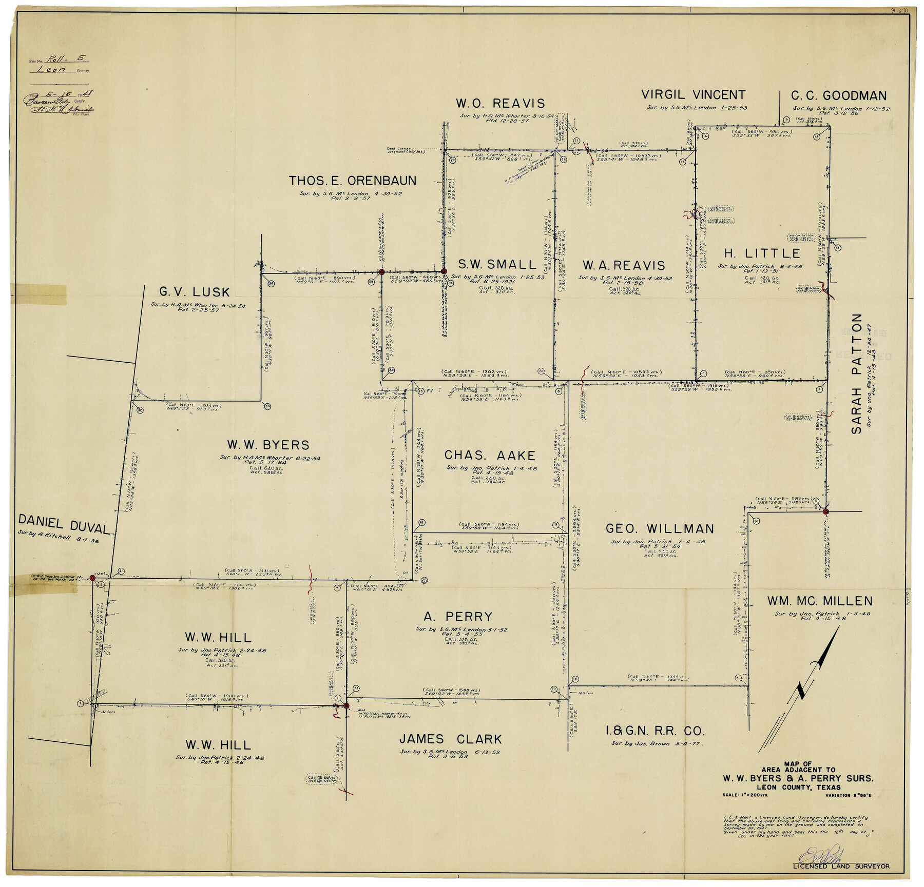
Leon County Rolled Sketch 5
Map of area adjacent to W.W. Byers & A. Perry surs., Leon County, Texas
-
Map/Doc
9427
-
Collection
General Map Collection
-
Object Dates
12/10/1947 (Creation Date)
5/15/1948 (File Date)
9/20/1947 (Survey Date)
-
People and Organizations
E.S. Rest (Surveyor/Engineer)
-
Counties
Leon
-
Subjects
Surveying Rolled Sketch
-
Height x Width
33.7 x 34.8 inches
85.6 x 88.4 cm
-
Medium
blueprint/diazo
-
Scale
1" = 200 varas
Part of: General Map Collection
Harris County Sketch File 74

Print $22.00
- Digital $50.00
Harris County Sketch File 74
1944
Size 17.1 x 12.2 inches
Map/Doc 25543
Atascosa County Rolled Sketch 22

Print $40.00
- Digital $50.00
Atascosa County Rolled Sketch 22
1917
Size 25.9 x 57.4 inches
Map/Doc 8920
Terrell County Working Sketch 54

Print $20.00
- Digital $50.00
Terrell County Working Sketch 54
1959
Size 25.2 x 42.9 inches
Map/Doc 62147
Atascosa County Rolled Sketch 5A

Print $20.00
- Digital $50.00
Atascosa County Rolled Sketch 5A
1910
Size 20.8 x 14.4 inches
Map/Doc 5089
Houston & Great Northern RR through Smith & other counties

Print $66.00
- Digital $50.00
Houston & Great Northern RR through Smith & other counties
1872
Size 14.2 x 8.4 inches
Map/Doc 64339
Pecos County Working Sketch 5

Print $20.00
- Digital $50.00
Pecos County Working Sketch 5
1886
Size 22.8 x 19.2 inches
Map/Doc 71475

Duval County Sketch File 27

Print $6.00
- Digital $50.00
Duval County Sketch File 27
1919
Size 11.0 x 11.8 inches
Map/Doc 21334
University Land in Cooke County

Print $20.00
- Digital $50.00
University Land in Cooke County
1906
Size 23.6 x 30.0 inches
Map/Doc 2425
Eastland County Working Sketch 65

Print $20.00
- Digital $50.00
Eastland County Working Sketch 65
1986
Size 37.4 x 16.5 inches
Map/Doc 88892
Brazoria County Sketch File 31

Print $40.00
- Digital $50.00
Brazoria County Sketch File 31
1894
Size 17.4 x 14.4 inches
Map/Doc 15039
Flight Mission No. BRA-9M, Frame 71, Jefferson County

Print $20.00
- Digital $50.00
Flight Mission No. BRA-9M, Frame 71, Jefferson County
1953
Size 18.5 x 22.4 inches
Map/Doc 85654
You may also like
Flight Mission No. DQN-6K, Frame 4, Calhoun County

Print $20.00
- Digital $50.00
Flight Mission No. DQN-6K, Frame 4, Calhoun County
1953
Size 18.4 x 22.1 inches
Map/Doc 84426
Mitchell County, Texas

Print $20.00
- Digital $50.00
Mitchell County, Texas
1870
Size 22.7 x 18.0 inches
Map/Doc 741
Coryell County Working Sketch 22

Print $20.00
- Digital $50.00
Coryell County Working Sketch 22
1976
Size 24.9 x 35.3 inches
Map/Doc 68229
Bee County Working Sketch 15

Print $20.00
- Digital $50.00
Bee County Working Sketch 15
1974
Size 20.4 x 27.9 inches
Map/Doc 67265
Clay County Sketch File 18

Print $4.00
- Digital $50.00
Clay County Sketch File 18
1875
Size 12.6 x 8.4 inches
Map/Doc 18427
Crockett County Rolled Sketch 90

Print $20.00
- Digital $50.00
Crockett County Rolled Sketch 90
1975
Size 25.4 x 37.3 inches
Map/Doc 5631
Maps of Gulf Intracoastal Waterway, Texas - Sabine River to the Rio Grande and connecting waterways including ship channels

Print $20.00
- Digital $50.00
Maps of Gulf Intracoastal Waterway, Texas - Sabine River to the Rio Grande and connecting waterways including ship channels
1966
Size 14.6 x 22.2 inches
Map/Doc 61939
Refugio County Sketch File 14

Print $2.00
- Digital $50.00
Refugio County Sketch File 14
Size 12.8 x 8.1 inches
Map/Doc 35267
Hockley County Sketch File 1

Print $20.00
- Digital $50.00
Hockley County Sketch File 1
Size 20.3 x 18.9 inches
Map/Doc 11767
Roberts County Boundary File 1

Print $40.00
- Digital $50.00
Roberts County Boundary File 1
Size 14.4 x 8.9 inches
Map/Doc 58313
Flight Mission No. BRE-2P, Frame 125, Nueces County

Print $20.00
- Digital $50.00
Flight Mission No. BRE-2P, Frame 125, Nueces County
1956
Size 18.5 x 22.6 inches
Map/Doc 86801
Amistad International Reservoir on Rio Grande 81

Print $20.00
- Digital $50.00
Amistad International Reservoir on Rio Grande 81
1949
Size 28.6 x 40.2 inches
Map/Doc 75510