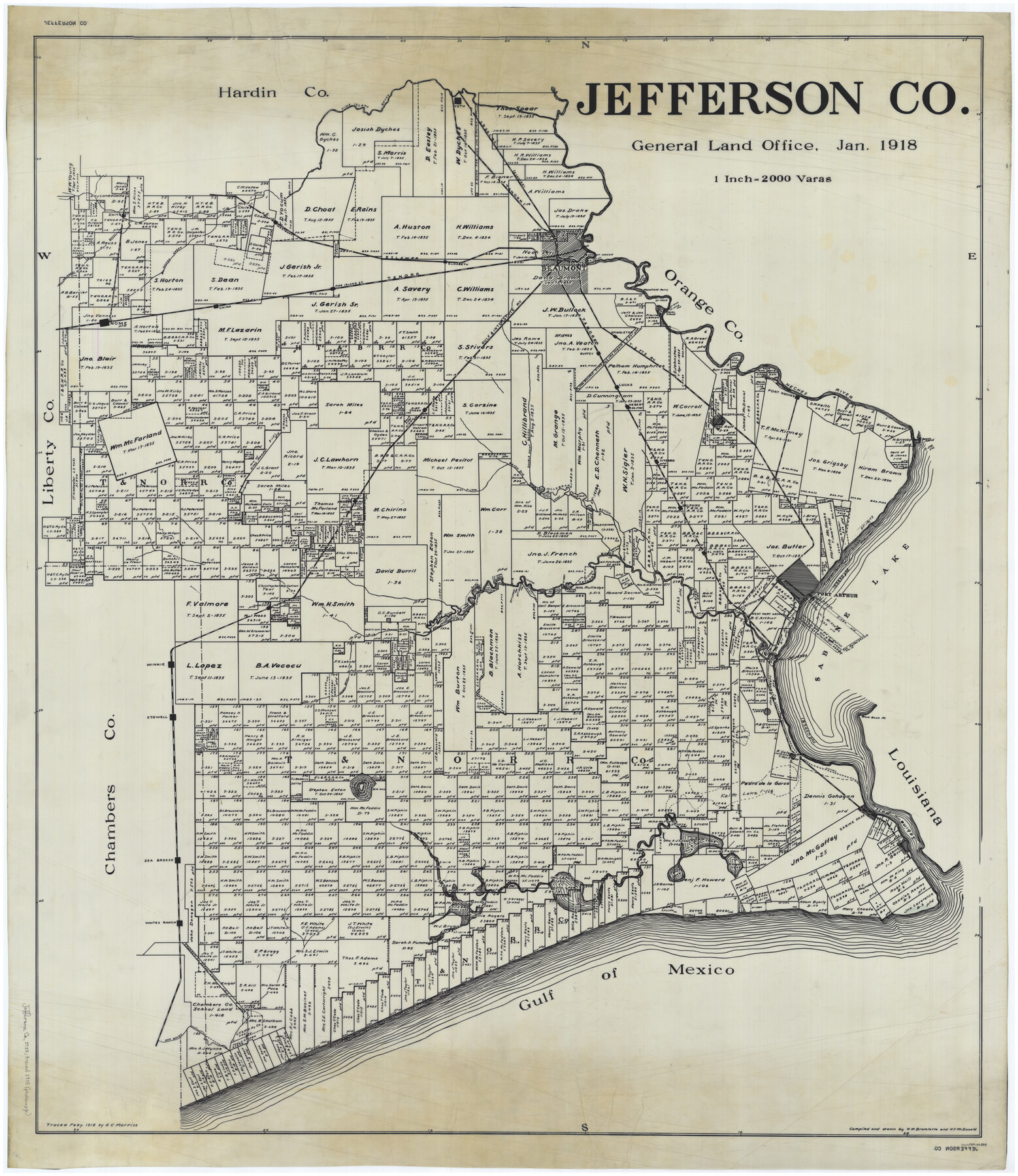
Jefferson Co.
-
Map/Doc
66884
-
Collection
General Map Collection
-
Object Dates
1918 (Creation Date)
-
People and Organizations
Texas General Land Office (Publisher)
H.F. McDonald (Compiler)
H.M. Bramlette (Compiler)
H.M. Bramlette (Draftsman)
H.F. McDonald (Draftsman)
-
Counties
Jefferson
-
Subjects
County
-
Height x Width
47.1 x 41.0 inches
119.6 x 104.1 cm
-
Comments
Traced in February 1918 by G. C. Morriss.
Part of: General Map Collection
Flight Mission No. CUG-3P, Frame 30, Kleberg County

Print $20.00
- Digital $50.00
Flight Mission No. CUG-3P, Frame 30, Kleberg County
1956
Size 18.5 x 22.2 inches
Map/Doc 86235
Flight Mission No. DAG-21K, Frame 103, Matagorda County

Print $20.00
- Digital $50.00
Flight Mission No. DAG-21K, Frame 103, Matagorda County
1952
Size 18.7 x 22.3 inches
Map/Doc 86431
[Texas Department of Corrections Prison Farm Locations]
![78638, [Texas Department of Corrections Prison Farm Locations], General Map Collection](https://historictexasmaps.com/wmedia_w700/maps/78638.tif.jpg)
Print $40.00
- Digital $50.00
[Texas Department of Corrections Prison Farm Locations]
Size 43.0 x 54.0 inches
Map/Doc 78638
San Saba County

Print $20.00
- Digital $50.00
San Saba County
1918
Size 46.8 x 41.2 inches
Map/Doc 63022
Montgomery County Working Sketch 50

Print $20.00
- Digital $50.00
Montgomery County Working Sketch 50
1959
Size 25.3 x 21.9 inches
Map/Doc 71157
St. Louis, Arkansas & Texas R'y, Lufkin Branch, Formerly the Kansas & Gulf Short Line

Print $20.00
- Digital $50.00
St. Louis, Arkansas & Texas R'y, Lufkin Branch, Formerly the Kansas & Gulf Short Line
1888
Size 10.5 x 42.8 inches
Map/Doc 64271
Flight Mission No. CGI-4N, Frame 29, Cameron County

Print $20.00
- Digital $50.00
Flight Mission No. CGI-4N, Frame 29, Cameron County
1954
Size 18.6 x 22.4 inches
Map/Doc 84662
Brewster County Working Sketch 73

Print $20.00
- Digital $50.00
Brewster County Working Sketch 73
1965
Size 24.0 x 32.1 inches
Map/Doc 67673
Brooks County Boundary File 1b

Print $20.00
- Digital $50.00
Brooks County Boundary File 1b
Size 42.2 x 6.6 inches
Map/Doc 50837
Newton County Boundary File 1

Print $4.00
- Digital $50.00
Newton County Boundary File 1
Size 14.3 x 8.8 inches
Map/Doc 57614
Flight Mission No. DAG-18K, Frame 181, Matagorda County

Print $20.00
- Digital $50.00
Flight Mission No. DAG-18K, Frame 181, Matagorda County
1952
Size 15.9 x 15.9 inches
Map/Doc 86373
Henderson County Sketch File 17

Print $40.00
- Digital $50.00
Henderson County Sketch File 17
Size 14.2 x 14.6 inches
Map/Doc 26361
You may also like
Map of Brown County

Print $20.00
- Digital $50.00
Map of Brown County
Size 25.4 x 23.5 inches
Map/Doc 3340
Map showing lands acquired for reservoir purposes in connection with Lake Worth and the boundary of territory annexed to the City of Fort Worth, Texas

Print $40.00
- Digital $50.00
Map showing lands acquired for reservoir purposes in connection with Lake Worth and the boundary of territory annexed to the City of Fort Worth, Texas
Size 46.6 x 59.6 inches
Map/Doc 62210
[Surveys in Austin's Colony along the Brazos River and Oyster Creek]
![206, [Surveys in Austin's Colony along the Brazos River and Oyster Creek], General Map Collection](https://historictexasmaps.com/wmedia_w700/maps/206.tif.jpg)
Print $20.00
- Digital $50.00
[Surveys in Austin's Colony along the Brazos River and Oyster Creek]
1824
Size 23.1 x 17.2 inches
Map/Doc 206
The Republic County of Matagorda. September 17, 1838

Print $20.00
The Republic County of Matagorda. September 17, 1838
2020
Size 21.0 x 21.7 inches
Map/Doc 96217
Right-of-way & Track Map Dawson Railway Operated by the El Paso & Southwestern Company Station 1867+09.6 to Station 360+75.4

Print $40.00
- Digital $50.00
Right-of-way & Track Map Dawson Railway Operated by the El Paso & Southwestern Company Station 1867+09.6 to Station 360+75.4
1910
Size 56.9 x 24.7 inches
Map/Doc 89659
[East half of Travis County]
![75802, [East half of Travis County], Maddox Collection](https://historictexasmaps.com/wmedia_w700/maps/75802.tif.jpg)
Print $20.00
- Digital $50.00
[East half of Travis County]
Size 42.5 x 29.8 inches
Map/Doc 75802
Township No. 5 South Range No. 9 West of the Indian Meridian

Print $20.00
- Digital $50.00
Township No. 5 South Range No. 9 West of the Indian Meridian
1874
Size 19.2 x 24.4 inches
Map/Doc 75167
Flight Mission No. BRE-2P, Frame 103, Nueces County

Print $20.00
- Digital $50.00
Flight Mission No. BRE-2P, Frame 103, Nueces County
1956
Size 18.5 x 22.2 inches
Map/Doc 86788
[I. & G. N. Block 1 and surroundings]
![91539, [I. & G. N. Block 1 and surroundings], Twichell Survey Records](https://historictexasmaps.com/wmedia_w700/maps/91539-1.tif.jpg)
Print $3.00
- Digital $50.00
[I. & G. N. Block 1 and surroundings]
1892
Size 11.9 x 17.2 inches
Map/Doc 91539
Kerr County Boundary File 5

Print $8.00
- Digital $50.00
Kerr County Boundary File 5
Size 14.2 x 8.7 inches
Map/Doc 64818
Washington County Sketch File 5

Print $4.00
- Digital $50.00
Washington County Sketch File 5
Size 8.0 x 7.0 inches
Map/Doc 39652
Conway, Carson County, Texas

Print $20.00
- Digital $50.00
Conway, Carson County, Texas
Size 17.2 x 22.3 inches
Map/Doc 90227