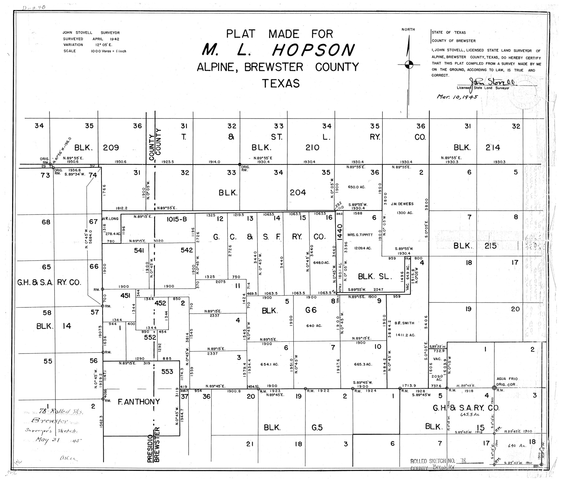
Brewster County Rolled Sketch 78
Plat made for M.L. Hopson, Alpine, Brewster County, Texas
-
Map/Doc
5243
-
Collection
General Map Collection
-
Object Dates
1945/3/10 (Creation Date)
1945/5/31 (File Date)
1942 (Survey Date)
-
People and Organizations
John Stovell (Surveyor/Engineer)
-
Counties
Brewster
-
Subjects
Surveying Rolled Sketch
-
Height x Width
19.8 x 28.0 inches
50.3 x 71.1 cm
-
Scale
1" = 1000 varas
Part of: General Map Collection
Morris County Rolled Sketch 2A

Print $20.00
- Digital $50.00
Morris County Rolled Sketch 2A
Size 13.3 x 19.0 inches
Map/Doc 10232
Upton County Working Sketch 29

Print $40.00
- Digital $50.00
Upton County Working Sketch 29
1956
Size 50.6 x 36.0 inches
Map/Doc 69525
Flight Mission No. DQN-5K, Frame 79, Calhoun County

Print $20.00
- Digital $50.00
Flight Mission No. DQN-5K, Frame 79, Calhoun County
1953
Size 18.5 x 22.2 inches
Map/Doc 84412
Real County Sketch File 17

Print $6.00
- Digital $50.00
Real County Sketch File 17
1942
Size 5.6 x 4.3 inches
Map/Doc 35073
Map of Galveston Harbor and City

Print $40.00
- Digital $50.00
Map of Galveston Harbor and City
1850
Size 31.0 x 52.0 inches
Map/Doc 69856
Midland County Working Sketch 4

Print $20.00
- Digital $50.00
Midland County Working Sketch 4
Size 20.3 x 44.3 inches
Map/Doc 70984
Railroad Track Map, H&TCRRCo., Falls County, Texas

Print $4.00
- Digital $50.00
Railroad Track Map, H&TCRRCo., Falls County, Texas
1918
Size 11.8 x 18.6 inches
Map/Doc 62836
Eastland County Sketch File 15

Print $2.00
- Digital $50.00
Eastland County Sketch File 15
1882
Size 11.4 x 8.6 inches
Map/Doc 21599
Flight Mission No. CRE-2R, Frame 166, Jackson County

Print $20.00
- Digital $50.00
Flight Mission No. CRE-2R, Frame 166, Jackson County
1956
Size 18.5 x 22.2 inches
Map/Doc 85376
Flight Mission No. CRC-3R, Frame 200, Chambers County

Print $20.00
- Digital $50.00
Flight Mission No. CRC-3R, Frame 200, Chambers County
1956
Size 18.6 x 22.2 inches
Map/Doc 84855
Brewster County Rolled Sketch 99

Print $20.00
- Digital $50.00
Brewster County Rolled Sketch 99
1953
Size 26.6 x 22.4 inches
Map/Doc 5255
Austin County Working Sketch 8

Print $20.00
- Digital $50.00
Austin County Working Sketch 8
1992
Size 28.7 x 31.6 inches
Map/Doc 67249
You may also like
Edwards County Sketch File 27

Print $6.00
- Digital $50.00
Edwards County Sketch File 27
1913
Size 10.5 x 16.5 inches
Map/Doc 21755
Jefferson County Rolled Sketch 56

Print $20.00
- Digital $50.00
Jefferson County Rolled Sketch 56
1953
Size 32.1 x 43.8 inches
Map/Doc 6406
Brewster County Rolled Sketch 114

Print $20.00
- Digital $50.00
Brewster County Rolled Sketch 114
1964
Size 11.9 x 18.3 inches
Map/Doc 5280
Hall County Sketch File 33

Print $16.00
- Digital $50.00
Hall County Sketch File 33
1912
Size 11.4 x 8.7 inches
Map/Doc 24874
Crane County Rolled Sketch 23

Print $20.00
- Digital $50.00
Crane County Rolled Sketch 23
2002
Size 23.9 x 34.3 inches
Map/Doc 76426
Webb County Rolled Sketch 54

Print $20.00
- Digital $50.00
Webb County Rolled Sketch 54
1935
Size 24.7 x 18.8 inches
Map/Doc 8206
Plat of Jasper, Sabine, San Augustine, Shelby, Harrison and South Part of Nacogdoches Counties

Print $2.00
- Digital $50.00
Plat of Jasper, Sabine, San Augustine, Shelby, Harrison and South Part of Nacogdoches Counties
1841
Size 13.7 x 9.2 inches
Map/Doc 3174
Concho County Sketch File 4

Print $2.00
- Digital $50.00
Concho County Sketch File 4
1858
Size 8.0 x 10.1 inches
Map/Doc 82523
Lynn County Sketch File 1

Print $8.00
- Digital $50.00
Lynn County Sketch File 1
1892
Size 14.0 x 8.8 inches
Map/Doc 30443
[Block XR, Capitol Leagues 161, 162, 164, 174, 178, 179, and 180]
![90729, [Block XR, Capitol Leagues 161, 162, 164, 174, 178, 179, and 180], Twichell Survey Records](https://historictexasmaps.com/wmedia_w700/maps/90729-1.tif.jpg)
Print $20.00
- Digital $50.00
[Block XR, Capitol Leagues 161, 162, 164, 174, 178, 179, and 180]
1908
Size 13.1 x 21.6 inches
Map/Doc 90729
Current Miscellaneous File 102

Print $611.00
- Digital $50.00
Current Miscellaneous File 102
Size 11.5 x 7.1 inches
Map/Doc 74379
Medina County Sketch File 11

Print $14.00
- Digital $50.00
Medina County Sketch File 11
1907
Size 10.4 x 6.6 inches
Map/Doc 31461