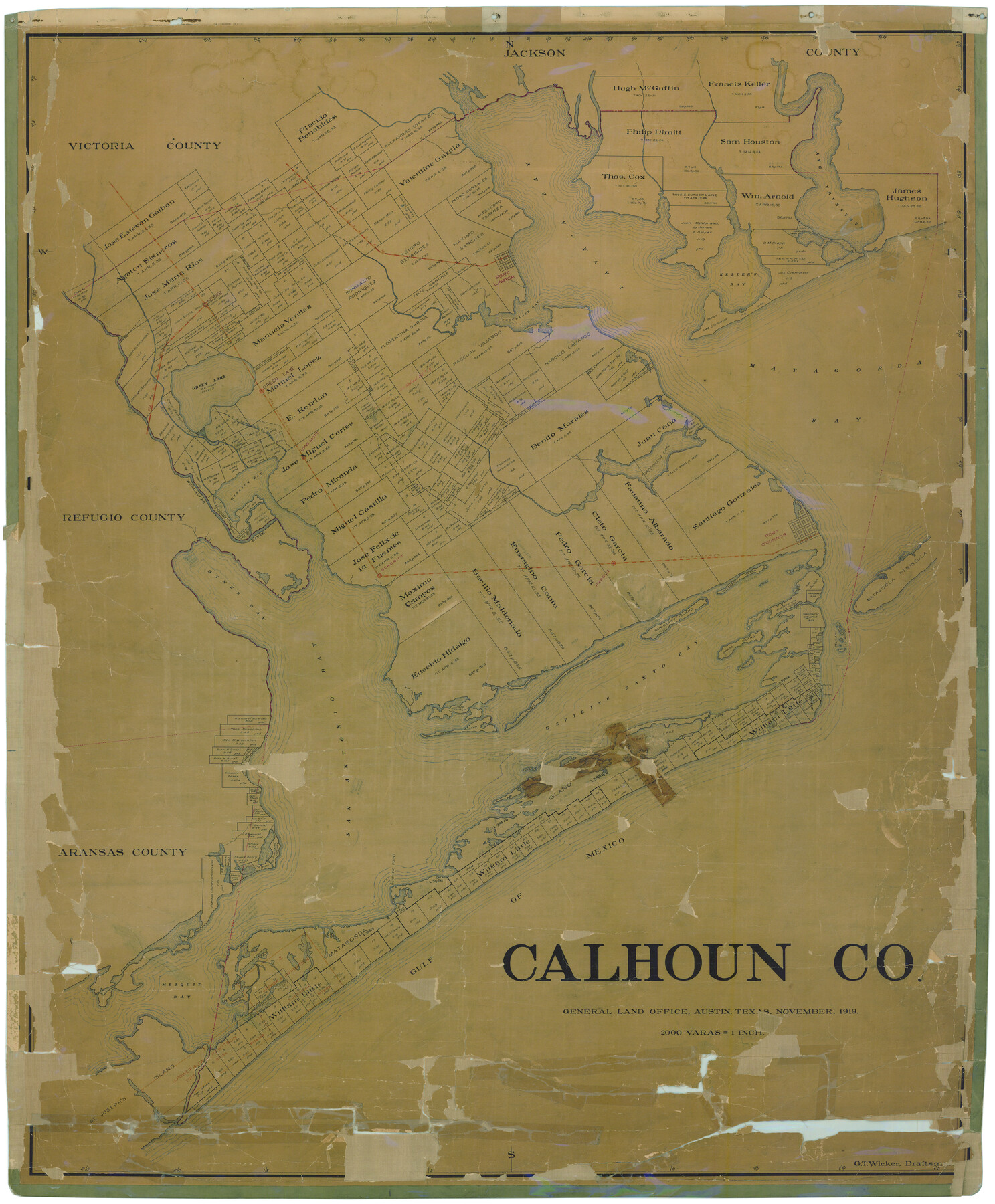
Calhoun Co.
-
Map/Doc
4788
-
Collection
General Map Collection
-
Object Dates
11/1919 (Creation Date)
-
People and Organizations
George T. Wicker (Draftsman)
-
Counties
Calhoun
-
Subjects
County
-
Height x Width
48.7 x 40.1 inches
123.7 x 101.9 cm
-
Comments
Conservation funded in 2006 by Friends of The Texas General Land Office.
-
Features
Pelican Islands
Matagorda Peninsula
Bayucos Island
Saluria
Blackberry Island
Dew-Berry [sic] Island
Hynes Bay
Long Island
Espiritu Santo Bay
Grass Island
Port O'Connor
San Antonio Bay
Pringes Lake
Matagorda Light[house]
Shell Island
Panther Point
Gulf of Mexico
Matagorda Island
Mezquit [sic] Bay
St. Joseph's Island
Smuggler's Bayou
Lavaca Bay
GH&SA
Keller's Bay
Port Lavaca
Heyser
Chocolate Bay
Green Lake
Green Lake
Hog Bayou
Karankawa Bay
SLB&M
Long Mott
Matagorda Bay
Powderhorn Lake
Mission Bay
Guadalupe River
Sea Drift
Prague
Part of: General Map Collection
Ward County Rolled Sketch 7

Print $40.00
- Digital $50.00
Ward County Rolled Sketch 7
1907
Size 33.9 x 91.0 inches
Map/Doc 10103
Taylor County Rolled Sketch 21

Print $20.00
- Digital $50.00
Taylor County Rolled Sketch 21
Size 31.5 x 40.5 inches
Map/Doc 9985
Cherokee County Working Sketch 7

Print $20.00
- Digital $50.00
Cherokee County Working Sketch 7
1954
Size 22.2 x 22.7 inches
Map/Doc 67962
Kimble County Rolled Sketch 12

Print $20.00
- Digital $50.00
Kimble County Rolled Sketch 12
Size 24.6 x 26.2 inches
Map/Doc 6507
Limestone County Working Sketch 24

Print $20.00
- Digital $50.00
Limestone County Working Sketch 24
1980
Size 28.9 x 31.6 inches
Map/Doc 70574
Midland County Rolled Sketch 3

Print $40.00
- Digital $50.00
Midland County Rolled Sketch 3
Size 71.7 x 24.4 inches
Map/Doc 9514
Harris County Historic Topographic 9

Print $20.00
- Digital $50.00
Harris County Historic Topographic 9
1916
Size 14.6 x 24.0 inches
Map/Doc 65819
Reeves County Working Sketch 14

Print $20.00
- Digital $50.00
Reeves County Working Sketch 14
1960
Size 26.5 x 24.9 inches
Map/Doc 63457
Aransas County Working Sketch 9

Print $20.00
- Digital $50.00
Aransas County Working Sketch 9
1947
Size 22.5 x 28.0 inches
Map/Doc 67176

Index sheet to accompany map of survey for connecting the inland waters along margin of the Gulf of Mexico from Donaldsonville in Louisiana to the Rio Grande River in Texas

Print $20.00
- Digital $50.00
Index sheet to accompany map of survey for connecting the inland waters along margin of the Gulf of Mexico from Donaldsonville in Louisiana to the Rio Grande River in Texas
Size 18.2 x 27.4 inches
Map/Doc 72690
Angelina County Working Sketch 39

Print $20.00
- Digital $50.00
Angelina County Working Sketch 39
1959
Size 25.6 x 30.0 inches
Map/Doc 67122
You may also like
Panola County Sketch File 21

Print $10.00
- Digital $50.00
Panola County Sketch File 21
Size 11.2 x 8.7 inches
Map/Doc 33487
Hockley County Sketch Mineral Application Number 38245

Print $20.00
- Digital $50.00
Hockley County Sketch Mineral Application Number 38245
1946
Size 40.6 x 18.5 inches
Map/Doc 92243
Hidalgo County Working Sketch 10

Print $40.00
- Digital $50.00
Hidalgo County Working Sketch 10
2011
Size 59.9 x 29.5 inches
Map/Doc 89998
Township No. 2 South Range No. 19 West of the Indian Meridian

Print $20.00
- Digital $50.00
Township No. 2 South Range No. 19 West of the Indian Meridian
1875
Size 19.2 x 24.8 inches
Map/Doc 75181
Wilbarger County Aerial Photograph Index Sheet 3

Print $20.00
- Digital $50.00
Wilbarger County Aerial Photograph Index Sheet 3
1950
Size 22.5 x 18.9 inches
Map/Doc 83752
Lee County Working Sketch 5

Print $20.00
- Digital $50.00
Lee County Working Sketch 5
1975
Size 38.5 x 36.2 inches
Map/Doc 70384
Marion County Working Sketch 25

Print $20.00
- Digital $50.00
Marion County Working Sketch 25
1968
Size 24.8 x 28.1 inches
Map/Doc 70801
Hemphill County Rolled Sketch 7

Print $20.00
- Digital $50.00
Hemphill County Rolled Sketch 7
1902
Size 21.8 x 25.4 inches
Map/Doc 6189
Aransas County Rolled Sketch 27E

Print $20.00
- Digital $50.00
Aransas County Rolled Sketch 27E
1958
Size 30.2 x 30.9 inches
Map/Doc 8419
Randall County Sketch File 4

Print $20.00
- Digital $50.00
Randall County Sketch File 4
1903
Size 35.6 x 13.4 inches
Map/Doc 12207
Liberty County

Print $20.00
- Digital $50.00
Liberty County
1882
Size 26.1 x 24.8 inches
Map/Doc 3813
Real County Working Sketch 21

Print $20.00
- Digital $50.00
Real County Working Sketch 21
1944
Size 24.8 x 35.7 inches
Map/Doc 71913