Martin County Sketch File 1
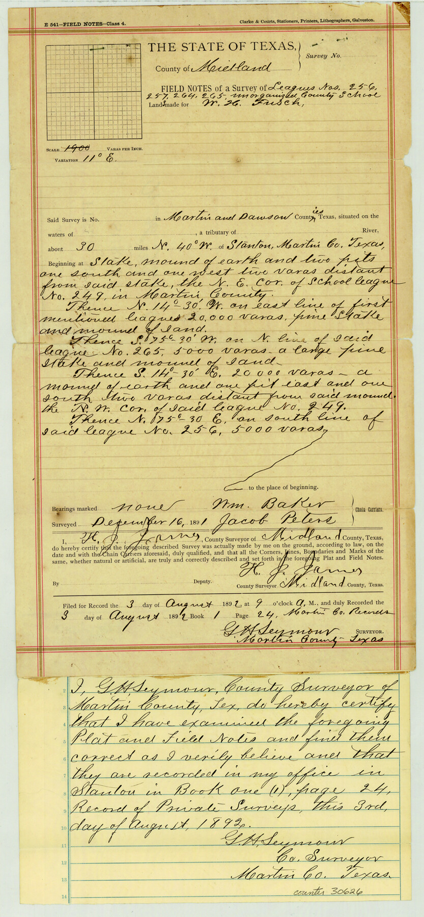
[Sketch and field notes of unorganized county School Leagues]
-
Map/Doc
30626
-
Collection
General Map Collection
-
Object Dates
8/10/1892 (File Date)
8/5/1892 (Correspondence Date)
-
People and Organizations
G.H. Seymour (Surveyor/Engineer)
William Baker (Chainman/Field Personnel)
Jacob Peters (Chainman/Field Personnel)
H.J. James (Surveyor/Engineer)
-
Counties
Martin Dawson Gaines Andrews
-
Subjects
Surveying Sketch File
-
Height x Width
19.3 x 8.9 inches
49.0 x 22.6 cm
-
Medium
paper, print with manuscript additions
-
Scale
1:4000
Part of: General Map Collection
Matagorda County Working Sketch 23

Print $20.00
- Digital $50.00
Matagorda County Working Sketch 23
1968
Size 27.4 x 35.8 inches
Map/Doc 70881
Map of Ferrocarriles Nacionales de Mexico (National Railways of Mexico), Interoceanic Railway of Mexico, Vera Cruz to Isthmus Railroad, Pan-American Railroad, Texas-Mexican Railway

Print $20.00
- Digital $50.00
Map of Ferrocarriles Nacionales de Mexico (National Railways of Mexico), Interoceanic Railway of Mexico, Vera Cruz to Isthmus Railroad, Pan-American Railroad, Texas-Mexican Railway
Size 9.4 x 16.1 inches
Map/Doc 95744
Jasper County Working Sketch 7

Print $20.00
- Digital $50.00
Jasper County Working Sketch 7
1914
Size 24.2 x 26.3 inches
Map/Doc 66469
Childress County Rolled Sketch 8B

Print $20.00
- Digital $50.00
Childress County Rolled Sketch 8B
Size 13.3 x 18.8 inches
Map/Doc 5444
Sutton County

Print $40.00
- Digital $50.00
Sutton County
1898
Size 41.1 x 58.3 inches
Map/Doc 78392
Flight Mission No. BRE-2P, Frame 67, Nueces County

Print $20.00
- Digital $50.00
Flight Mission No. BRE-2P, Frame 67, Nueces County
1956
Size 18.5 x 22.3 inches
Map/Doc 86762
Flight Mission No. CUG-1P, Frame 161, Kleberg County

Print $20.00
- Digital $50.00
Flight Mission No. CUG-1P, Frame 161, Kleberg County
1956
Size 18.5 x 22.3 inches
Map/Doc 86168
Topographical Map of the Rio Grande, Sheet No. 19

Print $20.00
- Digital $50.00
Topographical Map of the Rio Grande, Sheet No. 19
1912
Map/Doc 89543
Zavala County Working Sketch 27

Print $20.00
- Digital $50.00
Zavala County Working Sketch 27
1990
Size 22.3 x 27.5 inches
Map/Doc 62102
Dimmit County Sketch File 10

Print $20.00
- Digital $50.00
Dimmit County Sketch File 10
Size 23.5 x 22.6 inches
Map/Doc 11338
Refugio County Boundary File 4

Print $28.00
- Digital $50.00
Refugio County Boundary File 4
Size 14.0 x 8.8 inches
Map/Doc 58251
San Jacinto County Rolled Sketch 5

Print $20.00
- Digital $50.00
San Jacinto County Rolled Sketch 5
Size 13.7 x 18.6 inches
Map/Doc 8386
You may also like
Val Verde County Rolled Sketch 47

Print $20.00
- Digital $50.00
Val Verde County Rolled Sketch 47
Size 17.4 x 23.0 inches
Map/Doc 49466
Goliad County Working Sketch 4

Print $20.00
- Digital $50.00
Goliad County Working Sketch 4
1920
Size 30.5 x 30.0 inches
Map/Doc 63194
Presidio County Rolled Sketch 35

Print $20.00
- Digital $50.00
Presidio County Rolled Sketch 35
Size 44.7 x 32.1 inches
Map/Doc 9774
Clay County Sketch File 38a

Print $6.00
- Digital $50.00
Clay County Sketch File 38a
1939
Size 14.3 x 8.8 inches
Map/Doc 18469
Stonewall County

Print $20.00
- Digital $50.00
Stonewall County
1902
Size 39.6 x 38.5 inches
Map/Doc 63049
PSL Field Notes for Blocks C36 and C37 in Gaines and Terry Counties, Block C38 in Dawson, Gaines, and Terry Counties, Blocks C39 and C41 in Dawson and Terry Counties, Block K in Yoakum and Terry Counties

PSL Field Notes for Blocks C36 and C37 in Gaines and Terry Counties, Block C38 in Dawson, Gaines, and Terry Counties, Blocks C39 and C41 in Dawson and Terry Counties, Block K in Yoakum and Terry Counties
Map/Doc 81674
Flight Mission No. CGI-4N, Frame 178, Cameron County

Print $20.00
- Digital $50.00
Flight Mission No. CGI-4N, Frame 178, Cameron County
1955
Size 18.6 x 22.3 inches
Map/Doc 84681
Flight Mission No. CRC-1R, Frame 94, Chambers County

Print $20.00
- Digital $50.00
Flight Mission No. CRC-1R, Frame 94, Chambers County
1956
Size 18.8 x 22.5 inches
Map/Doc 84709
San Saba County Sketch File 1

Print $46.00
- Digital $50.00
San Saba County Sketch File 1
1854
Size 9.1 x 7.8 inches
Map/Doc 36400
The Judicial District/County of Smith. Abolished, Spring 1842

Print $20.00
The Judicial District/County of Smith. Abolished, Spring 1842
2020
Size 19.6 x 21.7 inches
Map/Doc 96347

Wilson County Working Sketch 11

Print $20.00
- Digital $50.00
Wilson County Working Sketch 11
1980
Size 14.4 x 13.1 inches
Map/Doc 72591