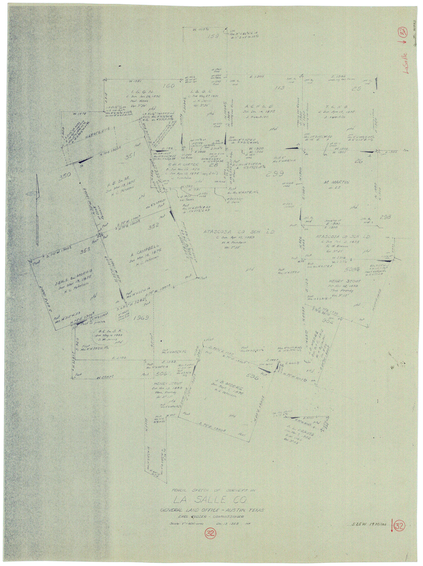
La Salle County Working Sketch 32
-
Map/Doc
70333
-
Collection
General Map Collection
-
Object Dates
12/13/1955 (Creation Date)
-
People and Organizations
Herman Forbes (Draftsman)
-
Counties
La Salle
-
Subjects
Surveying Working Sketch
-
Height x Width
35.8 x 27.1 inches
90.9 x 68.8 cm
-
Scale
1" = 400 varas
Part of: General Map Collection
Sabine County

Print $20.00
- Digital $50.00
Sabine County
1920
Size 43.9 x 34.6 inches
Map/Doc 63014
Leon County Working Sketch 25

Print $20.00
- Digital $50.00
Leon County Working Sketch 25
1968
Size 30.6 x 26.7 inches
Map/Doc 70424
Val Verde County Working Sketch 52

Print $20.00
- Digital $50.00
Val Verde County Working Sketch 52
1956
Size 20.6 x 14.9 inches
Map/Doc 72187
Childress Co.

Print $20.00
- Digital $50.00
Childress Co.
1978
Size 46.2 x 35.0 inches
Map/Doc 73105
[Sketches on Lagoona (sic) Creek, Attascosa (sic) and Laredo Road]
![126, [Sketches on Lagoona (sic) Creek, Attascosa (sic) and Laredo Road], General Map Collection](https://historictexasmaps.com/wmedia_w700/maps/126.tif.jpg)
Print $20.00
- Digital $50.00
[Sketches on Lagoona (sic) Creek, Attascosa (sic) and Laredo Road]
1841
Size 18.0 x 13.5 inches
Map/Doc 126
Harris County Working Sketch 72

Print $20.00
- Digital $50.00
Harris County Working Sketch 72
1958
Size 24.9 x 43.6 inches
Map/Doc 65964
Oso Creek, Rodd Field (P-1) Sheet

Print $20.00
- Digital $50.00
Oso Creek, Rodd Field (P-1) Sheet
1942
Size 33.2 x 34.0 inches
Map/Doc 65096
Liberty County Rolled Sketch N

Print $20.00
- Digital $50.00
Liberty County Rolled Sketch N
Size 44.7 x 38.5 inches
Map/Doc 10180
San Jacinto County Rolled Sketch 10B

Print $40.00
- Digital $50.00
San Jacinto County Rolled Sketch 10B
1944
Size 76.5 x 43.2 inches
Map/Doc 9883
Wood County Working Sketch 8

Print $20.00
- Digital $50.00
Wood County Working Sketch 8
1943
Size 27.7 x 25.2 inches
Map/Doc 62008
Roberts County

Print $20.00
- Digital $50.00
Roberts County
1932
Size 41.9 x 38.0 inches
Map/Doc 73275
Hudspeth County Rolled Sketch 36

Print $20.00
- Digital $50.00
Hudspeth County Rolled Sketch 36
1952
Size 30.8 x 19.9 inches
Map/Doc 6249
You may also like
Atascosa County Sketch File 27d

Print $8.00
- Digital $50.00
Atascosa County Sketch File 27d
1876
Size 10.9 x 8.9 inches
Map/Doc 13812
Pecos County Rolled Sketch 46

Print $3.00
- Digital $50.00
Pecos County Rolled Sketch 46
1913
Size 13.4 x 9.7 inches
Map/Doc 7224
Schleicher County Rolled Sketch 7

Print $20.00
- Digital $50.00
Schleicher County Rolled Sketch 7
Size 32.5 x 37.9 inches
Map/Doc 9904
Preliminary Chart of Galveston Bay, Texas

Print $20.00
- Digital $50.00
Preliminary Chart of Galveston Bay, Texas
1855
Size 20.9 x 17.5 inches
Map/Doc 69868
In the Supreme Court of the United States The State of Oklahoma, Complainant vs. The State of Texas, Defendant, The United States of America, Intervener - 1920

Print $20.00
- Digital $50.00
In the Supreme Court of the United States The State of Oklahoma, Complainant vs. The State of Texas, Defendant, The United States of America, Intervener - 1920
1920
Size 39.4 x 35.7 inches
Map/Doc 75264
Parker County Working Sketch 23

Print $20.00
- Digital $50.00
Parker County Working Sketch 23
2007
Map/Doc 87924
Madison County Working Sketch 5

Print $20.00
- Digital $50.00
Madison County Working Sketch 5
1981
Size 24.0 x 24.1 inches
Map/Doc 70767
Lipscomb County

Print $20.00
- Digital $50.00
Lipscomb County
1878
Size 18.1 x 16.4 inches
Map/Doc 3816
Ector County Boundary File 5

Print $12.00
- Digital $50.00
Ector County Boundary File 5
Size 14.3 x 8.8 inches
Map/Doc 52847
[Texas Central Railway through Callahan County]
![64240, [Texas Central Railway through Callahan County], General Map Collection](https://historictexasmaps.com/wmedia_w700/maps/64240-1.tif.jpg)
Print $40.00
- Digital $50.00
[Texas Central Railway through Callahan County]
Size 24.6 x 86.3 inches
Map/Doc 64240
Howard County Working Sketch 8

Print $20.00
- Digital $50.00
Howard County Working Sketch 8
1956
Size 25.3 x 31.3 inches
Map/Doc 66275
Map of Chambers County, Texas

Print $20.00
- Digital $50.00
Map of Chambers County, Texas
1879
Size 26.3 x 30.7 inches
Map/Doc 695