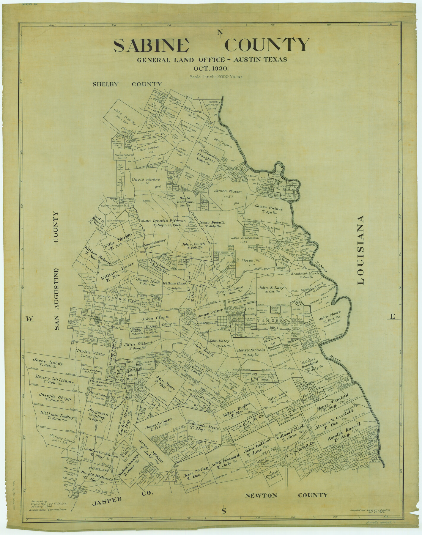
Sabine County
-
Map/Doc
63014
-
Collection
General Map Collection
-
Object Dates
1920/10/27 (Creation Date)
-
People and Organizations
Texas General Land Office (Publisher)
John D. Hedick (Compiler)
John D. Hedick (Draftsman)
-
Counties
Sabine
-
Subjects
County
-
Height x Width
43.9 x 34.6 inches
111.5 x 87.9 cm
-
Comments
Retraced in January 1944 by Virginia Payne and O. G. Kurio.
Part of: General Map Collection
Crane County Working Sketch 15

Print $20.00
- Digital $50.00
Crane County Working Sketch 15
1946
Size 33.6 x 38.0 inches
Map/Doc 68292
Harris County NRC Article 33.136 Sketch 17

Print $26.00
- Digital $50.00
Harris County NRC Article 33.136 Sketch 17
2011
Size 22.0 x 17.0 inches
Map/Doc 94758
Flight Mission No. CUG-3P, Frame 138, Kleberg County

Print $20.00
- Digital $50.00
Flight Mission No. CUG-3P, Frame 138, Kleberg County
1956
Size 18.6 x 22.4 inches
Map/Doc 86273
Falls County Sketch File 14

Print $40.00
- Digital $50.00
Falls County Sketch File 14
Size 15.9 x 12.9 inches
Map/Doc 22370
Arroyo Colorado, Rio Hondo Sheet

Print $40.00
- Digital $50.00
Arroyo Colorado, Rio Hondo Sheet
1929
Size 35.0 x 52.6 inches
Map/Doc 65129
Terrell County Rolled Sketch 59

Print $20.00
- Digital $50.00
Terrell County Rolled Sketch 59
Size 32.5 x 28.2 inches
Map/Doc 7975
Travis County Sketch File 66

Print $12.00
- Digital $50.00
Travis County Sketch File 66
1950
Size 14.2 x 9.0 inches
Map/Doc 38440
Pecos County Sketch File 45

Print $20.00
- Digital $50.00
Pecos County Sketch File 45
Size 13.8 x 21.7 inches
Map/Doc 12179
Flight Mission No. DAG-17K, Frame 133, Matagorda County

Print $20.00
- Digital $50.00
Flight Mission No. DAG-17K, Frame 133, Matagorda County
1952
Size 18.6 x 22.3 inches
Map/Doc 86350
Gonzales County Sketch File 4

Print $4.00
- Digital $50.00
Gonzales County Sketch File 4
Size 12.6 x 8.0 inches
Map/Doc 24373
Reeves County

Print $40.00
- Digital $50.00
Reeves County
1945
Size 49.4 x 40.8 inches
Map/Doc 95624
Flight Mission No. DIX-5P, Frame 111, Aransas County

Print $20.00
- Digital $50.00
Flight Mission No. DIX-5P, Frame 111, Aransas County
1956
Size 17.6 x 18.0 inches
Map/Doc 83790
You may also like
[Leagues 575, 578, 609, and 616, Blocks T2, T3, and K13]
![91053, [Leagues 575, 578, 609, and 616, Blocks T2, T3, and K13], Twichell Survey Records](https://historictexasmaps.com/wmedia_w700/maps/91053-1.tif.jpg)
Print $20.00
- Digital $50.00
[Leagues 575, 578, 609, and 616, Blocks T2, T3, and K13]
Size 20.5 x 20.0 inches
Map/Doc 91053
Wheelock Second Addition

Print $20.00
- Digital $50.00
Wheelock Second Addition
1952
Size 9.3 x 24.3 inches
Map/Doc 92308
Flight Mission No. CUG-3P, Frame 23, Kleberg County

Print $20.00
- Digital $50.00
Flight Mission No. CUG-3P, Frame 23, Kleberg County
1956
Size 18.5 x 22.3 inches
Map/Doc 86233
Blanco County Working Sketch 30

Print $20.00
- Digital $50.00
Blanco County Working Sketch 30
1971
Size 22.9 x 34.6 inches
Map/Doc 67390
Travis County Sketch File 9

Print $4.00
- Digital $50.00
Travis County Sketch File 9
Size 12.6 x 8.2 inches
Map/Doc 38290
Fredonia or the United States of North-America; including also Cabotia, or the Canadian Provinces; the Western Territory to the Pacific Ocean; and the Northern Part of the Mexican States

Print $20.00
- Digital $50.00
Fredonia or the United States of North-America; including also Cabotia, or the Canadian Provinces; the Western Territory to the Pacific Ocean; and the Northern Part of the Mexican States
1848
Size 26.8 x 39.9 inches
Map/Doc 93879

Flight Mission No. BQY-15M, Frame 8, Harris County

Print $20.00
- Digital $50.00
Flight Mission No. BQY-15M, Frame 8, Harris County
1953
Size 18.7 x 22.4 inches
Map/Doc 85306
McClennan County

Print $20.00
- Digital $50.00
McClennan County
1880
Size 23.6 x 25.4 inches
Map/Doc 4596
Freestone County Sketch File 27

Print $2.00
- Digital $50.00
Freestone County Sketch File 27
1934
Size 11.3 x 8.6 inches
Map/Doc 23098
Harris County Boundary File 39 (14)

Print $30.00
- Digital $50.00
Harris County Boundary File 39 (14)
Size 13.2 x 8.1 inches
Map/Doc 54344
[County Line between Dickens and Kent Counties]
![90938, [County Line between Dickens and Kent Counties], Twichell Survey Records](https://historictexasmaps.com/wmedia_w700/maps/90938-1.tif.jpg)
Print $20.00
- Digital $50.00
[County Line between Dickens and Kent Counties]
1891
Size 42.4 x 7.4 inches
Map/Doc 90938