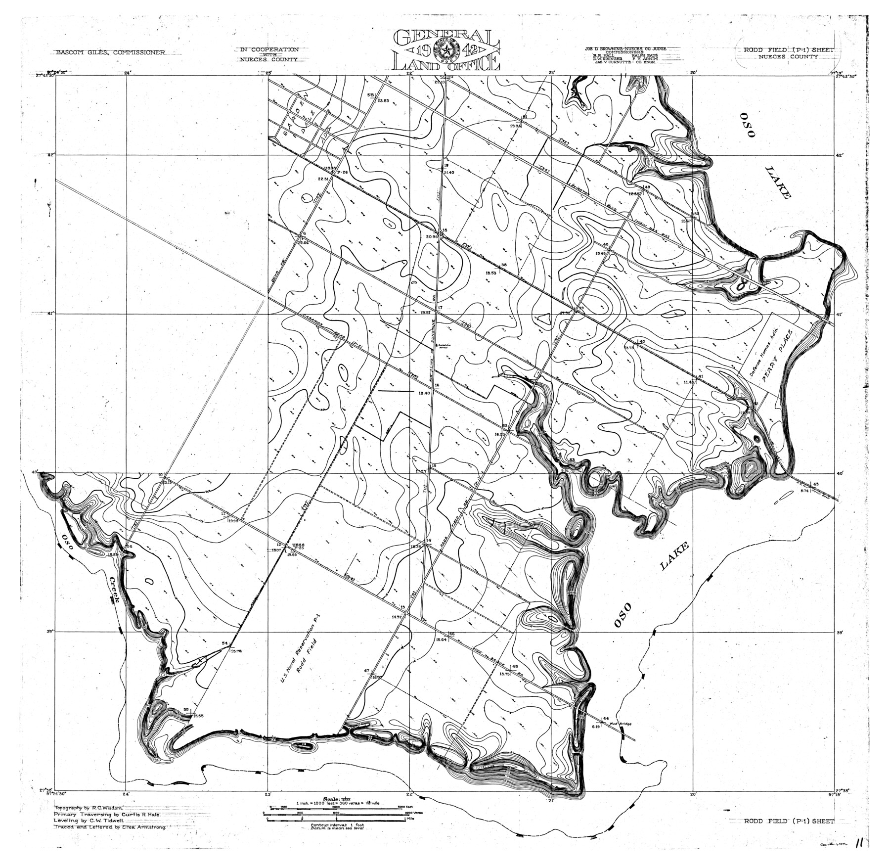
Oso Creek, Rodd Field (P-1) Sheet
-
Map/Doc
65096
-
Collection
General Map Collection
-
Object Dates
1942 (Creation Date)
-
People and Organizations
Texas State Reclamation Department (Publisher)
Eltea Armstrong (Draftsman)
Eltea Armstrong (Compiler)
Curtis R. Hale (Surveyor/Engineer)
R.C. Wisdom (Surveyor/Engineer)
C.W. Tidwell (Surveyor/Engineer)
-
Counties
Nueces
-
Subjects
City River Surveys Topographic
-
Height x Width
33.2 x 34.0 inches
84.3 x 86.4 cm
Part of: General Map Collection
Eastland County Rolled Sketch 24

Print $20.00
- Digital $50.00
Eastland County Rolled Sketch 24
1983
Size 33.5 x 38.0 inches
Map/Doc 8830
Val Verde County Working Sketch 78

Print $40.00
- Digital $50.00
Val Verde County Working Sketch 78
1972
Size 45.3 x 62.1 inches
Map/Doc 72213
Haskell County Rolled Sketch 15A

Print $3.00
- Digital $50.00
Haskell County Rolled Sketch 15A
1991
Size 11.3 x 17.1 inches
Map/Doc 6174
Uvalde County Working Sketch 47

Print $20.00
- Digital $50.00
Uvalde County Working Sketch 47
1979
Size 29.7 x 24.8 inches
Map/Doc 72117
Motley County Sketch File 16 (N)

Print $16.00
- Digital $50.00
Motley County Sketch File 16 (N)
1911
Size 11.0 x 8.6 inches
Map/Doc 32052
Hopkins County Sketch File 12

Print $6.00
- Digital $50.00
Hopkins County Sketch File 12
Size 6.8 x 8.1 inches
Map/Doc 26706
Ward County Rolled Sketch A

Print $40.00
- Digital $50.00
Ward County Rolled Sketch A
Size 42.6 x 56.3 inches
Map/Doc 10099
Pecos County Working Sketch 37

Print $20.00
- Digital $50.00
Pecos County Working Sketch 37
1939
Size 30.0 x 43.0 inches
Map/Doc 71509
Fractional Township No. 7 South Range No. 7 East of the Indian Meridian, Indian Territory

Print $20.00
- Digital $50.00
Fractional Township No. 7 South Range No. 7 East of the Indian Meridian, Indian Territory
1898
Size 19.2 x 24.3 inches
Map/Doc 75212
Panola County Working Sketch 40

Print $20.00
- Digital $50.00
Panola County Working Sketch 40
1995
Map/Doc 71449
Map of that part of Comal County in Bexar District

Print $20.00
- Digital $50.00
Map of that part of Comal County in Bexar District
Size 16.3 x 22.1 inches
Map/Doc 3431
Coryell County Boundary File 4

Print $4.00
- Digital $50.00
Coryell County Boundary File 4
Size 11.2 x 8.7 inches
Map/Doc 51930
You may also like
John Slaughter Ranch

Print $40.00
- Digital $50.00
John Slaughter Ranch
Size 38.0 x 52.7 inches
Map/Doc 89952
Aransas County Rolled Sketch 19A

Print $20.00
- Digital $50.00
Aransas County Rolled Sketch 19A
1979
Size 32.0 x 24.8 inches
Map/Doc 76068
Denton County Sketch File 28

Print $4.00
- Digital $50.00
Denton County Sketch File 28
Size 14.4 x 8.9 inches
Map/Doc 20756
Chambers County Sketch File 16

Print $4.00
- Digital $50.00
Chambers County Sketch File 16
Size 7.9 x 12.7 inches
Map/Doc 17566
Archer County Boundary File 7

Print $10.00
- Digital $50.00
Archer County Boundary File 7
Size 8.2 x 5.2 inches
Map/Doc 50116
Flight Mission No. BRA-7M, Frame 146, Jefferson County

Print $20.00
- Digital $50.00
Flight Mission No. BRA-7M, Frame 146, Jefferson County
1953
Size 16.1 x 16.1 inches
Map/Doc 85540
[Capitol League Lands in SE corner of Lamb County and along the north line of Lamb and Bailey]
![90244, [Capitol League Lands in SE corner of Lamb County and along the north line of Lamb and Bailey], Twichell Survey Records](https://historictexasmaps.com/wmedia_w700/maps/90244-1.tif.jpg)
Print $20.00
- Digital $50.00
[Capitol League Lands in SE corner of Lamb County and along the north line of Lamb and Bailey]
Size 27.7 x 19.7 inches
Map/Doc 90244
Zavala County Sketch File 13

Print $4.00
- Digital $50.00
Zavala County Sketch File 13
1891
Size 14.5 x 9.0 inches
Map/Doc 41306
Liberty County Rolled Sketch M

Print $40.00
- Digital $50.00
Liberty County Rolled Sketch M
1953
Size 23.6 x 56.6 inches
Map/Doc 10651
Somervell County Rolled Sketch B

Print $20.00
- Digital $50.00
Somervell County Rolled Sketch B
Size 18.8 x 19.9 inches
Map/Doc 7792
Chambers County Working Sketch 10

Print $20.00
- Digital $50.00
Chambers County Working Sketch 10
1950
Size 40.1 x 33.0 inches
Map/Doc 67993
Crockett County Working Sketch 48

Print $20.00
- Digital $50.00
Crockett County Working Sketch 48
1938
Size 23.8 x 13.2 inches
Map/Doc 68381