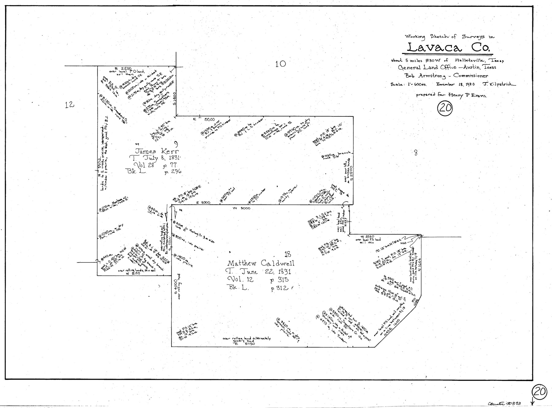
Lavaca County Working Sketch 20
-
Map/Doc
70373
-
Collection
General Map Collection
-
Object Dates
11/18/1980 (Creation Date)
-
People and Organizations
Joan Kilpatrick (Draftsman)
-
Counties
Lavaca
-
Subjects
Surveying Working Sketch
-
Height x Width
19.2 x 26.0 inches
48.8 x 66.0 cm
-
Scale
1" = 600 varas
Part of: General Map Collection
Kerr County Boundary File 2

Print $46.00
- Digital $50.00
Kerr County Boundary File 2
Size 15.6 x 26.5 inches
Map/Doc 55984
Jeff Davis County Sketch File 20

Print $56.00
- Digital $50.00
Jeff Davis County Sketch File 20
1923
Size 11.2 x 8.8 inches
Map/Doc 27978
Dallam County Sketch File 9

Print $40.00
- Digital $50.00
Dallam County Sketch File 9
1914
Size 9.0 x 7.7 inches
Map/Doc 20357
Flight Mission No. CUG-1P, Frame 114, Kleberg County

Print $20.00
- Digital $50.00
Flight Mission No. CUG-1P, Frame 114, Kleberg County
1956
Size 18.5 x 22.1 inches
Map/Doc 86164
[Capitol League Surveys in Hartley County, Texas]
![1766, [Capitol League Surveys in Hartley County, Texas], General Map Collection](https://historictexasmaps.com/wmedia_w700/maps/1766.tif.jpg)
Print $20.00
- Digital $50.00
[Capitol League Surveys in Hartley County, Texas]
1910
Size 19.6 x 27.9 inches
Map/Doc 1766
East Part of Brewster Co.

Print $40.00
- Digital $50.00
East Part of Brewster Co.
1952
Size 48.7 x 29.6 inches
Map/Doc 66734
Fort Bend County Sketch File 15

Print $5.00
- Digital $50.00
Fort Bend County Sketch File 15
Size 11.9 x 12.8 inches
Map/Doc 22925
Flight Mission No. DAG-21K, Frame 29, Matagorda County

Print $20.00
- Digital $50.00
Flight Mission No. DAG-21K, Frame 29, Matagorda County
1952
Size 18.5 x 16.1 inches
Map/Doc 86396
Hall County Sketch File D

Print $8.00
- Digital $50.00
Hall County Sketch File D
1906
Size 14.4 x 8.7 inches
Map/Doc 24792
Flight Mission No. CUG-1P, Frame 108, Kleberg County

Print $20.00
- Digital $50.00
Flight Mission No. CUG-1P, Frame 108, Kleberg County
1956
Size 18.6 x 22.2 inches
Map/Doc 86158
Flight Mission No. DCL-7C, Frame 108, Kenedy County

Print $20.00
- Digital $50.00
Flight Mission No. DCL-7C, Frame 108, Kenedy County
1943
Size 18.3 x 22.2 inches
Map/Doc 86073
Uvalde County Rolled Sketch 10

Print $20.00
- Digital $50.00
Uvalde County Rolled Sketch 10
Size 23.5 x 16.1 inches
Map/Doc 8095
You may also like
Houston County

Print $20.00
- Digital $50.00
Houston County
1868
Size 25.5 x 26.1 inches
Map/Doc 3685
Liberty County Boundary File 1

Print $8.00
- Digital $50.00
Liberty County Boundary File 1
Size 14.2 x 8.9 inches
Map/Doc 56289
Map of the country scouted by Colonels McKenzie and Shafter, Capt. R.P. Wilson and others in the years, 1874 & 1875

Print $20.00
- Digital $50.00
Map of the country scouted by Colonels McKenzie and Shafter, Capt. R.P. Wilson and others in the years, 1874 & 1875
1876
Size 43.0 x 31.8 inches
Map/Doc 62972
Map of Adrian, the New Town in the Panhandle, Oldham County, Texas

Print $20.00
- Digital $50.00
Map of Adrian, the New Town in the Panhandle, Oldham County, Texas
Size 21.5 x 25.8 inches
Map/Doc 92135
Duval County Sketch File 83

Print $20.00
- Digital $50.00
Duval County Sketch File 83
1933
Size 13.7 x 8.8 inches
Map/Doc 21521
Corrected Map of Burnet County or Northern District of Houston County

Print $20.00
- Digital $50.00
Corrected Map of Burnet County or Northern District of Houston County
1845
Size 32.0 x 19.9 inches
Map/Doc 5052
[McLennan County School Land Leagues 3 and 4 and surrounding surveys/blocks]
![90434, [McLennan County School Land Leagues 3 and 4 and surrounding surveys/blocks], Twichell Survey Records](https://historictexasmaps.com/wmedia_w700/maps/90434-1.tif.jpg)
Print $20.00
- Digital $50.00
[McLennan County School Land Leagues 3 and 4 and surrounding surveys/blocks]
Size 12.0 x 14.8 inches
Map/Doc 90434
Hays County Boundary File

Print $120.00
- Digital $50.00
Hays County Boundary File
1947
Size 33.6 x 20.8 inches
Map/Doc 65496
Travis County Rolled Sketch 21

Print $20.00
- Digital $50.00
Travis County Rolled Sketch 21
1941
Size 16.2 x 14.7 inches
Map/Doc 8022
Flight Mission No. CGI-1N, Frame 133, Cameron County

Print $20.00
- Digital $50.00
Flight Mission No. CGI-1N, Frame 133, Cameron County
1955
Size 18.5 x 22.1 inches
Map/Doc 84489
Flight Mission No. CRC-2R, Frame 4, Chambers County

Print $20.00
- Digital $50.00
Flight Mission No. CRC-2R, Frame 4, Chambers County
1956
Size 18.7 x 22.4 inches
Map/Doc 84723
Galveston County

Print $40.00
- Digital $50.00
Galveston County
1939
Size 45.0 x 56.5 inches
Map/Doc 95505