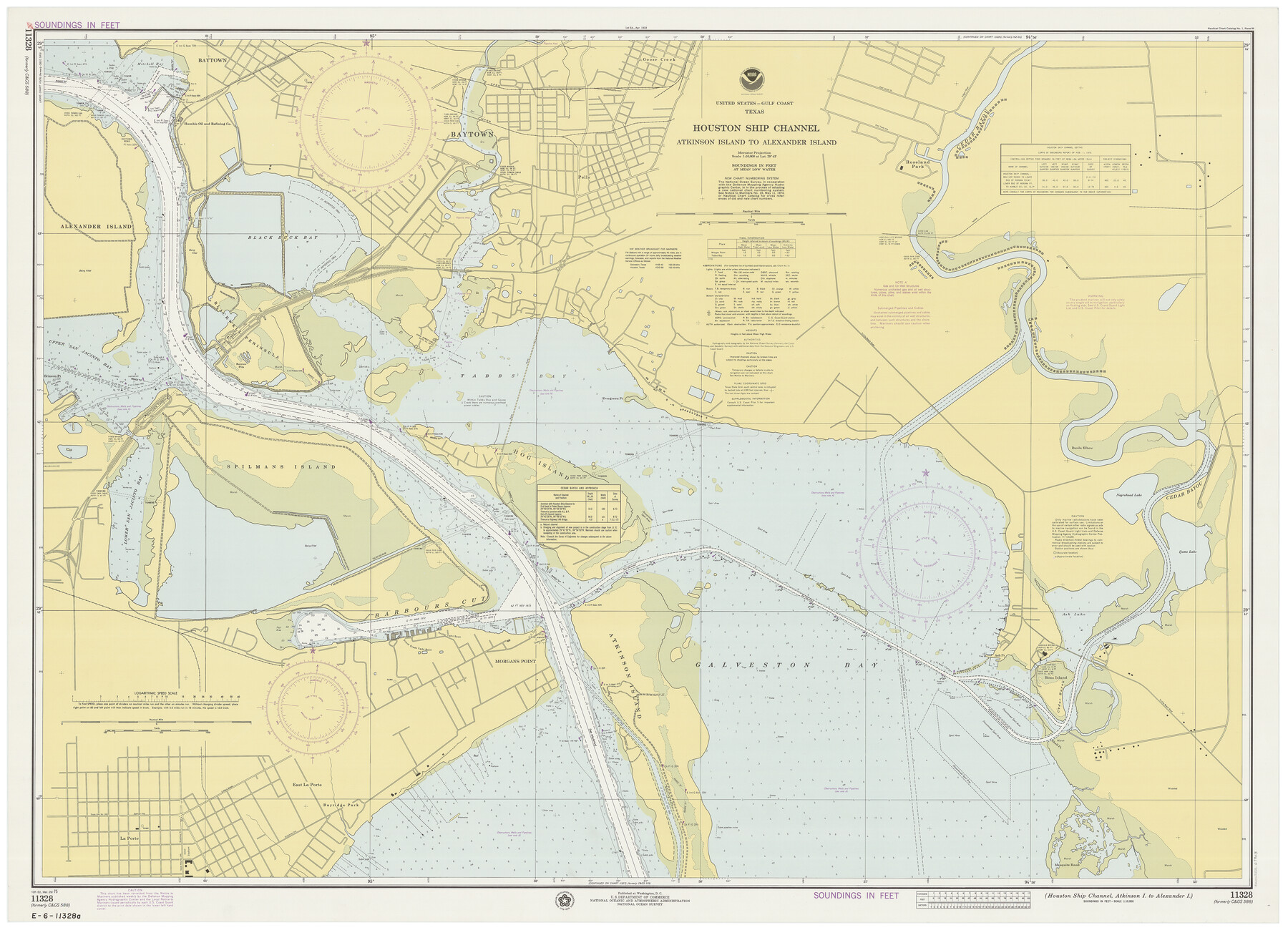
Houston Ship Channel, Atkinson Island to Alexander Island
K-2-588a
-
Map/Doc
69903
-
Collection
General Map Collection
-
Object Dates
3/29/1975 (Creation Date)
-
Counties
Harris Chambers
-
Subjects
Nautical Charts
-
Height x Width
36.2 x 50.4 inches
92.0 x 128.0 cm
Part of: General Map Collection
Hunt County Boundary File 10b

Print $4.00
- Digital $50.00
Hunt County Boundary File 10b
Size 11.3 x 8.9 inches
Map/Doc 55264
Wichita County Boundary File 4

Print $20.00
- Digital $50.00
Wichita County Boundary File 4
Size 12.4 x 38.3 inches
Map/Doc 59914
Bastrop County Working Sketch 14

Print $20.00
- Digital $50.00
Bastrop County Working Sketch 14
1984
Size 24.5 x 23.4 inches
Map/Doc 67314
Willacy County Aerial Photograph Index Sheet 1

Print $20.00
- Digital $50.00
Willacy County Aerial Photograph Index Sheet 1
1940
Size 24.3 x 20.2 inches
Map/Doc 83756
Bandera County Working Sketch 17

Print $20.00
- Digital $50.00
Bandera County Working Sketch 17
1943
Size 21.2 x 27.5 inches
Map/Doc 67613
Flight Mission No. DQO-7K, Frame 107, Galveston County

Print $20.00
- Digital $50.00
Flight Mission No. DQO-7K, Frame 107, Galveston County
1952
Size 18.6 x 22.6 inches
Map/Doc 85122
Gaines County Sketch File 4

Print $4.00
- Digital $50.00
Gaines County Sketch File 4
1902
Size 14.3 x 8.5 inches
Map/Doc 23175
Map of Coryell County

Print $20.00
- Digital $50.00
Map of Coryell County
1863
Size 23.1 x 27.4 inches
Map/Doc 3443
Val Verde County Working Sketch 77

Print $20.00
- Digital $50.00
Val Verde County Working Sketch 77
1972
Size 45.9 x 38.5 inches
Map/Doc 72212
Amistad International Reservoir on Rio Grande 89b

Print $20.00
- Digital $50.00
Amistad International Reservoir on Rio Grande 89b
1950
Size 28.4 x 40.7 inches
Map/Doc 75519

Winkler County Working Sketch 13

Print $20.00
- Digital $50.00
Winkler County Working Sketch 13
1961
Size 39.2 x 41.2 inches
Map/Doc 72607
You may also like
Flight Mission No. CUG-3P, Frame 193, Kleberg County

Print $20.00
- Digital $50.00
Flight Mission No. CUG-3P, Frame 193, Kleberg County
1956
Size 18.4 x 22.3 inches
Map/Doc 86297
Southern Part of Laguna Madre

Print $20.00
- Digital $50.00
Southern Part of Laguna Madre
1960
Size 44.1 x 34.6 inches
Map/Doc 73538
Wharton County Sketch File A1

Print $20.00
- Digital $50.00
Wharton County Sketch File A1
1895
Size 15.6 x 36.4 inches
Map/Doc 12669
Winkler County Working Sketch 7

Print $20.00
- Digital $50.00
Winkler County Working Sketch 7
1958
Size 45.4 x 30.2 inches
Map/Doc 72601
PSF Field Notes for Blocks 42 1/2 and 43 in Culberson and Hudspeth Counties, and Blocks 30 through 41 in Hudspeth County

PSF Field Notes for Blocks 42 1/2 and 43 in Culberson and Hudspeth Counties, and Blocks 30 through 41 in Hudspeth County
Map/Doc 81660
English Field Notes of the Spanish Archives - Books JMH, MCMCHB, TGI

English Field Notes of the Spanish Archives - Books JMH, MCMCHB, TGI
1835
Map/Doc 96547
Medina County Rolled Sketch 7

Print $20.00
- Digital $50.00
Medina County Rolled Sketch 7
1966
Size 36.9 x 21.9 inches
Map/Doc 6741
Lampasas County Rolled Sketch 1

Print $20.00
- Digital $50.00
Lampasas County Rolled Sketch 1
1975
Size 22.0 x 28.2 inches
Map/Doc 6564
Glasscock County Rolled Sketch 18

Print $20.00
- Digital $50.00
Glasscock County Rolled Sketch 18
Size 24.2 x 24.0 inches
Map/Doc 96576
Coast Chart No. 212 - From Latitude 26° 33' to the Rio Grande Texas

Print $20.00
- Digital $50.00
Coast Chart No. 212 - From Latitude 26° 33' to the Rio Grande Texas
1886
Size 27.7 x 18.3 inches
Map/Doc 72828
Orange County Rolled Sketch RG

Print $40.00
- Digital $50.00
Orange County Rolled Sketch RG
1919
Size 32.7 x 61.2 inches
Map/Doc 9654
