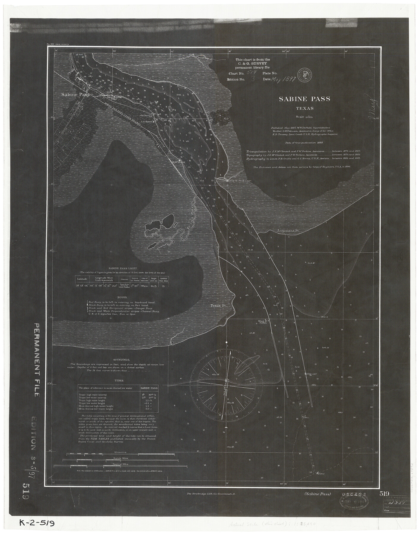
Sabine Pass
K-2-519
-
Map/Doc
69842
-
Collection
General Map Collection
-
Object Dates
1888 (Creation Date)
-
Counties
Jefferson
-
Subjects
Nautical Charts
-
Height x Width
23.2 x 18.5 inches
58.9 x 47.0 cm
Part of: General Map Collection
Coleman County Sketch File 22

Print $10.00
- Digital $50.00
Coleman County Sketch File 22
1871
Size 8.4 x 7.9 inches
Map/Doc 18698
Kinney County Rolled Sketch 12

Print $20.00
- Digital $50.00
Kinney County Rolled Sketch 12
1947
Size 29.2 x 38.9 inches
Map/Doc 6541
Denton County Working Sketch 9

Print $20.00
- Digital $50.00
Denton County Working Sketch 9
1959
Size 33.7 x 37.6 inches
Map/Doc 68614

[Surveys in the Bexar District along the San Antonio River showing the position of the missions]
![125, [Surveys in the Bexar District along the San Antonio River showing the position of the missions], General Map Collection](https://historictexasmaps.com/wmedia_w700/maps/125.tif.jpg)
Print $3.00
- Digital $50.00
[Surveys in the Bexar District along the San Antonio River showing the position of the missions]
1841
Size 11.2 x 16.0 inches
Map/Doc 125
[Del Rio, Texas]
![2070, [Del Rio, Texas], General Map Collection](https://historictexasmaps.com/wmedia_w700/maps/2070-1.tif.jpg)
Print $20.00
- Digital $50.00
[Del Rio, Texas]
1886
Size 24.2 x 34.3 inches
Map/Doc 2070
Archer County Sketch File 20

Print $6.00
- Digital $50.00
Archer County Sketch File 20
1936
Size 11.0 x 8.7 inches
Map/Doc 13655
Hartley County Working Sketch 7

Print $20.00
- Digital $50.00
Hartley County Working Sketch 7
1971
Size 20.1 x 25.1 inches
Map/Doc 66057
[Map of Chicago, Rock Island & Texas Railway through Tarrant County, Texas]
![64412, [Map of Chicago, Rock Island & Texas Railway through Tarrant County, Texas], General Map Collection](https://historictexasmaps.com/wmedia_w700/maps/64412.tif.jpg)
Print $40.00
- Digital $50.00
[Map of Chicago, Rock Island & Texas Railway through Tarrant County, Texas]
1893
Size 22.9 x 122.0 inches
Map/Doc 64412
Duval County Sketch File 79

Print $46.00
- Digital $50.00
Duval County Sketch File 79
1925
Size 14.3 x 9.1 inches
Map/Doc 21469
Texas Gulf Coast Map from the Sabine River to the Rio Grande as subdivided for mineral development

Print $40.00
- Digital $50.00
Texas Gulf Coast Map from the Sabine River to the Rio Grande as subdivided for mineral development
1948
Size 48.9 x 38.0 inches
Map/Doc 2910
Real County Working Sketch 35

Print $20.00
- Digital $50.00
Real County Working Sketch 35
1949
Size 27.7 x 23.6 inches
Map/Doc 71927
You may also like
Carson County Working Sketch 3

Print $20.00
- Digital $50.00
Carson County Working Sketch 3
1922
Size 18.3 x 26.3 inches
Map/Doc 67874
Deaf Smith County Sketch File 1 1/2

Print $20.00
- Digital $50.00
Deaf Smith County Sketch File 1 1/2
Size 20.7 x 17.1 inches
Map/Doc 11302
Live Oak County Rolled Sketch 10

Print $20.00
- Digital $50.00
Live Oak County Rolled Sketch 10
1983
Size 38.4 x 43.9 inches
Map/Doc 9456
Webb County Working Sketch 57

Print $20.00
- Digital $50.00
Webb County Working Sketch 57
1958
Size 24.9 x 38.0 inches
Map/Doc 72423
Travis County State Real Property Sketch 6

Print $40.00
- Digital $50.00
Travis County State Real Property Sketch 6
1987
Size 30.2 x 41.4 inches
Map/Doc 61697
General Highway Map, Live Oak County, Texas

Print $20.00
General Highway Map, Live Oak County, Texas
1961
Size 18.2 x 24.8 inches
Map/Doc 79574
[Sketch of Oyster Bay, Bastrop Bay, Chocolate Bay, and West Bay]
![3103, [Sketch of Oyster Bay, Bastrop Bay, Chocolate Bay, and West Bay], General Map Collection](https://historictexasmaps.com/wmedia_w700/maps/3103.tif.jpg)
Print $20.00
- Digital $50.00
[Sketch of Oyster Bay, Bastrop Bay, Chocolate Bay, and West Bay]
1871
Size 6.0 x 23.9 inches
Map/Doc 3103
Culberson County Working Sketch 2

Print $20.00
- Digital $50.00
Culberson County Working Sketch 2
Size 27.7 x 18.7 inches
Map/Doc 68454
Hamilton County Working Sketch 22

Print $20.00
- Digital $50.00
Hamilton County Working Sketch 22
1955
Size 41.6 x 19.0 inches
Map/Doc 63360
Cherokee County Sketch File 10

Print $4.00
- Digital $50.00
Cherokee County Sketch File 10
1847
Size 8.2 x 9.5 inches
Map/Doc 18136
Township 14 South Range 14 West, South Western District, Louisiana

Print $20.00
- Digital $50.00
Township 14 South Range 14 West, South Western District, Louisiana
1838
Size 19.5 x 24.8 inches
Map/Doc 65858
Val Verde County Working Sketch 22

Print $20.00
- Digital $50.00
Val Verde County Working Sketch 22
1931
Size 27.6 x 33.0 inches
Map/Doc 72157