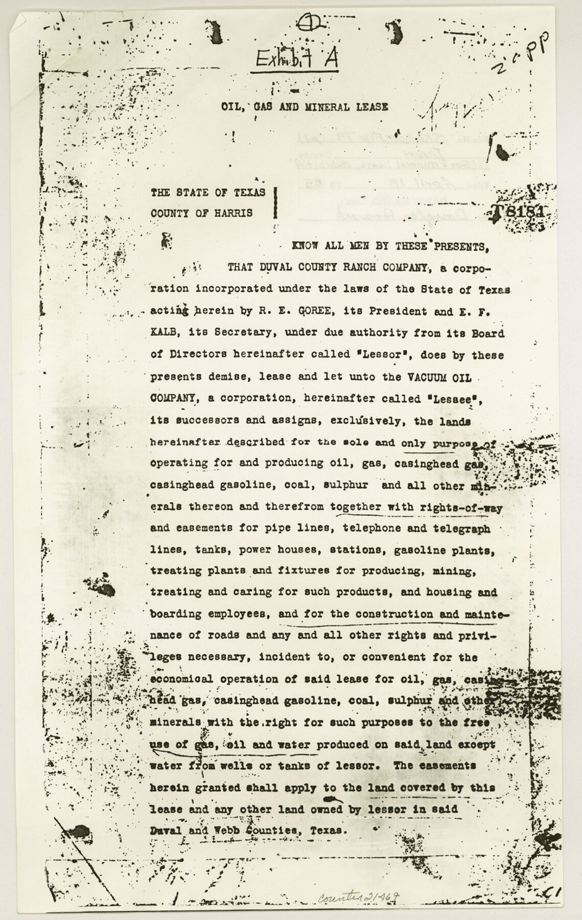
Duval County Sketch File 79
[Copy of Oil, Gas and Mineral Lease between Duval County Ranch Company and Vacuum Oil Company]
-
Map/Doc
21469
-
Collection
General Map Collection
-
Object Dates
1925/3/3 (Creation Date)
1985/4/19 (File Date)
-
Counties
Duval Webb
-
Subjects
Surveying Sketch File
-
Height x Width
14.3 x 9.1 inches
36.3 x 23.1 cm
-
Medium
photostat
Part of: General Map Collection
[Sketch for Mineral Application 21493 - Clay County]
![65625, [Sketch for Mineral Application 21493 - Clay County], General Map Collection](https://historictexasmaps.com/wmedia_w700/maps/65625-1.tif.jpg)
Print $40.00
- Digital $50.00
[Sketch for Mineral Application 21493 - Clay County]
Size 62.4 x 34.8 inches
Map/Doc 65625
Webb County Sketch File 50-1

Print $8.00
- Digital $50.00
Webb County Sketch File 50-1
1943
Size 14.5 x 8.9 inches
Map/Doc 39833
San Jacinto County Working Sketch 13

Print $20.00
- Digital $50.00
San Jacinto County Working Sketch 13
1935
Size 25.0 x 18.8 inches
Map/Doc 63726
Aransas County Aerial Photograph Index Sheet 4

Print $20.00
- Digital $50.00
Aransas County Aerial Photograph Index Sheet 4
1957
Size 23.6 x 16.1 inches
Map/Doc 83662
Wharton County Working Sketch 19

Print $20.00
- Digital $50.00
Wharton County Working Sketch 19
1940
Size 21.4 x 23.0 inches
Map/Doc 72483
Stephens County Working Sketch 25

Print $20.00
- Digital $50.00
Stephens County Working Sketch 25
1976
Size 37.4 x 32.3 inches
Map/Doc 63968
Eastland County Sketch File 13

Print $4.00
- Digital $50.00
Eastland County Sketch File 13
1887
Size 8.3 x 13.0 inches
Map/Doc 21593
Van Zandt County Working Sketch 4

Print $20.00
- Digital $50.00
Van Zandt County Working Sketch 4
1929
Size 16.3 x 26.8 inches
Map/Doc 72253
Louisiana and Texas Intracoastal Waterway, Sabine River Galveston Bay Section Survey

Print $20.00
- Digital $50.00
Louisiana and Texas Intracoastal Waterway, Sabine River Galveston Bay Section Survey
1927
Size 30.7 x 43.0 inches
Map/Doc 61838
Liberty County Sketch File 33

Print $4.00
- Digital $50.00
Liberty County Sketch File 33
Size 10.7 x 7.8 inches
Map/Doc 29967

Houston County Working Sketch 13

Print $20.00
- Digital $50.00
Houston County Working Sketch 13
1956
Size 39.3 x 39.6 inches
Map/Doc 66243
You may also like
Official Map of City of Lubbock

Print $20.00
- Digital $50.00
Official Map of City of Lubbock
1927
Size 29.3 x 22.7 inches
Map/Doc 92717
Montgomery County

Print $20.00
- Digital $50.00
Montgomery County
1901
Size 21.9 x 25.3 inches
Map/Doc 3898
Hamilton County Working Sketch Graphic Index

Print $20.00
- Digital $50.00
Hamilton County Working Sketch Graphic Index
1972
Size 34.3 x 39.8 inches
Map/Doc 76564
Ector County Working Sketch 17

Print $40.00
- Digital $50.00
Ector County Working Sketch 17
1956
Size 59.9 x 24.2 inches
Map/Doc 68860
Stonewall County Working Sketch 13

Print $20.00
- Digital $50.00
Stonewall County Working Sketch 13
1951
Size 31.9 x 33.7 inches
Map/Doc 62320
Hays County Working Sketch 12

Print $20.00
- Digital $50.00
Hays County Working Sketch 12
1950
Size 22.8 x 24.3 inches
Map/Doc 66086
Motley County Sketch File 6 (N)

Print $20.00
- Digital $50.00
Motley County Sketch File 6 (N)
1900
Size 14.0 x 8.6 inches
Map/Doc 32004
Young County Rolled Sketch 8

Print $20.00
- Digital $50.00
Young County Rolled Sketch 8
Size 40.5 x 25.8 inches
Map/Doc 8296
Trinity County, Texas

Print $20.00
- Digital $50.00
Trinity County, Texas
1882
Size 20.3 x 17.4 inches
Map/Doc 485

Brewster County Rolled Sketch 114

Print $20.00
- Digital $50.00
Brewster County Rolled Sketch 114
1964
Size 11.9 x 18.3 inches
Map/Doc 5290
Working Sketch in McMullen County

Print $3.00
- Digital $50.00
Working Sketch in McMullen County
1883
Size 11.7 x 12.1 inches
Map/Doc 576