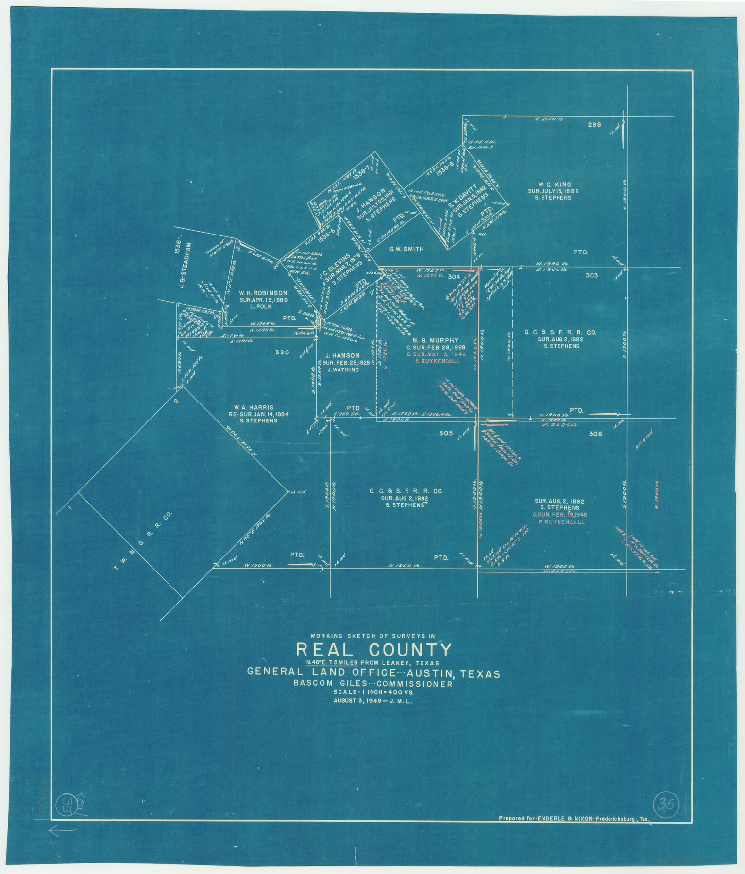
Real County Working Sketch 35
-
Map/Doc
71927
-
Collection
General Map Collection
-
Object Dates
8/3/1949 (Creation Date)
-
Counties
Real
-
Subjects
Surveying Working Sketch
-
Height x Width
27.7 x 23.6 inches
70.4 x 59.9 cm
-
Scale
1" = 400 varas
Part of: General Map Collection
Upper Galveston Bay, Houston Ship Channel, Dollar Pt. to Atkinson I.

Print $40.00
- Digital $50.00
Upper Galveston Bay, Houston Ship Channel, Dollar Pt. to Atkinson I.
1973
Size 49.8 x 36.8 inches
Map/Doc 69896
Hutchinson County Rolled Sketch 40

Print $20.00
- Digital $50.00
Hutchinson County Rolled Sketch 40
1981
Size 26.1 x 37.5 inches
Map/Doc 6298
Flight Mission No. BRA-7M, Frame 81, Jefferson County

Print $20.00
- Digital $50.00
Flight Mission No. BRA-7M, Frame 81, Jefferson County
1953
Size 16.0 x 15.8 inches
Map/Doc 85503
Sketch D No. 2 Showing the Progress of the Survey of Cape Fear and Vicinity in Sections No. IV & V

Digital $50.00
Sketch D No. 2 Showing the Progress of the Survey of Cape Fear and Vicinity in Sections No. IV & V
1852
Size 12.3 x 10.0 inches
Map/Doc 97209
Brazoria County NRC Article 33.136 Sketch 14

Print $36.00
- Digital $50.00
Brazoria County NRC Article 33.136 Sketch 14
2013
Size 24.0 x 36.0 inches
Map/Doc 95057
Coke County Working Sketch 6

Print $20.00
- Digital $50.00
Coke County Working Sketch 6
1914
Size 19.1 x 15.7 inches
Map/Doc 68043
Map of section no. 11 of a survey of Padre Island made for the Office of the Attorney General of the State of Texas

Print $40.00
- Digital $50.00
Map of section no. 11 of a survey of Padre Island made for the Office of the Attorney General of the State of Texas
1941
Size 60.1 x 40.4 inches
Map/Doc 2267
Chambers County NRC Article 33.136 Sketch 7

Print $28.00
- Digital $50.00
Chambers County NRC Article 33.136 Sketch 7
2011
Size 18.0 x 24.0 inches
Map/Doc 94753
Smith County Sketch File 9

Print $6.00
- Digital $50.00
Smith County Sketch File 9
1848
Size 16.2 x 10.4 inches
Map/Doc 36763
[Surveys by Brown in Austin's Little Colony along the Colorado River and Walnut Creek]
![196, [Surveys by Brown in Austin's Little Colony along the Colorado River and Walnut Creek], General Map Collection](https://historictexasmaps.com/wmedia_w700/maps/196.tif.jpg)
Print $20.00
- Digital $50.00
[Surveys by Brown in Austin's Little Colony along the Colorado River and Walnut Creek]
1832
Size 33.2 x 23.3 inches
Map/Doc 196
Liberty County Working Sketch 91a

Print $40.00
- Digital $50.00
Liberty County Working Sketch 91a
1919
Size 48.6 x 42.1 inches
Map/Doc 65457
Pecos County Rolled Sketch 26A

Print $40.00
- Digital $50.00
Pecos County Rolled Sketch 26A
1890
Size 19.0 x 55.5 inches
Map/Doc 75934
You may also like
San Patricio County Rolled Sketch 27A

Print $40.00
- Digital $50.00
San Patricio County Rolled Sketch 27A
Size 50.4 x 38.5 inches
Map/Doc 9891
Harris County Sketch File 23a

Print $13.00
- Digital $50.00
Harris County Sketch File 23a
1839
Size 9.7 x 6.0 inches
Map/Doc 25379
Scurry County Working Sketch 10

Print $20.00
- Digital $50.00
Scurry County Working Sketch 10
1990
Size 25.7 x 28.7 inches
Map/Doc 63839
Il Texas: La Ferrovia New York Texas-Messicana, La Colonizzazione Italiana della costa del Texas

Print $20.00
- Digital $50.00
Il Texas: La Ferrovia New York Texas-Messicana, La Colonizzazione Italiana della costa del Texas
1881
Size 17.6 x 22.0 inches
Map/Doc 97406
Brewster County Rolled Sketch 114

Print $20.00
- Digital $50.00
Brewster County Rolled Sketch 114
1964
Size 11.6 x 18.5 inches
Map/Doc 5275
General Highway Map, Dimmit County, Zavala County, Texas

Print $20.00
General Highway Map, Dimmit County, Zavala County, Texas
1961
Size 18.2 x 24.6 inches
Map/Doc 79444
Haskell County Rolled Sketch 11

Print $20.00
- Digital $50.00
Haskell County Rolled Sketch 11
1983
Size 23.0 x 28.0 inches
Map/Doc 6170
Midland County Rolled Sketch 6

Print $20.00
- Digital $50.00
Midland County Rolled Sketch 6
1951
Size 39.8 x 28.6 inches
Map/Doc 6764
University Lands Blocks 38 to 57, Crockett-Reagan-Irion-Schleicher-Counties

Print $40.00
- Digital $50.00
University Lands Blocks 38 to 57, Crockett-Reagan-Irion-Schleicher-Counties
Size 35.1 x 53.6 inches
Map/Doc 62945
Pecos County Rolled Sketch 127

Print $20.00
- Digital $50.00
Pecos County Rolled Sketch 127
Size 20.7 x 23.9 inches
Map/Doc 7267
Amherst Suburban Farms

Print $20.00
- Digital $50.00
Amherst Suburban Farms
Size 16.7 x 16.8 inches
Map/Doc 92265
Hutchinson County Rolled Sketch 44-18

Print $20.00
- Digital $50.00
Hutchinson County Rolled Sketch 44-18
2002
Size 24.0 x 36.0 inches
Map/Doc 77554