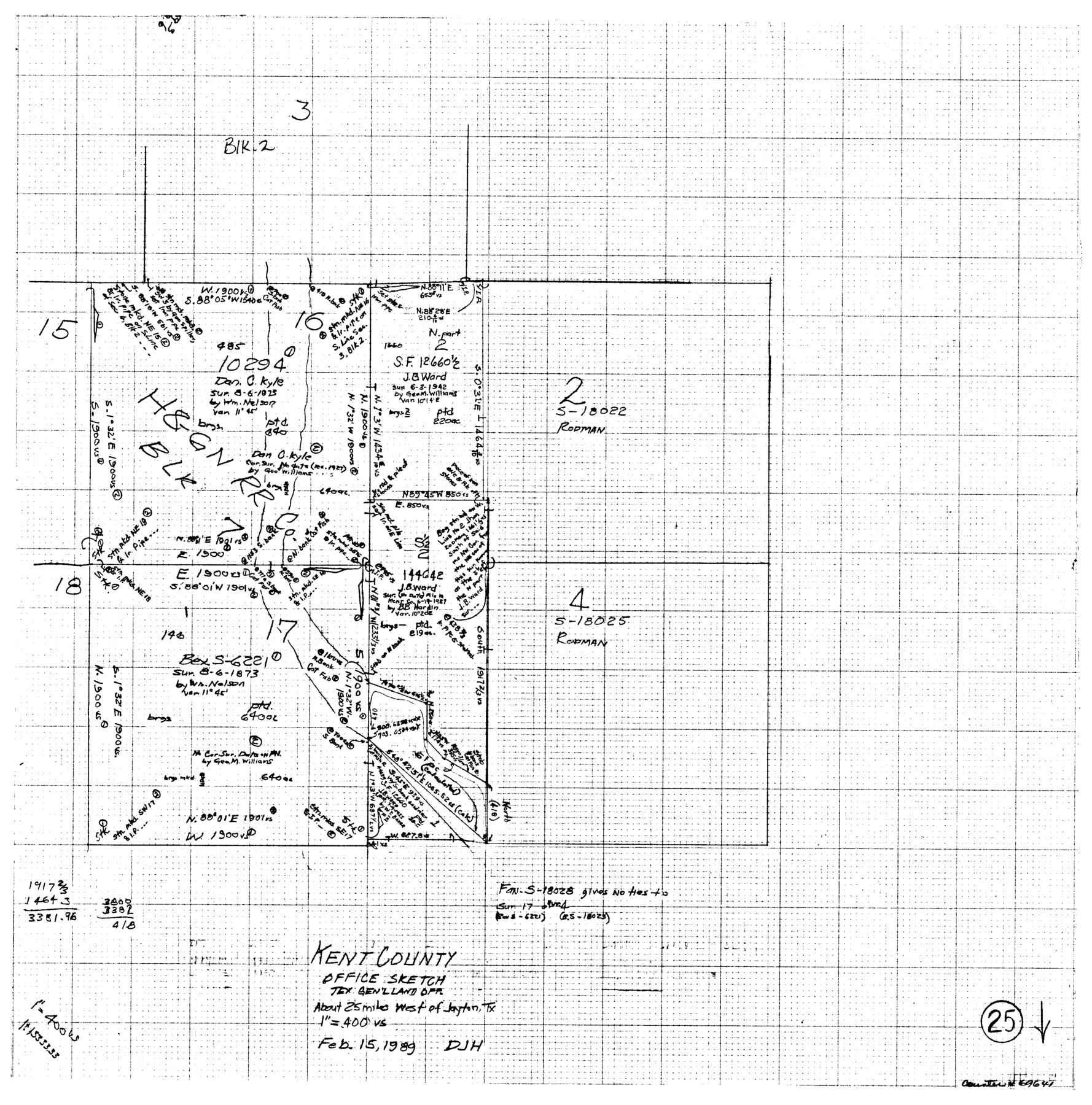
Kent County Working Sketch 25
-
Map/Doc
69641
-
Collection
General Map Collection
-
Object Dates
2/15/1989 (Creation Date)
-
People and Organizations
Douglas Howard (Draftsman)
-
Counties
Kent
-
Subjects
Surveying Working Sketch
-
Height x Width
18.8 x 18.5 inches
47.8 x 47.0 cm
-
Scale
1" = 400 varas
Part of: General Map Collection
Cooke County Sketch File 34

Print $44.00
- Digital $50.00
Cooke County Sketch File 34
Size 11.8 x 8.2 inches
Map/Doc 19298
[Surveys along the San Fernando and Santa Gertrudis, San Patricio District]
![290, [Surveys along the San Fernando and Santa Gertrudis, San Patricio District], General Map Collection](https://historictexasmaps.com/wmedia_w700/maps/290.tif.jpg)
Print $20.00
- Digital $50.00
[Surveys along the San Fernando and Santa Gertrudis, San Patricio District]
1847
Size 13.2 x 16.4 inches
Map/Doc 290
Dickens County Sketch File G

Print $8.00
- Digital $50.00
Dickens County Sketch File G
Size 12.0 x 8.7 inches
Map/Doc 20854
Flight Mission No. CLL-1N, Frame 113, Willacy County

Print $20.00
- Digital $50.00
Flight Mission No. CLL-1N, Frame 113, Willacy County
1954
Size 18.3 x 22.0 inches
Map/Doc 87047
Pecos County Sketch File 104

Print $36.00
- Digital $50.00
Pecos County Sketch File 104
1966
Size 11.3 x 8.7 inches
Map/Doc 34020
Webb County Rolled Sketch 61

Print $20.00
- Digital $50.00
Webb County Rolled Sketch 61
1947
Size 38.6 x 36.5 inches
Map/Doc 10128
Map of the Territory of the United States from the Mississippi to the Pacific Ocean ordered by the Hon. Jeff'n Davis, Secretary of War to accompany the reports of the explorations for a railroad route

Print $40.00
- Digital $50.00
Map of the Territory of the United States from the Mississippi to the Pacific Ocean ordered by the Hon. Jeff'n Davis, Secretary of War to accompany the reports of the explorations for a railroad route
Size 48.6 x 50.7 inches
Map/Doc 94276
Galveston Entrance, Texas From a Trigonometrical Survey Under the direction of A.D. Bache Superintendent of the Survey of the Coast of the United States

Print $20.00
- Digital $50.00
Galveston Entrance, Texas From a Trigonometrical Survey Under the direction of A.D. Bache Superintendent of the Survey of the Coast of the United States
1853
Size 15.9 x 19.3 inches
Map/Doc 93998
Flight Mission No. DAG-21K, Frame 85, Matagorda County

Print $20.00
- Digital $50.00
Flight Mission No. DAG-21K, Frame 85, Matagorda County
1952
Size 18.5 x 22.3 inches
Map/Doc 86414
Flight Mission No. CRE-2R, Frame 89, Jackson County

Print $20.00
- Digital $50.00
Flight Mission No. CRE-2R, Frame 89, Jackson County
1956
Size 18.6 x 22.2 inches
Map/Doc 85361
Jefferson County Rolled Sketch 8A

Print $20.00
- Digital $50.00
Jefferson County Rolled Sketch 8A
1928
Size 35.6 x 46.3 inches
Map/Doc 76030
Map of the City of Galveston Situated on the East end of Galveston Island

Print $20.00
- Digital $50.00
Map of the City of Galveston Situated on the East end of Galveston Island
1838
Size 25.8 x 43.0 inches
Map/Doc 73628
You may also like
Midland County Working Sketch 16

Print $40.00
- Digital $50.00
Midland County Working Sketch 16
1953
Size 61.7 x 32.6 inches
Map/Doc 70996
San Jacinto County Working Sketch 28

Print $20.00
- Digital $50.00
San Jacinto County Working Sketch 28
1945
Size 32.6 x 26.5 inches
Map/Doc 63741

[Blocks B5, 46, and 47]
![91189, [Blocks B5, 46, and 47], Twichell Survey Records](https://historictexasmaps.com/wmedia_w700/maps/91189-1.tif.jpg)
Print $20.00
- Digital $50.00
[Blocks B5, 46, and 47]
1886
Size 23.1 x 16.8 inches
Map/Doc 91189
Lubbock County

Print $20.00
- Digital $50.00
Lubbock County
1879
Size 23.8 x 21.7 inches
Map/Doc 3829
Hutchinson County Working Sketch 13

Print $20.00
- Digital $50.00
Hutchinson County Working Sketch 13
1926
Size 22.6 x 31.5 inches
Map/Doc 66371
Flight Mission No. DAG-19K, Frame 59, Matagorda County

Print $20.00
- Digital $50.00
Flight Mission No. DAG-19K, Frame 59, Matagorda County
1952
Size 18.6 x 22.2 inches
Map/Doc 86386
Flight Mission No. CRC-2R, Frame 195, Chambers County

Print $20.00
- Digital $50.00
Flight Mission No. CRC-2R, Frame 195, Chambers County
1956
Size 18.6 x 22.3 inches
Map/Doc 84773
Bee County Working Sketch 1

Print $20.00
- Digital $50.00
Bee County Working Sketch 1
Size 23.2 x 40.4 inches
Map/Doc 67251
Connected Map of Austin's Colony

Print $20.00
- Digital $50.00
Connected Map of Austin's Colony
1892
Size 47.5 x 43.0 inches
Map/Doc 76074
Controlled Mosaic by Jack Amman Photogrammetric Engineers, Inc - Sheet 11

Print $20.00
- Digital $50.00
Controlled Mosaic by Jack Amman Photogrammetric Engineers, Inc - Sheet 11
1954
Size 20.0 x 24.0 inches
Map/Doc 83455
Lipscomb County Sketch File 4

Print $56.00
- Digital $50.00
Lipscomb County Sketch File 4
1910
Size 11.2 x 8.7 inches
Map/Doc 30233