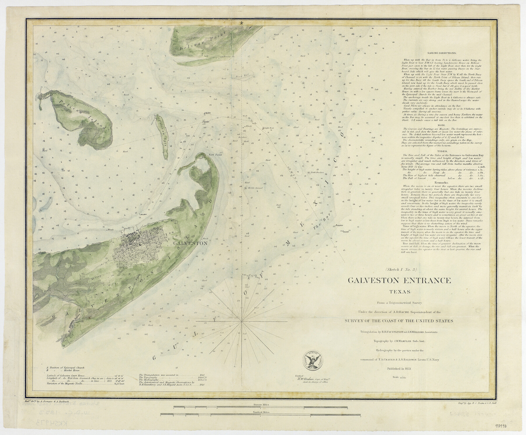
Galveston Entrance, Texas From a Trigonometrical Survey Under the direction of A.D. Bache Superintendent of the Survey of the Coast of the United States
-
Map/Doc
93998
-
Collection
General Map Collection
-
Object Dates
1853 (Creation Date)
-
People and Organizations
U.S. Coast Survey Office (Publisher)
-
Subjects
Gulf of Mexico Nautical Charts
-
Height x Width
15.9 x 19.3 inches
40.4 x 49.0 cm
-
Medium
paper, etching/engraving/lithograph
-
Comments
Conservation funded by the Summerlee Foundation.
Part of: General Map Collection
Callahan County Working Sketch 15

Print $20.00
- Digital $50.00
Callahan County Working Sketch 15
2010
Size 22.6 x 27.3 inches
Map/Doc 89295
Grayson County

Print $20.00
- Digital $50.00
Grayson County
1935
Size 43.3 x 39.9 inches
Map/Doc 77294
Colorado County Working Sketch 2

Print $20.00
- Digital $50.00
Colorado County Working Sketch 2
1904
Size 28.8 x 30.1 inches
Map/Doc 68102
Fannin County Boundary File 1

Print $14.00
- Digital $50.00
Fannin County Boundary File 1
Size 13.2 x 8.6 inches
Map/Doc 53272
Edwards County Boundary File 27 1/2

Print $58.00
- Digital $50.00
Edwards County Boundary File 27 1/2
Size 9.1 x 4.4 inches
Map/Doc 52911
The Texas and Pacific Ry. Co., Station Map, Colorado, Texas

Print $20.00
- Digital $50.00
The Texas and Pacific Ry. Co., Station Map, Colorado, Texas
Size 11.7 x 18.8 inches
Map/Doc 64677
Hamilton County Working Sketch 15

Print $40.00
- Digital $50.00
Hamilton County Working Sketch 15
1949
Size 54.5 x 37.6 inches
Map/Doc 63353
Jefferson County Working Sketch 27

Print $40.00
- Digital $50.00
Jefferson County Working Sketch 27
1977
Size 43.2 x 49.4 inches
Map/Doc 66570
Hall County Boundary File 2

Print $12.00
- Digital $50.00
Hall County Boundary File 2
Size 11.1 x 8.6 inches
Map/Doc 54177
Harrison County Working Sketch 9

Print $20.00
- Digital $50.00
Harrison County Working Sketch 9
1956
Size 23.6 x 24.9 inches
Map/Doc 66029
[Sketch for Mineral Application 26501 - Sabine River, T. A. Oldhausen]
![2833, [Sketch for Mineral Application 26501 - Sabine River, T. A. Oldhausen], General Map Collection](https://historictexasmaps.com/wmedia_w700/maps/2833.tif.jpg)
Print $20.00
- Digital $50.00
[Sketch for Mineral Application 26501 - Sabine River, T. A. Oldhausen]
1931
Size 24.4 x 36.3 inches
Map/Doc 2833
Bexar County Working Sketch 10

Print $20.00
- Digital $50.00
Bexar County Working Sketch 10
1959
Size 22.6 x 34.5 inches
Map/Doc 67326
You may also like
Crockett County Working Sketch 49

Print $20.00
- Digital $50.00
Crockett County Working Sketch 49
1938
Size 46.7 x 43.9 inches
Map/Doc 68382
[FT. W. & R. G. Ry. Right of Way Map, Winchell to Brady, McCulloch County, Texas]
![61415, [FT. W. & R. G. Ry. Right of Way Map, Winchell to Brady, McCulloch County, Texas], General Map Collection](https://historictexasmaps.com/wmedia_w700/maps/61415.tif.jpg)
Print $40.00
- Digital $50.00
[FT. W. & R. G. Ry. Right of Way Map, Winchell to Brady, McCulloch County, Texas]
1918
Size 38.2 x 122.0 inches
Map/Doc 61415
Wise County Sketch File 11

Print $4.00
- Digital $50.00
Wise County Sketch File 11
1860
Size 12.8 x 8.0 inches
Map/Doc 40544
Amistad International Reservoir on Rio Grande 111

Print $20.00
- Digital $50.00
Amistad International Reservoir on Rio Grande 111
1950
Size 28.5 x 41.0 inches
Map/Doc 75542
Brewster County Boundary File 1b

Print $32.00
- Digital $50.00
Brewster County Boundary File 1b
Size 9.2 x 11.3 inches
Map/Doc 50740
Gillespie County

Print $20.00
- Digital $50.00
Gillespie County
1945
Size 36.7 x 45.6 inches
Map/Doc 77289
Martin County Working Sketch 18

Print $20.00
- Digital $50.00
Martin County Working Sketch 18
1982
Size 39.9 x 37.4 inches
Map/Doc 70836
[Sketch for Mineral Application 13440]
![65674, [Sketch for Mineral Application 13440], General Map Collection](https://historictexasmaps.com/wmedia_w700/maps/65674.tif.jpg)
Print $40.00
- Digital $50.00
[Sketch for Mineral Application 13440]
Size 65.8 x 42.9 inches
Map/Doc 65674
Map of Texas with population and location of principal towns and cities according to latest reliable statistics

Print $20.00
- Digital $50.00
Map of Texas with population and location of principal towns and cities according to latest reliable statistics
1909
Size 18.3 x 20.2 inches
Map/Doc 95874
Platt [sic] of Late Surveys on Carancahua, Jackson County
![78360, Platt [sic] of Late Surveys on Carancahua, Jackson County, General Map Collection](https://historictexasmaps.com/wmedia_w700/maps/78360.tif.jpg)
Print $2.00
- Digital $50.00
Platt [sic] of Late Surveys on Carancahua, Jackson County
Size 10.9 x 8.0 inches
Map/Doc 78360
Moore County Sketch File 3

Print $20.00
- Digital $50.00
Moore County Sketch File 3
Size 17.2 x 19.3 inches
Map/Doc 42126
Post Route Map of Texas (Inset 1: Dallas-Fort Worth Area; Inset 2: Texas Panhandle)

Print $40.00
- Digital $50.00
Post Route Map of Texas (Inset 1: Dallas-Fort Worth Area; Inset 2: Texas Panhandle)
1939
Size 56.9 x 39.3 inches
Map/Doc 93668