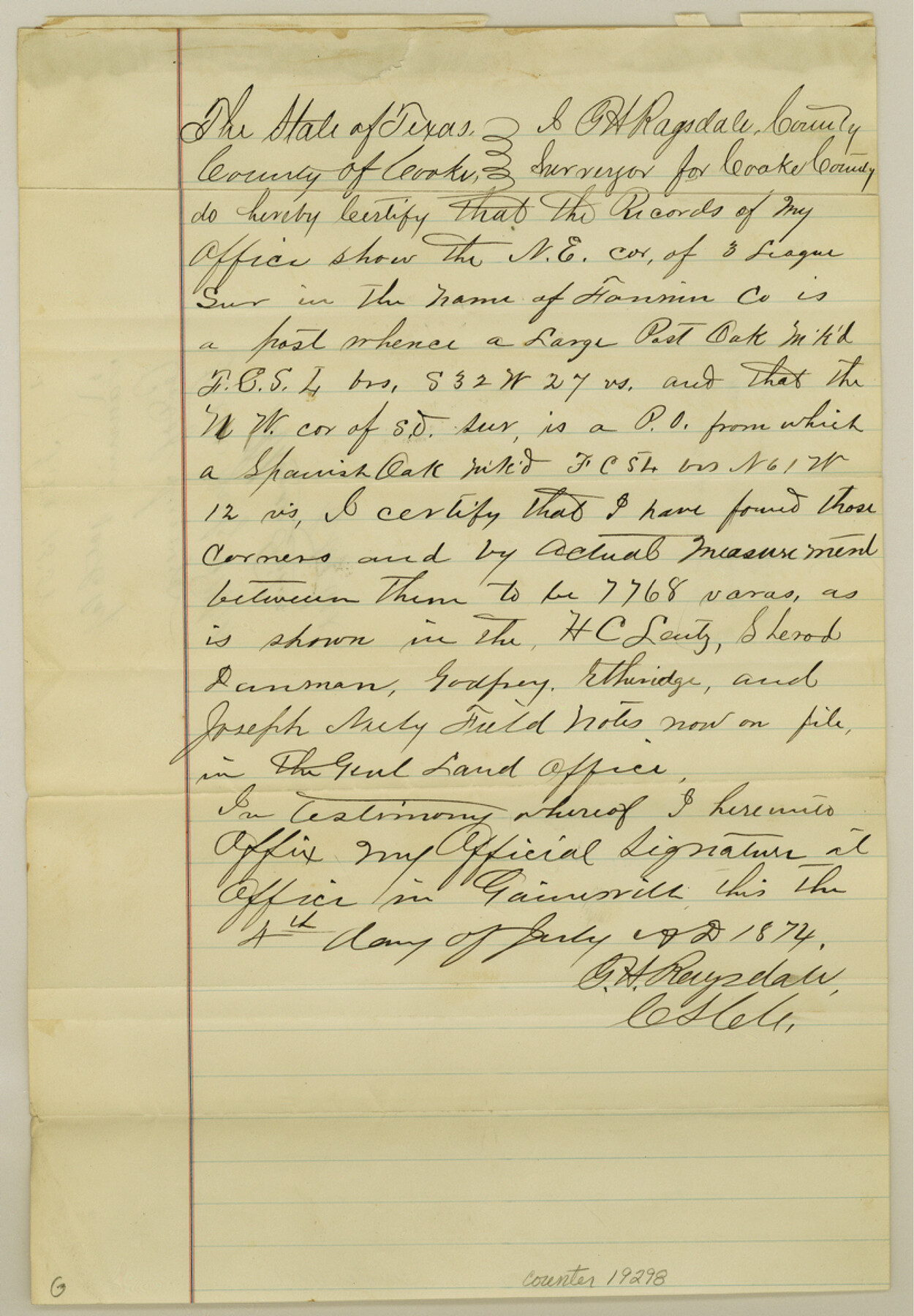
Cooke County Sketch File 34
[Sketch of surveys in the northeast part of county]
-
Map/Doc
19298
-
Collection
General Map Collection
-
People and Organizations
Rhoads Fisher (GLO Clerk)
G.H. Ragsdale (Surveyor/Engineer)
-
Counties
Cooke Fannin
-
Subjects
Surveying Sketch File
-
Height x Width
11.8 x 8.2 inches
30.0 x 20.8 cm
-
Medium
paper, manuscript
-
Features
Red River
Hickory Creek
East Fork of Hickory Creek
Part of: General Map Collection

Map of Washington District

Print $20.00
- Digital $50.00
Map of Washington District
1847
Size 17.6 x 26.8 inches
Map/Doc 4125
Knox County Boundary File 1a

Print $16.00
- Digital $50.00
Knox County Boundary File 1a
Size 9.7 x 13.8 inches
Map/Doc 65010
Collin County Rolled Sketch 2

Print $20.00
- Digital $50.00
Collin County Rolled Sketch 2
Size 33.3 x 26.1 inches
Map/Doc 8636
Hudspeth County Sketch File 17

Print $11.00
- Digital $50.00
Hudspeth County Sketch File 17
1929
Size 9.3 x 14.6 inches
Map/Doc 26954
Bexar County State Real Property Sketch 5

Print $40.00
- Digital $50.00
Bexar County State Real Property Sketch 5
2019
Size 48.0 x 35.8 inches
Map/Doc 95710
Crane County Sketch File 6

Print $20.00
- Digital $50.00
Crane County Sketch File 6
Size 18.7 x 22.8 inches
Map/Doc 11207
Hudspeth County Working Sketch 65

Print $40.00
- Digital $50.00
Hudspeth County Working Sketch 65
2007
Size 32.9 x 61.6 inches
Map/Doc 88732
Blanco County Sketch File 11

Print $4.00
- Digital $50.00
Blanco County Sketch File 11
Size 4.0 x 7.6 inches
Map/Doc 14590
Harbor of Brazos Santiago, Texas

Print $20.00
- Digital $50.00
Harbor of Brazos Santiago, Texas
1887
Size 27.2 x 18.4 inches
Map/Doc 72996
Rains County Working Sketch 1

Print $20.00
- Digital $50.00
Rains County Working Sketch 1
Size 12.3 x 17.3 inches
Map/Doc 71827
Brown County Sketch File 30

Print $27.00
- Digital $50.00
Brown County Sketch File 30
1924
Size 12.7 x 11.0 inches
Map/Doc 16631
You may also like
Cottle County Sketch File 3

Print $4.00
- Digital $50.00
Cottle County Sketch File 3
Size 10.0 x 8.4 inches
Map/Doc 19457
Presidio County Working Sketch 132

Print $20.00
- Digital $50.00
Presidio County Working Sketch 132
1989
Size 36.7 x 29.4 inches
Map/Doc 71810
Flight Mission No. DAG-24K, Frame 151, Matagorda County

Print $20.00
- Digital $50.00
Flight Mission No. DAG-24K, Frame 151, Matagorda County
1953
Size 18.5 x 22.1 inches
Map/Doc 86565
La Salle County Sketch File 38

Print $40.00
- Digital $50.00
La Salle County Sketch File 38
Size 13.7 x 14.5 inches
Map/Doc 29590
Harrison County Rolled Sketch 5

Print $20.00
- Digital $50.00
Harrison County Rolled Sketch 5
1949
Size 33.7 x 19.3 inches
Map/Doc 6467
Red River County Sketch File 10

Print $15.00
- Digital $50.00
Red River County Sketch File 10
1863
Size 9.1 x 7.4 inches
Map/Doc 35121
Cherokee County Boundary File 1

Print $34.00
- Digital $50.00
Cherokee County Boundary File 1
Size 14.2 x 8.7 inches
Map/Doc 51272
Bell County Working Sketch 9

Print $20.00
- Digital $50.00
Bell County Working Sketch 9
1954
Size 32.3 x 27.9 inches
Map/Doc 67349
Midland County Working Sketch 14

Print $40.00
- Digital $50.00
Midland County Working Sketch 14
1953
Size 65.0 x 31.0 inches
Map/Doc 70994
Map of Mexico, including Yucatan & Upper California, exhibiting the chief cities and towns, the principal travelling routes &c.

Print $20.00
- Digital $50.00
Map of Mexico, including Yucatan & Upper California, exhibiting the chief cities and towns, the principal travelling routes &c.
1846
Size 18.3 x 26.1 inches
Map/Doc 93871
Freestone County Working Sketch 12

Print $40.00
- Digital $50.00
Freestone County Working Sketch 12
1980
Size 54.5 x 38.6 inches
Map/Doc 69254
Map of Jack County

Print $20.00
- Digital $50.00
Map of Jack County
Size 18.4 x 15.9 inches
Map/Doc 3702