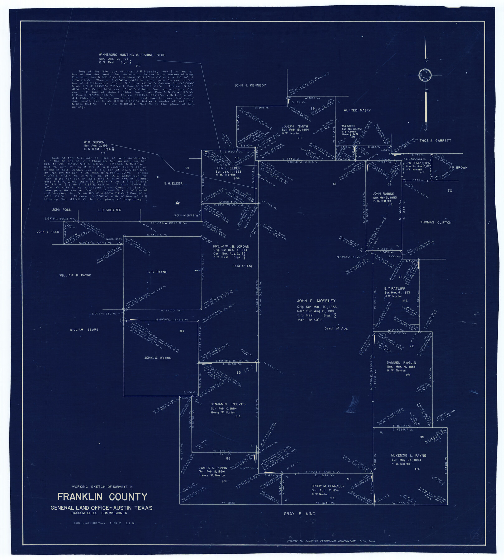
Franklin County Working Sketch 2
-
Map/Doc
69240
-
Collection
General Map Collection
-
Object Dates
4/23/1953 (Creation Date)
-
Counties
Franklin
-
Subjects
Surveying Working Sketch
-
Height x Width
33.3 x 29.9 inches
84.6 x 76.0 cm
-
Scale
1" = 300 varas
Part of: General Map Collection
Crane County Rolled Sketch 28

Print $40.00
- Digital $50.00
Crane County Rolled Sketch 28
2020
Size 35.7 x 51.2 inches
Map/Doc 96434
Portion of States Submerged Area in Matagorda Bay

Print $20.00
- Digital $50.00
Portion of States Submerged Area in Matagorda Bay
1919
Size 16.8 x 17.2 inches
Map/Doc 2949
San Saba County

Print $20.00
- Digital $50.00
San Saba County
1987
Size 43.5 x 47.3 inches
Map/Doc 95635

Wharton County Boundary File 1

Print $24.00
- Digital $50.00
Wharton County Boundary File 1
Size 14.2 x 8.9 inches
Map/Doc 59839
Hardin County Working Sketch 26

Print $20.00
- Digital $50.00
Hardin County Working Sketch 26
1954
Size 19.5 x 23.8 inches
Map/Doc 63424
Hays County Rolled Sketch 19

Print $20.00
- Digital $50.00
Hays County Rolled Sketch 19
1887
Size 26.7 x 22.3 inches
Map/Doc 6175
Van Zandt County Sketch File 17 and 17a

Print $6.00
- Digital $50.00
Van Zandt County Sketch File 17 and 17a
1858
Size 14.2 x 8.1 inches
Map/Doc 39417
Harris County Sketch File 102

Print $163.00
- Digital $50.00
Harris County Sketch File 102
1985
Size 11.4 x 8.9 inches
Map/Doc 25915
Jack County Working Sketch 22

Print $20.00
- Digital $50.00
Jack County Working Sketch 22
1995
Size 23.9 x 36.7 inches
Map/Doc 66448
Reagan County Sketch File 24

Print $6.00
- Digital $50.00
Reagan County Sketch File 24
1940
Size 11.4 x 8.7 inches
Map/Doc 35018
Polk County Sketch File 39

Print $24.00
- Digital $50.00
Polk County Sketch File 39
Size 8.3 x 13.3 inches
Map/Doc 34278
You may also like
Jim Wells County Boundary File 3

Print $10.00
- Digital $50.00
Jim Wells County Boundary File 3
Size 9.3 x 6.0 inches
Map/Doc 55546
Jasper County Sketch File 27

Print $22.00
- Digital $50.00
Jasper County Sketch File 27
Size 11.4 x 8.8 inches
Map/Doc 27842
La Salle County Sketch File 43

Print $20.00
- Digital $50.00
La Salle County Sketch File 43
1937
Size 18.7 x 28.4 inches
Map/Doc 11988
19th Congressional District of Texas

Print $20.00
- Digital $50.00
19th Congressional District of Texas
Size 33.1 x 28.9 inches
Map/Doc 92610
Mitchell County Working Sketch 7

Print $20.00
- Digital $50.00
Mitchell County Working Sketch 7
1963
Size 38.6 x 22.6 inches
Map/Doc 71064
The Republic County of Harrison. January 8, 1844

Print $20.00
The Republic County of Harrison. January 8, 1844
2020
Size 18.6 x 21.7 inches
Map/Doc 96175
Fisher County Sketch File 17

Print $6.00
- Digital $50.00
Fisher County Sketch File 17
Size 11.0 x 12.5 inches
Map/Doc 22587
Hood County Sketch File 9

Print $26.00
- Digital $50.00
Hood County Sketch File 9
1859
Size 9.6 x 4.5 inches
Map/Doc 26586
[H. & G. N. RR. Co. Block 1]
![90892, [H. & G. N. RR. Co. Block 1], Twichell Survey Records](https://historictexasmaps.com/wmedia_w700/maps/90892-1.tif.jpg)
Print $20.00
- Digital $50.00
[H. & G. N. RR. Co. Block 1]
1902
Size 14.9 x 15.8 inches
Map/Doc 90892
Starr County Rolled Sketch 41

Print $6.00
- Digital $50.00
Starr County Rolled Sketch 41
1971
Size 10.8 x 15.8 inches
Map/Doc 49030
Trinity River, Kaufman Sheet/Kings Creek

Print $6.00
- Digital $50.00
Trinity River, Kaufman Sheet/Kings Creek
1930
Size 32.6 x 27.0 inches
Map/Doc 65228
Map of the Capitol Land Reservation

Print $40.00
- Digital $50.00
Map of the Capitol Land Reservation
Size 26.3 x 49.5 inches
Map/Doc 92042