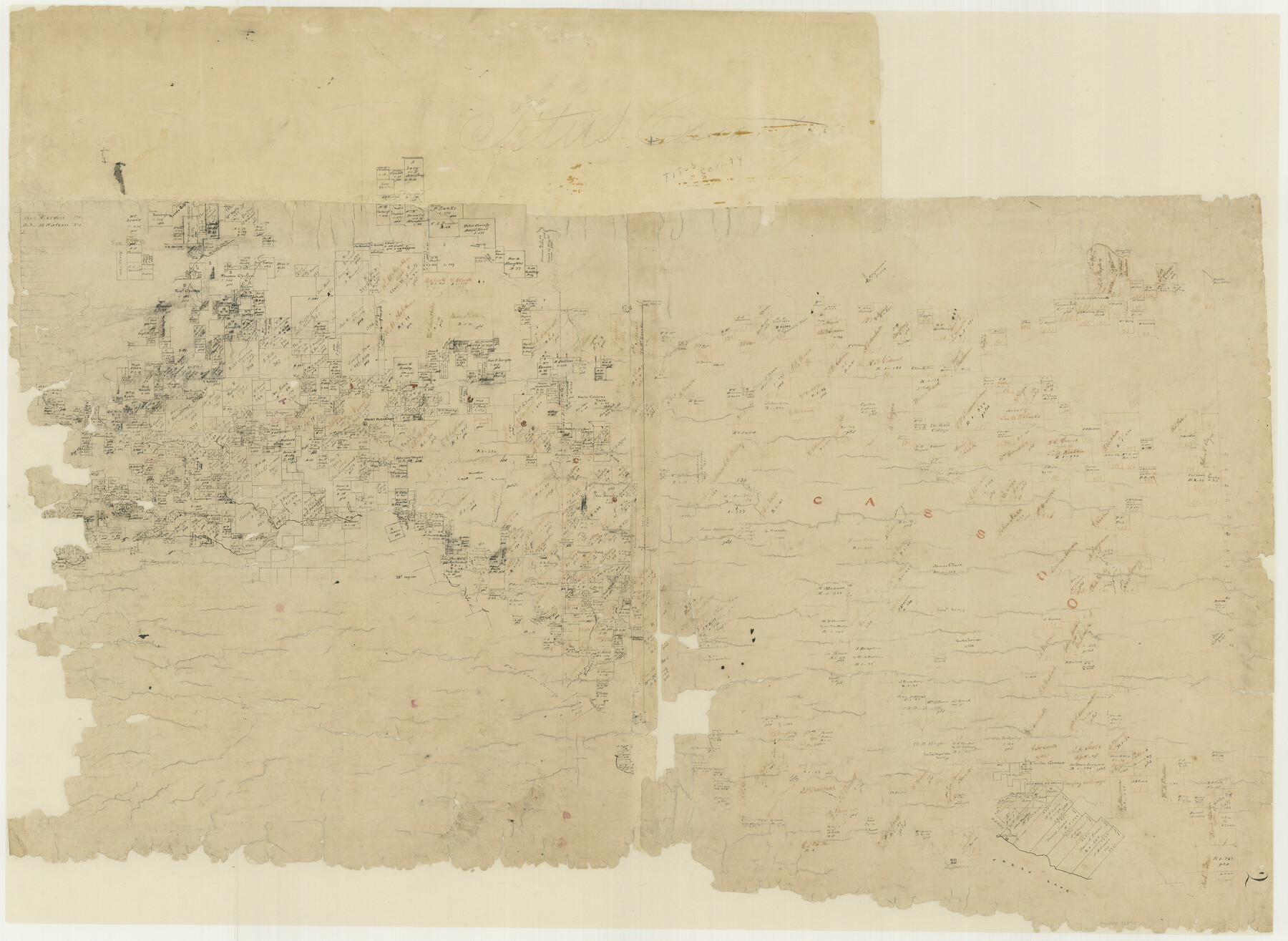
Titus County
-
Map/Doc
16897
-
Collection
General Map Collection
-
Object Dates
1858 (Creation Date)
-
Counties
Titus Cass Morris Marion
-
Subjects
County
-
Height x Width
27.9 x 38.1 inches
70.9 x 96.8 cm
-
Comments
The date of 1858 was marked on the back of map.
Conservation funded in 2002 with donations from the Northeast Texas Chapter 23 of the Texas Society of Professional Surveyors and Knox and Associates. -
Features
Gims Bayou
Swanano Creek
Bear Creek
Indian Creek
Dangerfield
Choctaw Creek
Bruton's Creek
Old Choctaw Village
Jim's Bayou
Pankersly Creek
Smithland
Jefferson
Deer Creek
Smith Creek
Cedar Prairie
Caddo Trace
Bankers Creek
Ferry Lake
Ripley's Creek
Stone Coal Bluff
Epperson's Ferry
White Oak Creek
Mill Creek
Stephenson Ferry
Trammell's Trace
Brown Creek
Horse Creek
Trent's Crossing
Boggy Creek
Harts Creek
Mount Pleasant
Blundel's Creek
Big Creek
Panther Creek
Jake's Creek
Part of: General Map Collection
Newton County Rolled Sketch 25

Print $20.00
- Digital $50.00
Newton County Rolled Sketch 25
1893
Size 17.1 x 21.4 inches
Map/Doc 6854
Webb County Sketch File 67

Print $20.00
- Digital $50.00
Webb County Sketch File 67
1953
Size 32.8 x 46.1 inches
Map/Doc 10430
San Patricio County Working Sketch 24
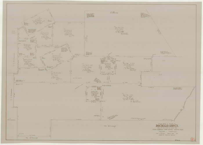
Print $20.00
- Digital $50.00
San Patricio County Working Sketch 24
1988
Size 30.9 x 43.0 inches
Map/Doc 63786
[Pecos and Northern Texas Ry., Bailey Co., from Parmer Co. line through Lariat and Muleshoe to Lamb Co. line]
![64636, [Pecos and Northern Texas Ry., Bailey Co., from Parmer Co. line through Lariat and Muleshoe to Lamb Co. line], General Map Collection](https://historictexasmaps.com/wmedia_w700/maps/64636.tif.jpg)
Print $40.00
- Digital $50.00
[Pecos and Northern Texas Ry., Bailey Co., from Parmer Co. line through Lariat and Muleshoe to Lamb Co. line]
1912
Size 20.3 x 121.9 inches
Map/Doc 64636
Map of Refugio County

Print $20.00
- Digital $50.00
Map of Refugio County
1885
Size 19.8 x 25.9 inches
Map/Doc 3986
Leon County Working Sketch 31

Print $20.00
- Digital $50.00
Leon County Working Sketch 31
1974
Size 24.4 x 18.6 inches
Map/Doc 70430
Flight Mission No. CRE-1R, Frame 132, Jackson County

Print $20.00
- Digital $50.00
Flight Mission No. CRE-1R, Frame 132, Jackson County
1956
Size 16.2 x 16.0 inches
Map/Doc 85340
Clay County Sketch File 34

Print $4.00
- Digital $50.00
Clay County Sketch File 34
Size 9.6 x 7.4 inches
Map/Doc 18461
Topographical Map of the Rio Grande, Sheet No. 5

Print $20.00
- Digital $50.00
Topographical Map of the Rio Grande, Sheet No. 5
1912
Map/Doc 89529
Map of Galveston Bay from Lawrence Cove to Stevenson's Station

Print $20.00
- Digital $50.00
Map of Galveston Bay from Lawrence Cove to Stevenson's Station
1851
Size 41.5 x 30.0 inches
Map/Doc 69922
Township 4 North Range 13 West, North Western District, Louisiana

Print $20.00
- Digital $50.00
Township 4 North Range 13 West, North Western District, Louisiana
1884
Size 19.6 x 24.6 inches
Map/Doc 65866
Caddo Lake and Subdivision

Print $20.00
- Digital $50.00
Caddo Lake and Subdivision
1918
Size 35.0 x 29.8 inches
Map/Doc 93283
You may also like
[C. C. Slaughter Block 1, T. T. RR. Co. Block 2]
![90622, [C. C. Slaughter Block 1, T. T. RR. Co. Block 2], Twichell Survey Records](https://historictexasmaps.com/wmedia_w700/maps/90622-1.tif.jpg)
Print $3.00
- Digital $50.00
[C. C. Slaughter Block 1, T. T. RR. Co. Block 2]
Size 10.5 x 10.8 inches
Map/Doc 90622
Live Oak County Working Sketch 29

Print $20.00
- Digital $50.00
Live Oak County Working Sketch 29
1983
Size 33.7 x 42.8 inches
Map/Doc 70614
Llano County Sketch File 9

Print $42.00
- Digital $50.00
Llano County Sketch File 9
Size 8.6 x 13.1 inches
Map/Doc 30369
Montague County

Print $20.00
- Digital $50.00
Montague County
1924
Size 47.9 x 34.7 inches
Map/Doc 95593
Baylor County Boundary File 10

Print $38.00
- Digital $50.00
Baylor County Boundary File 10
Size 9.4 x 7.7 inches
Map/Doc 50409
Flight Mission No. CUG-1P, Frame 158, Kleberg County

Print $20.00
- Digital $50.00
Flight Mission No. CUG-1P, Frame 158, Kleberg County
1956
Size 18.5 x 22.3 inches
Map/Doc 86165
Erath County Working Sketch 14

Print $20.00
- Digital $50.00
Erath County Working Sketch 14
1959
Size 24.7 x 21.9 inches
Map/Doc 69095
Old Miscellaneous File 24

Print $6.00
- Digital $50.00
Old Miscellaneous File 24
1919
Size 14.4 x 8.7 inches
Map/Doc 75629
Uvalde County

Print $20.00
- Digital $50.00
Uvalde County
1976
Size 43.0 x 46.3 inches
Map/Doc 95660
Live Oak County Sketch File 25

Print $16.00
- Digital $50.00
Live Oak County Sketch File 25
1919
Size 9.0 x 8.5 inches
Map/Doc 30301
Travis County Sketch File 36

Print $4.00
- Digital $50.00
Travis County Sketch File 36
1912
Size 8.4 x 9.9 inches
Map/Doc 38355
Schleicher County Sketch File 35

Print $20.00
- Digital $50.00
Schleicher County Sketch File 35
1951
Size 13.8 x 19.4 inches
Map/Doc 12308