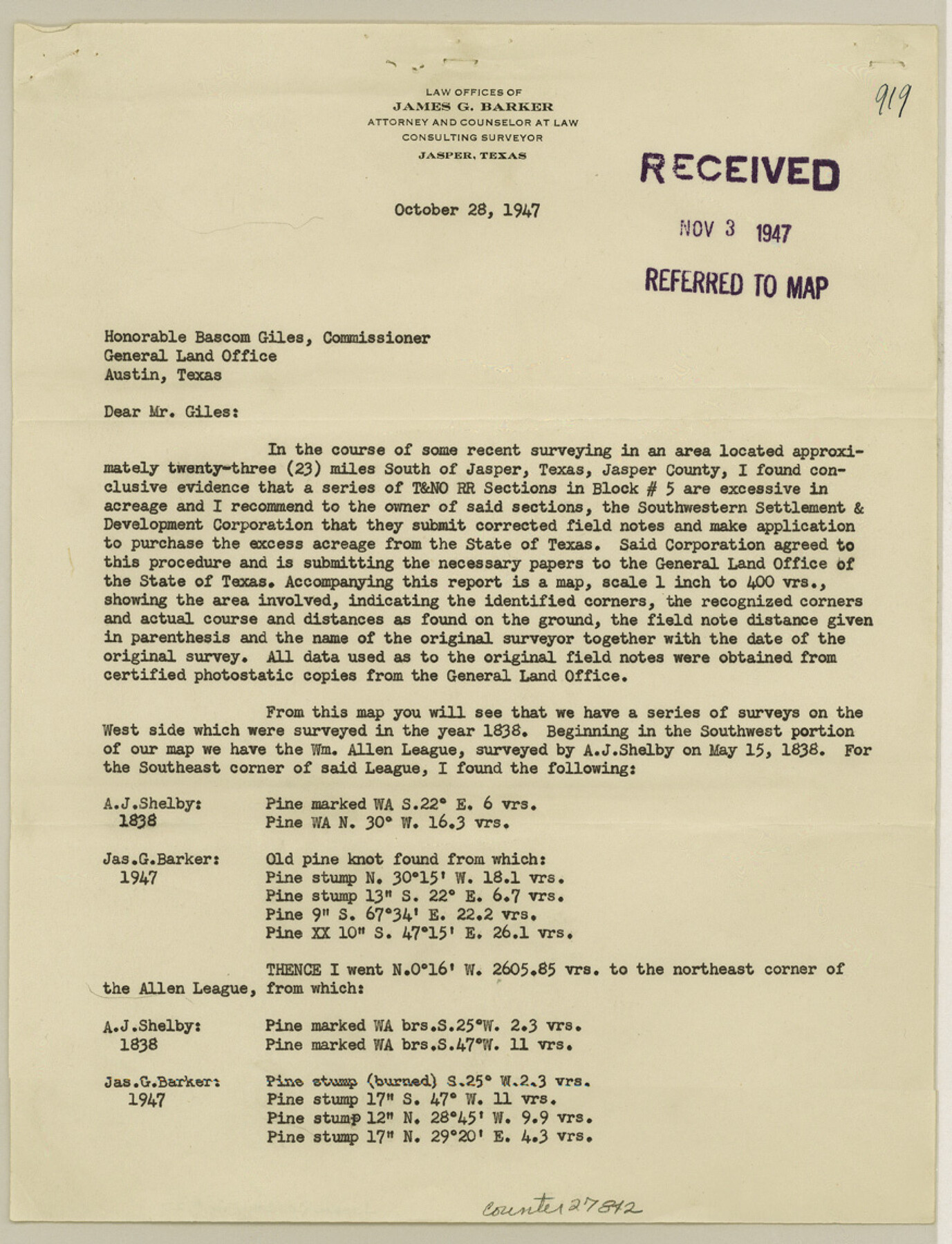
Jasper County Sketch File 27
[Report of resurvey of T. & N. O. R.R. Co. Block 5]
-
Map/Doc
27842
-
Collection
General Map Collection
-
Object Dates
11/3/1947 (File Date)
10/28/1947 (Correspondence Date)
5/15/1838 (Survey Date)
1947 (Survey Date)
4/27/1838 (Survey Date)
9/2/1861 (Survey Date)
9/21/1886 (Survey Date)
10/4/1854 (Survey Date)
11/23/1858 (Survey Date)
12/21/1881 (Survey Date)
12/13/1855 (Survey Date)
10/18/1861 (Survey Date)
-
People and Organizations
Jas. G. Barker (Surveyor/Engineer)
A.J. Shelby (Surveyor/Engineer)
O.H. Delano (Surveyor/Engineer)
Jno. A. Veatch (Surveyor/Engineer)
George Smith (Surveyor/Engineer)
L.D. Scarborough (Surveyor/Engineer)
William Blewett (Surveyor/Engineer)
-
Counties
Jasper
-
Subjects
Surveying Sketch File
-
Height x Width
11.4 x 8.8 inches
29.0 x 22.4 cm
-
Medium
paper, print
-
Comments
See Jasper County Rolled Sketch 4 (6351) for sketch.
-
Features
Cypress Bayou
Related maps
Jasper County Rolled Sketch 4

Print $20.00
- Digital $50.00
Jasper County Rolled Sketch 4
1947
Size 40.0 x 31.1 inches
Map/Doc 6351
Part of: General Map Collection
Crane County Rolled Sketch REE

Print $40.00
- Digital $50.00
Crane County Rolled Sketch REE
1936
Size 50.6 x 34.1 inches
Map/Doc 8681
Pecos County Sketch File 27A

Print $20.00
- Digital $50.00
Pecos County Sketch File 27A
Size 26.7 x 19.8 inches
Map/Doc 12166
Presidio County Working Sketch 149

Print $20.00
- Digital $50.00
Presidio County Working Sketch 149
2002
Size 24.0 x 24.0 inches
Map/Doc 93489

Fractional Township No. 10 South Range No. 25 East of the Indian Meridian, Indian Territory

Print $20.00
- Digital $50.00
Fractional Township No. 10 South Range No. 25 East of the Indian Meridian, Indian Territory
1898
Size 19.2 x 24.3 inches
Map/Doc 75244
Gregg County Rolled Sketch 8A

Print $40.00
- Digital $50.00
Gregg County Rolled Sketch 8A
Size 25.5 x 50.3 inches
Map/Doc 9028
Wilbarger County Working Sketch 1

Print $20.00
- Digital $50.00
Wilbarger County Working Sketch 1
1919
Size 17.6 x 27.9 inches
Map/Doc 72538
Texas Official Highway Travel Map

Digital $50.00
Texas Official Highway Travel Map
Size 27.1 x 36.2 inches
Map/Doc 94311
That part of Disturnell's Treaty Map in the Vicinity of the Rio Grande and Southern Boundary of New Mexico

Print $20.00
- Digital $50.00
That part of Disturnell's Treaty Map in the Vicinity of the Rio Grande and Southern Boundary of New Mexico
1851
Size 10.7 x 12.5 inches
Map/Doc 97140
Waller County Working Sketch 3

Print $20.00
- Digital $50.00
Waller County Working Sketch 3
1959
Size 35.4 x 28.8 inches
Map/Doc 72302
Foard County Working Sketch 7

Print $20.00
- Digital $50.00
Foard County Working Sketch 7
1953
Size 26.0 x 32.7 inches
Map/Doc 69198
Archer County Boundary File 7

Print $10.00
- Digital $50.00
Archer County Boundary File 7
Size 8.2 x 5.2 inches
Map/Doc 50116
You may also like
Reeves County Rolled Sketch 25

Print $20.00
- Digital $50.00
Reeves County Rolled Sketch 25
1982
Size 22.3 x 20.6 inches
Map/Doc 7494
Newton County Rolled Sketch 18

Print $40.00
- Digital $50.00
Newton County Rolled Sketch 18
1955
Size 41.6 x 59.2 inches
Map/Doc 9580
From Citizens to Redefine the Boundary Between Gonzales and Victoria Counties, April 14, 18

Print $20.00
From Citizens to Redefine the Boundary Between Gonzales and Victoria Counties, April 14, 18
2020
Size 24.9 x 21.7 inches
Map/Doc 96378
Cooke County Working Sketch 31

Print $20.00
- Digital $50.00
Cooke County Working Sketch 31
1980
Size 27.0 x 32.2 inches
Map/Doc 68268
Smith County Sketch File 17

Print $8.00
- Digital $50.00
Smith County Sketch File 17
1853
Size 12.6 x 8.1 inches
Map/Doc 36789
Dimmit County Working Sketch 28

Print $20.00
- Digital $50.00
Dimmit County Working Sketch 28
1957
Size 25.5 x 27.9 inches
Map/Doc 68689
Anderson County Working Sketch 3

Print $20.00
- Digital $50.00
Anderson County Working Sketch 3
Size 15.4 x 14.1 inches
Map/Doc 67002
![91359, [League 321], Twichell Survey Records](https://historictexasmaps.com/wmedia_w700/maps/91359-1.tif.jpg)
General Highway Map, Red River County, Texas

Print $20.00
General Highway Map, Red River County, Texas
1961
Size 24.6 x 18.1 inches
Map/Doc 79637
La Salle County Working Sketch 46

Print $20.00
- Digital $50.00
La Salle County Working Sketch 46
1981
Size 15.9 x 20.2 inches
Map/Doc 70347
Fractional Township No. 10 South Range No. 25 East of the Indian Meridian, Indian Territory
Print $20.00
- Digital $50.00
Fractional Township No. 10 South Range No. 25 East of the Indian Meridian, Indian Territory
1898
Size 19.2 x 24.3 inches
Map/Doc 75244
General Highway Map. Detail of Cities and Towns in Orange County, Texas [Orange and vicinity]
![79622, General Highway Map. Detail of Cities and Towns in Orange County, Texas [Orange and vicinity], Texas State Library and Archives](https://historictexasmaps.com/wmedia_w700/maps/79622.tif.jpg)
Print $20.00
General Highway Map. Detail of Cities and Towns in Orange County, Texas [Orange and vicinity]
1961
Size 18.1 x 24.4 inches
Map/Doc 79622