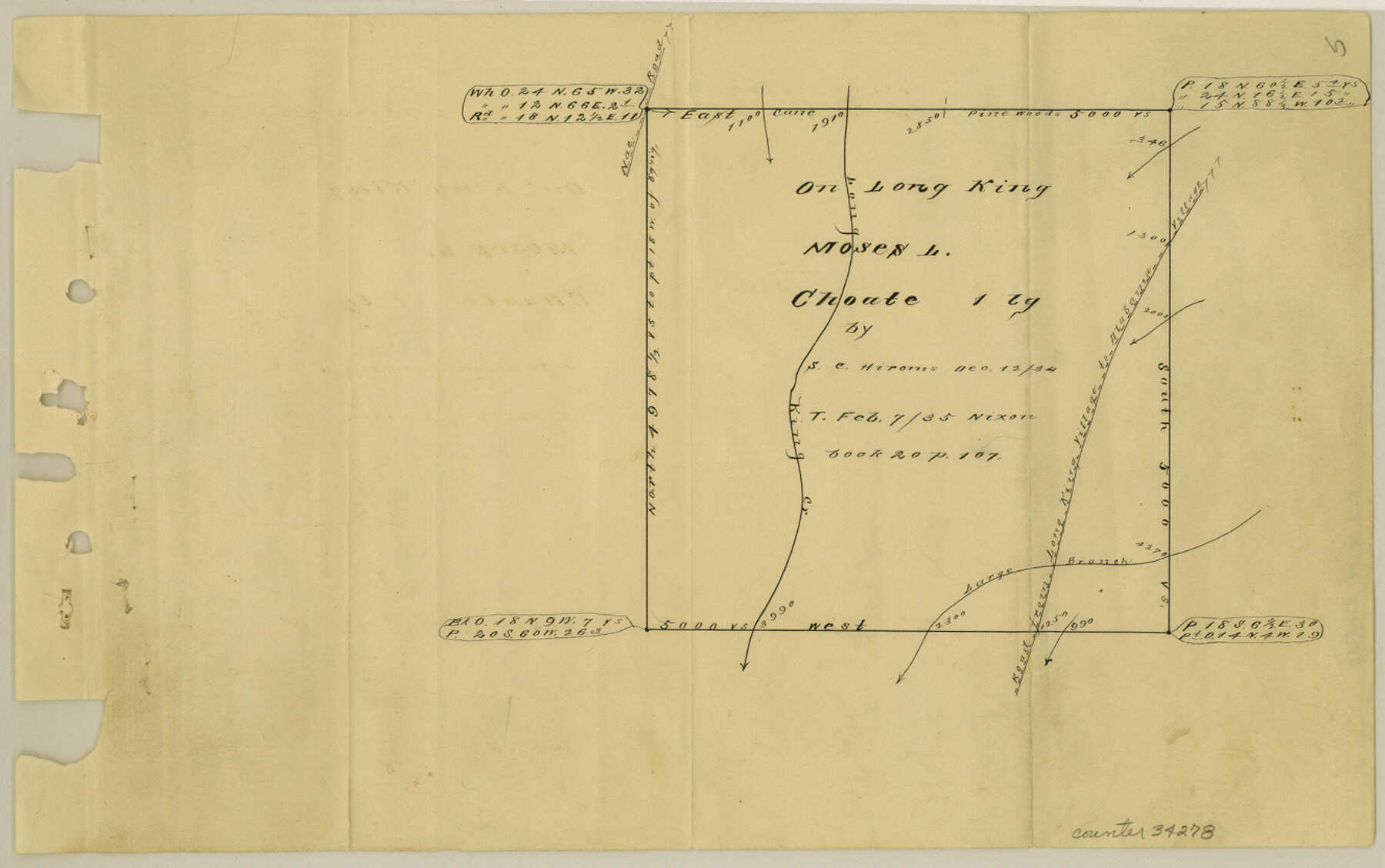
Polk County Sketch File 39
[Sketches and report of surveys on Long King Creek and surrounding surveys]
-
Map/Doc
34278
-
Collection
General Map Collection
-
People and Organizations
R.W. Hubert (Surveyor/Engineer)
Hiroms (Surveyor/Engineer)
J.M. Dikes (Surveyor/Engineer)
B.I. Willcoxon (Surveyor/Engineer)
W.H. Matthews (Surveyor/Engineer)
-
Counties
Polk
-
Subjects
Surveying Sketch File
-
Height x Width
8.3 x 13.3 inches
21.1 x 33.8 cm
-
Medium
multi-page, multi-format
-
Features
Long King Creek
Large Branch [of Long King Creek]
Tempe Creek
Road to Swartwout
Liberty Road
Clear Creek
Part of: General Map Collection
Galveston County NRC Article 33.136 Location Key Sheet

Print $20.00
- Digital $50.00
Galveston County NRC Article 33.136 Location Key Sheet
1994
Size 27.0 x 21.8 inches
Map/Doc 77019
Kimble County Working Sketch 77

Print $20.00
- Digital $50.00
Kimble County Working Sketch 77
1970
Size 25.0 x 36.2 inches
Map/Doc 70145
Map of Hopkins County

Print $20.00
- Digital $50.00
Map of Hopkins County
1863
Size 22.6 x 24.1 inches
Map/Doc 3679
Gaines County Working Sketch 14

Print $40.00
- Digital $50.00
Gaines County Working Sketch 14
1957
Size 62.3 x 31.7 inches
Map/Doc 69314
Plat of Resurvey of Sections 4, 9, 10 and 23, T. 5S., R. 13W., of the Indian Meridian, Oklahoma

Print $4.00
- Digital $50.00
Plat of Resurvey of Sections 4, 9, 10 and 23, T. 5S., R. 13W., of the Indian Meridian, Oklahoma
1917
Size 18.0 x 22.6 inches
Map/Doc 75143
Bandera County Working Sketch 21

Print $20.00
- Digital $50.00
Bandera County Working Sketch 21
1948
Size 21.1 x 16.7 inches
Map/Doc 67617
Val Verde County Working Sketch 117

Print $20.00
- Digital $50.00
Val Verde County Working Sketch 117
1993
Size 13.5 x 36.7 inches
Map/Doc 82847
Abandoned and Canceled Surveys - Volume 2 of 3, Counties E-K

Abandoned and Canceled Surveys - Volume 2 of 3, Counties E-K
Map/Doc 83249
Nueces County Sketch File 86

Print $2.00
- Digital $50.00
Nueces County Sketch File 86
Map/Doc 81935
Northeast Part of Crockett County

Print $20.00
- Digital $50.00
Northeast Part of Crockett County
1976
Size 35.6 x 47.0 inches
Map/Doc 95469
Harris County Working Sketch 98

Print $20.00
- Digital $50.00
Harris County Working Sketch 98
1979
Size 44.2 x 28.4 inches
Map/Doc 65990
Jones County Rolled Sketch 2

Print $40.00
- Digital $50.00
Jones County Rolled Sketch 2
2009
Size 48.0 x 34.0 inches
Map/Doc 93320
You may also like
Kendall County Sketch File 23

Print $40.00
- Digital $50.00
Kendall County Sketch File 23
1938
Size 15.5 x 15.9 inches
Map/Doc 28716
Brewster County Working Sketch 106

Print $20.00
- Digital $50.00
Brewster County Working Sketch 106
1980
Size 43.3 x 31.8 inches
Map/Doc 67706
Hudspeth County Rolled Sketch 61

Print $40.00
- Digital $50.00
Hudspeth County Rolled Sketch 61
1982
Size 71.3 x 45.1 inches
Map/Doc 9626
Northeast Part Presidio County

Print $20.00
- Digital $50.00
Northeast Part Presidio County
1973
Size 41.3 x 32.4 inches
Map/Doc 73265
Nueces County Rolled Sketch 115

Print $215.00
Nueces County Rolled Sketch 115
1992
Size 24.2 x 35.2 inches
Map/Doc 7126
Red River County Working Sketch 4

Print $20.00
- Digital $50.00
Red River County Working Sketch 4
1919
Size 19.7 x 18.8 inches
Map/Doc 71987
Flight Mission No. BRA-7M, Frame 32, Jefferson County

Print $20.00
- Digital $50.00
Flight Mission No. BRA-7M, Frame 32, Jefferson County
1953
Size 18.7 x 22.4 inches
Map/Doc 85483
Tom Green County Working Sketch 3

Print $20.00
- Digital $50.00
Tom Green County Working Sketch 3
1933
Size 47.5 x 40.2 inches
Map/Doc 69372
Primary Transportation Routes through Mexican Texas

Primary Transportation Routes through Mexican Texas
2024
Size 11.0 x 8.5 inches
Map/Doc 97463
[Sketch showing the Northwest part of Hale County and the Northeast part of Lamb County]
![93205, [Sketch showing the Northwest part of Hale County and the Northeast part of Lamb County], Twichell Survey Records](https://historictexasmaps.com/wmedia_w700/maps/93205-1.tif.jpg)
Print $40.00
- Digital $50.00
[Sketch showing the Northwest part of Hale County and the Northeast part of Lamb County]
Size 55.3 x 56.7 inches
Map/Doc 93205
Sherman Co., U. S. Public Land

Print $20.00
- Digital $50.00
Sherman Co., U. S. Public Land
Size 15.5 x 17.4 inches
Map/Doc 91895
Flight Mission No. CRK-8P, Frame 100, Refugio County

Print $20.00
- Digital $50.00
Flight Mission No. CRK-8P, Frame 100, Refugio County
1956
Size 18.2 x 22.0 inches
Map/Doc 86961