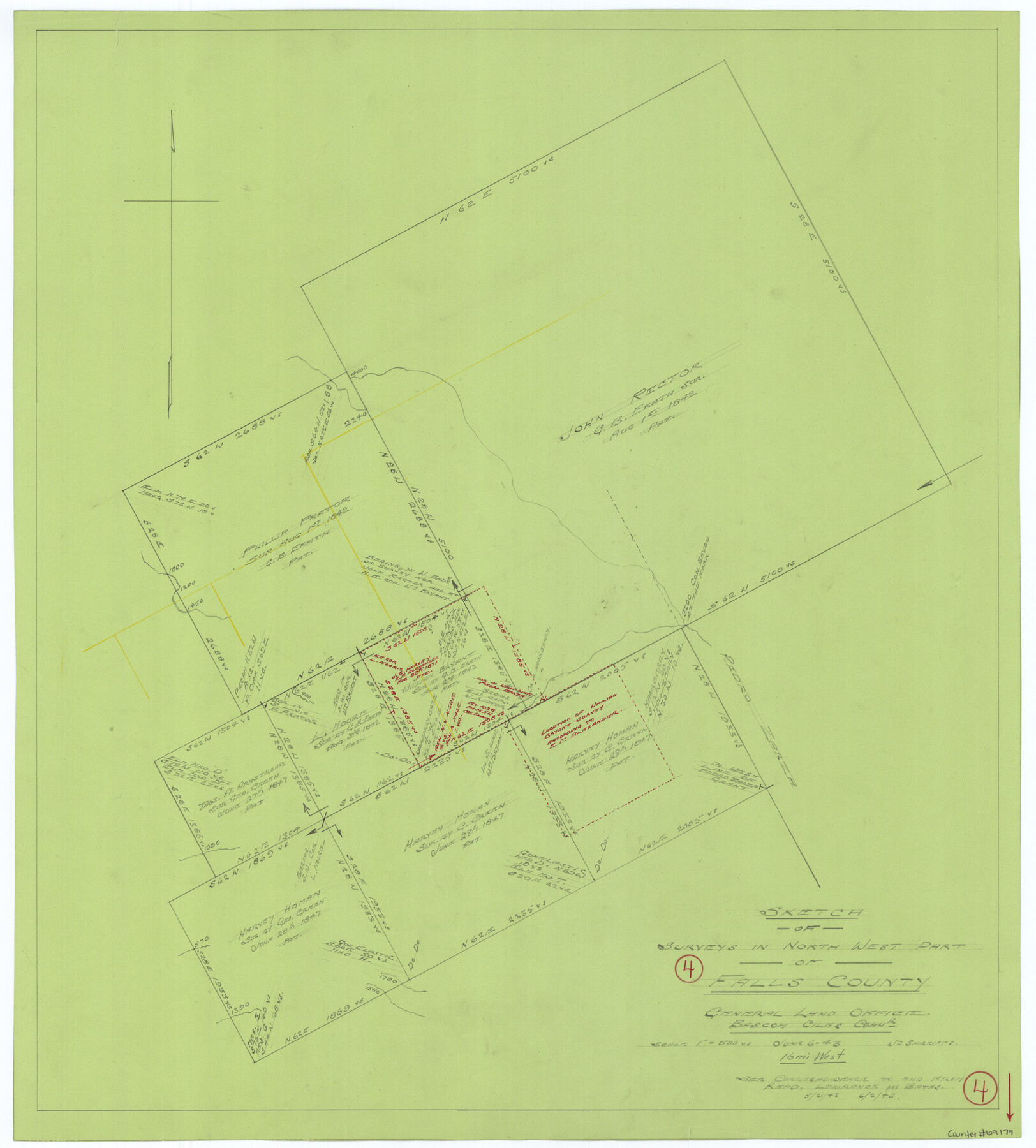
Falls County Working Sketch 4
-
Map/Doc
69179
-
Collection
General Map Collection
-
Object Dates
6/6/1943 (Creation Date)
-
People and Organizations
William Shirriffs (Draftsman)
-
Counties
Falls
-
Subjects
Surveying Working Sketch
-
Height x Width
24.3 x 22.0 inches
61.7 x 55.9 cm
-
Scale
1" = 500 varas
Part of: General Map Collection
Hutchinson County Working Sketch 40

Print $20.00
- Digital $50.00
Hutchinson County Working Sketch 40
1978
Size 27.0 x 22.4 inches
Map/Doc 66400
Brewster County Working Sketch 113

Print $20.00
- Digital $50.00
Brewster County Working Sketch 113
1982
Size 29.4 x 38.2 inches
Map/Doc 67713
El Paso County Sketch File 35 (2)

Print $18.00
- Digital $50.00
El Paso County Sketch File 35 (2)
1886
Size 12.9 x 8.3 inches
Map/Doc 22170
Flight Mission No. DIX-6P, Frame 113, Aransas County

Print $20.00
- Digital $50.00
Flight Mission No. DIX-6P, Frame 113, Aransas County
1956
Size 18.8 x 22.4 inches
Map/Doc 83819
Ward County Rolled Sketch 24F

Print $40.00
- Digital $50.00
Ward County Rolled Sketch 24F
Size 30.5 x 65.2 inches
Map/Doc 78232
King County Rolled Sketch 11

Print $20.00
- Digital $50.00
King County Rolled Sketch 11
1955
Size 40.2 x 46.6 inches
Map/Doc 9351
Armstrong County Working Sketch 1

Print $20.00
- Digital $50.00
Armstrong County Working Sketch 1
1903
Size 10.3 x 17.2 inches
Map/Doc 67232
Flight Mission No. BQR-22K, Frame 36, Brazoria County

Print $20.00
- Digital $50.00
Flight Mission No. BQR-22K, Frame 36, Brazoria County
1953
Size 18.6 x 22.4 inches
Map/Doc 84120
Freestone County Working Sketch 17

Print $20.00
- Digital $50.00
Freestone County Working Sketch 17
1980
Size 44.8 x 31.0 inches
Map/Doc 69259
Trinity River, North Extension Bazzette Sheet

Print $20.00
- Digital $50.00
Trinity River, North Extension Bazzette Sheet
1925
Size 16.3 x 24.3 inches
Map/Doc 69691
Harris County Working Sketch 112

Print $20.00
- Digital $50.00
Harris County Working Sketch 112
1982
Size 31.0 x 38.1 inches
Map/Doc 66004
Uvalde County Rolled Sketch 6

Print $20.00
- Digital $50.00
Uvalde County Rolled Sketch 6
Size 18.6 x 24.2 inches
Map/Doc 8091
You may also like
Schleicher County Working Sketch 26

Print $20.00
- Digital $50.00
Schleicher County Working Sketch 26
1962
Size 27.3 x 30.0 inches
Map/Doc 63828
Amistad International Reservoir on Rio Grande 66

Print $20.00
- Digital $50.00
Amistad International Reservoir on Rio Grande 66
1949
Size 28.5 x 39.6 inches
Map/Doc 73351
El Paso County Rolled Sketch 31

Print $20.00
- Digital $50.00
El Paso County Rolled Sketch 31
1908
Size 39.9 x 32.0 inches
Map/Doc 8858
New Map of Texas with the Contiguous American and Mexican States

Print $20.00
New Map of Texas with the Contiguous American and Mexican States
1835
Size 13.3 x 15.9 inches
Map/Doc 88894
Clay County Working Sketch 9

Print $20.00
- Digital $50.00
Clay County Working Sketch 9
1938
Size 37.5 x 29.4 inches
Map/Doc 68032
[Sketch in Southeast Part of County around J. H. Gibson Sections 1 and 2]
![91906, [Sketch in Southeast Part of County around J. H. Gibson Sections 1 and 2], Twichell Survey Records](https://historictexasmaps.com/wmedia_w700/maps/91906-1.tif.jpg)
Print $2.00
- Digital $50.00
[Sketch in Southeast Part of County around J. H. Gibson Sections 1 and 2]
Size 14.2 x 7.3 inches
Map/Doc 91906
Map of Louisiana, Texas, Arkansas and Indian Territory

Print $20.00
- Digital $50.00
Map of Louisiana, Texas, Arkansas and Indian Territory
1885
Size 9.0 x 12.2 inches
Map/Doc 93519
Bowie County Sketch File 10

Print $8.00
- Digital $50.00
Bowie County Sketch File 10
1992
Size 11.1 x 8.8 inches
Map/Doc 14912
Webb County Boundary File 3

Print $74.00
- Digital $50.00
Webb County Boundary File 3
Size 11.3 x 8.8 inches
Map/Doc 59716
Leon County Rolled Sketch 1

Print $20.00
- Digital $50.00
Leon County Rolled Sketch 1
Size 25.8 x 32.5 inches
Map/Doc 6594
Nebraska and Kansas

Print $20.00
- Digital $50.00
Nebraska and Kansas
Size 14.7 x 16.7 inches
Map/Doc 93997
Pecos County Working Sketch 119

Print $20.00
- Digital $50.00
Pecos County Working Sketch 119
1973
Size 42.8 x 30.9 inches
Map/Doc 71592