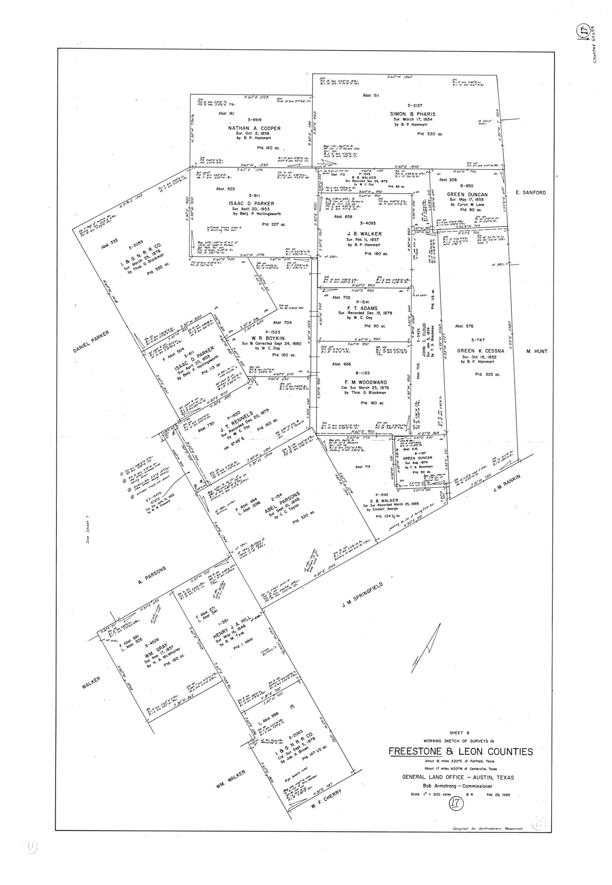
Freestone County Working Sketch 17
-
Map/Doc
69259
-
Collection
General Map Collection
-
Object Dates
2/28/1980 (Creation Date)
-
People and Organizations
Beverly Robison (Draftsman)
-
Counties
Freestone Leon
-
Subjects
Surveying Working Sketch
-
Height x Width
44.8 x 31.0 inches
113.8 x 78.7 cm
-
Scale
1" = 200 varas
Part of: General Map Collection
Nacogdoches County Sketch File 21

Print $20.00
- Digital $50.00
Nacogdoches County Sketch File 21
1837
Size 9.4 x 5.5 inches
Map/Doc 32286
Cooke County Sketch File 13

Print $20.00
- Digital $50.00
Cooke County Sketch File 13
1859
Size 27.1 x 19.0 inches
Map/Doc 11171

Flight Mission No. CLL-3N, Frame 35, Willacy County

Print $20.00
- Digital $50.00
Flight Mission No. CLL-3N, Frame 35, Willacy County
1954
Size 18.3 x 22.1 inches
Map/Doc 87093
Nueces County Rolled Sketch 79

Print $20.00
- Digital $50.00
Nueces County Rolled Sketch 79
1894
Size 38.1 x 31.3 inches
Map/Doc 9627
Red River County Working Sketch 17

Print $20.00
- Digital $50.00
Red River County Working Sketch 17
1954
Size 23.2 x 18.8 inches
Map/Doc 72000
[Gonzales District]
![16837, [Gonzales District], General Map Collection](https://historictexasmaps.com/wmedia_w700/maps/16837.tif.jpg)
Print $20.00
- Digital $50.00
[Gonzales District]
1840
Size 42.8 x 37.0 inches
Map/Doc 16837
Concho County Sketch File 38

Print $4.00
- Digital $50.00
Concho County Sketch File 38
1938
Size 14.6 x 9.0 inches
Map/Doc 19188
Flight Mission No. DQN-2K, Frame 115, Calhoun County

Print $20.00
- Digital $50.00
Flight Mission No. DQN-2K, Frame 115, Calhoun County
1953
Size 18.6 x 22.3 inches
Map/Doc 84291
Harris County

Print $40.00
- Digital $50.00
Harris County
1896
Size 44.8 x 67.5 inches
Map/Doc 66856
Baylor County Sketch File 11A

Print $40.00
- Digital $50.00
Baylor County Sketch File 11A
Size 33.9 x 32.0 inches
Map/Doc 10322
Anderson County Working Sketch Graphic Index

Print $40.00
- Digital $50.00
Anderson County Working Sketch Graphic Index
1942
Size 52.0 x 48.3 inches
Map/Doc 76452
You may also like
[Littlefield Subdivision Blocks 657-687]
![91008, [Littlefield Subdivision Blocks 657-687], Twichell Survey Records](https://historictexasmaps.com/wmedia_w700/maps/91008-1.tif.jpg)
Print $20.00
- Digital $50.00
[Littlefield Subdivision Blocks 657-687]
Size 15.7 x 12.1 inches
Map/Doc 91008
Comanche County Sketch File 18

Print $4.00
- Digital $50.00
Comanche County Sketch File 18
Size 8.4 x 7.8 inches
Map/Doc 19091
General Highway Map, Washington County, Texas

Print $20.00
General Highway Map, Washington County, Texas
1940
Size 18.4 x 25.0 inches
Map/Doc 79272
Dallas County Working Sketch 15

Print $20.00
- Digital $50.00
Dallas County Working Sketch 15
1980
Size 14.3 x 11.4 inches
Map/Doc 68581
[Movements & Objectives of the 143rd & 144th Infantry on October 12-13, 1918] - Verso
![94136, [Movements & Objectives of the 143rd & 144th Infantry on October 12-13, 1918] - Verso, Non-GLO Digital Images](https://historictexasmaps.com/wmedia_w700/maps/94136-1.tif.jpg)
Print $20.00
[Movements & Objectives of the 143rd & 144th Infantry on October 12-13, 1918] - Verso
1918
Size 42.4 x 30.0 inches
Map/Doc 94136
Wharton County Working Sketch 15

Print $20.00
- Digital $50.00
Wharton County Working Sketch 15
1957
Size 22.1 x 25.9 inches
Map/Doc 72479
Travis County Boundary File 32

Print $5.00
- Digital $50.00
Travis County Boundary File 32
Size 11.8 x 9.4 inches
Map/Doc 59473
Map of survey made for Ingham S. Roberts on Application No. 147, SF-9177 containing 413.78 acres, 4 mi SE of Houston, Harris Co. Texas

Print $20.00
- Digital $50.00
Map of survey made for Ingham S. Roberts on Application No. 147, SF-9177 containing 413.78 acres, 4 mi SE of Houston, Harris Co. Texas
1910
Size 37.3 x 31.0 inches
Map/Doc 373

Flight Mission No. BRE-1P, Frame 71, Nueces County

Print $20.00
- Digital $50.00
Flight Mission No. BRE-1P, Frame 71, Nueces County
1956
Size 18.6 x 22.2 inches
Map/Doc 86653
Kimble County Boundary File 3

Print $44.00
- Digital $50.00
Kimble County Boundary File 3
Size 9.8 x 32.4 inches
Map/Doc 64846
