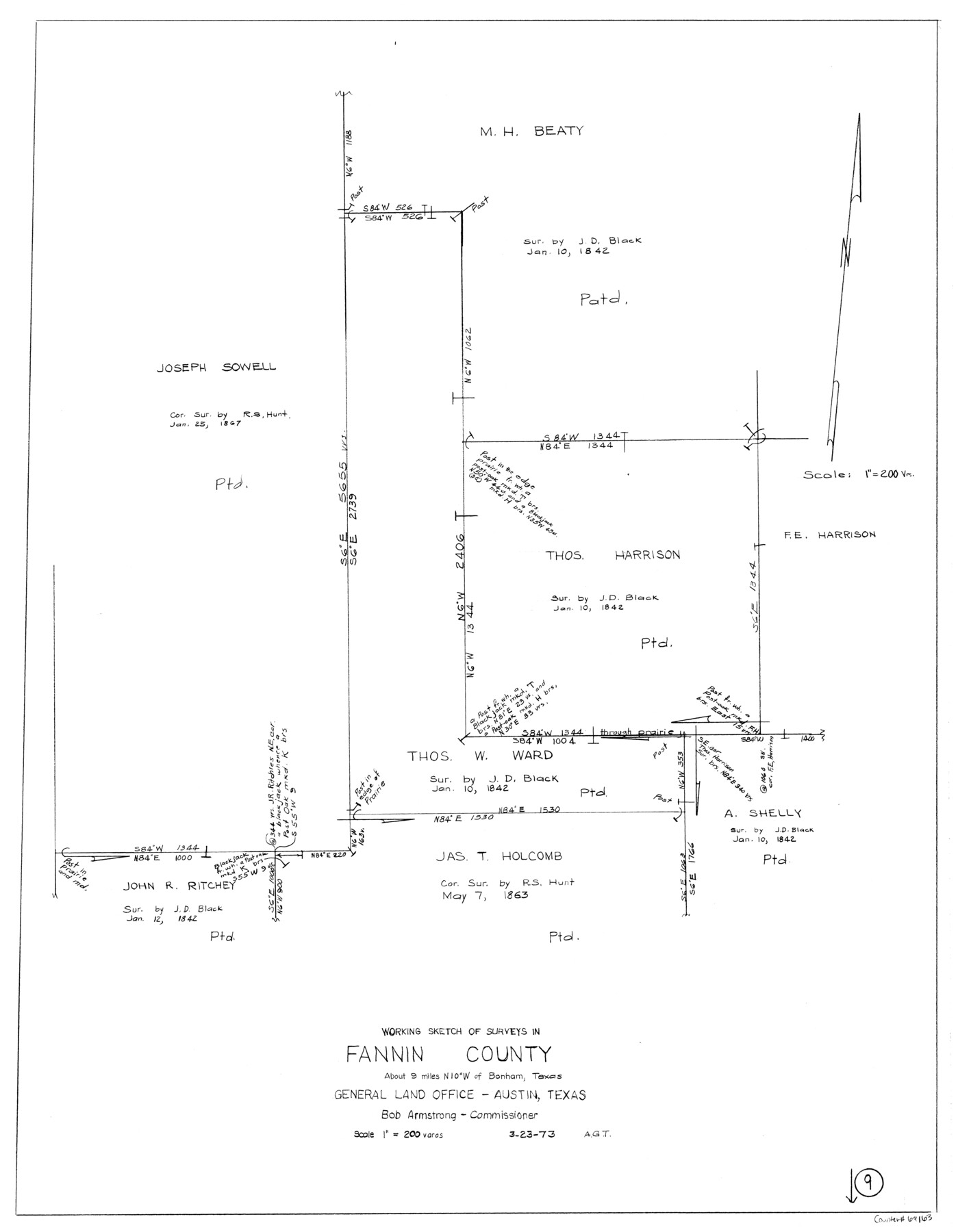
Fannin County Working Sketch 9
-
Map/Doc
69163
-
Collection
General Map Collection
-
Object Dates
3/23/1973 (Creation Date)
-
People and Organizations
Abner G. Trigg (Draftsman)
-
Counties
Fannin
-
Subjects
Surveying Working Sketch
-
Height x Width
28.1 x 21.9 inches
71.4 x 55.6 cm
-
Scale
1" = 200 varas
Part of: General Map Collection
Crane County Working Sketch 1

Print $20.00
- Digital $50.00
Crane County Working Sketch 1
1906
Size 30.5 x 27.0 inches
Map/Doc 68278
Ector County Sketch File 13

Print $16.00
- Digital $50.00
Ector County Sketch File 13
1988
Size 11.5 x 9.0 inches
Map/Doc 21651
[Surveys in the Montgomery District: San Jacinto River and Caney Creek, Navidad, Navasota]
![33, [Surveys in the Montgomery District: San Jacinto River and Caney Creek, Navidad, Navasota], General Map Collection](https://historictexasmaps.com/wmedia_w700/maps/33.tif.jpg)
Print $2.00
- Digital $50.00
[Surveys in the Montgomery District: San Jacinto River and Caney Creek, Navidad, Navasota]
1846
Size 8.8 x 6.0 inches
Map/Doc 33
Coleman County Sketch File 34

Print $28.00
- Digital $50.00
Coleman County Sketch File 34
1878
Size 12.8 x 8.1 inches
Map/Doc 18726
Concho County Sketch File 2

Print $4.00
- Digital $50.00
Concho County Sketch File 2
1859
Size 10.5 x 8.5 inches
Map/Doc 19122
Hamilton County Working Sketch 17

Print $20.00
- Digital $50.00
Hamilton County Working Sketch 17
1951
Size 44.4 x 25.0 inches
Map/Doc 63355
Hays County Sketch File 16

Print $4.00
- Digital $50.00
Hays County Sketch File 16
1857
Size 12.8 x 8.3 inches
Map/Doc 26227
Harrison County Working Sketch 14

Print $20.00
- Digital $50.00
Harrison County Working Sketch 14
1961
Size 35.6 x 32.0 inches
Map/Doc 66034
Cooke County Sketch File 24

Print $6.00
- Digital $50.00
Cooke County Sketch File 24
1871
Size 10.3 x 8.3 inches
Map/Doc 19272

Polk County Sketch File 25

Print $46.00
- Digital $50.00
Polk County Sketch File 25
Size 5.7 x 28.2 inches
Map/Doc 34176
Wilson County Boundary File 1

Print $58.00
- Digital $50.00
Wilson County Boundary File 1
Size 9.6 x 4.5 inches
Map/Doc 60058
You may also like
Flight Mission No. DAG-17K, Frame 64, Matagorda County

Print $20.00
- Digital $50.00
Flight Mission No. DAG-17K, Frame 64, Matagorda County
1952
Size 16.5 x 16.4 inches
Map/Doc 86326
Map of Robertson County

Print $20.00
- Digital $50.00
Map of Robertson County
1888
Size 29.1 x 23.9 inches
Map/Doc 83004
United States Atlantic and Gulf Coasts Including Puerto Rico and the Virgin Islands

Print $40.00
- Digital $50.00
United States Atlantic and Gulf Coasts Including Puerto Rico and the Virgin Islands
1973
Size 21.5 x 60.4 inches
Map/Doc 76126
Jack County Sketch File 26

Print $4.00
- Digital $50.00
Jack County Sketch File 26
1891
Size 8.7 x 9.3 inches
Map/Doc 27563
Map of Freeport, Brazoria County, Texas

Print $20.00
- Digital $50.00
Map of Freeport, Brazoria County, Texas
Size 27.0 x 39.1 inches
Map/Doc 7689
Current Miscellaneous File 20

Print $22.00
- Digital $50.00
Current Miscellaneous File 20
1952
Size 10.7 x 8.1 inches
Map/Doc 73855
Sketch of Liberty County

Print $2.00
- Digital $50.00
Sketch of Liberty County
1841
Size 6.8 x 8.1 inches
Map/Doc 160
Kinney County Rolled Sketch 8

Print $20.00
- Digital $50.00
Kinney County Rolled Sketch 8
Size 28.0 x 43.9 inches
Map/Doc 6537
North Tech Addition, Section 18, Block A

Print $20.00
- Digital $50.00
North Tech Addition, Section 18, Block A
1952
Size 17.9 x 23.0 inches
Map/Doc 92756
Hansford County

Print $20.00
- Digital $50.00
Hansford County
1932
Size 39.7 x 39.0 inches
Map/Doc 95519
Ward County Rolled Sketch 12

Print $20.00
- Digital $50.00
Ward County Rolled Sketch 12
Size 38.2 x 47.8 inches
Map/Doc 10107
Anderson County Sketch File 18

Print $40.00
- Digital $50.00
Anderson County Sketch File 18
1880
Size 16.0 x 13.5 inches
Map/Doc 10801