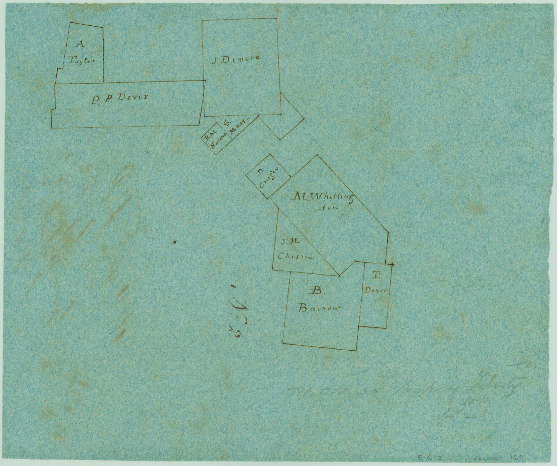
Sketch of Liberty County
Atlas E, Page 6, Sketch 2 (E-6-2)
E-6-2
-
Map/Doc
160
-
Collection
General Map Collection
-
Object Dates
1841 (Creation Date)
-
Counties
Liberty
-
Subjects
Atlas
-
Height x Width
6.8 x 8.1 inches
17.3 x 20.6 cm
-
Medium
paper, manuscript
-
Scale
[1:4000]
-
Comments
Conserved in 2004.
Part of: General Map Collection
Cherokee County Working Sketch 9

Print $20.00
- Digital $50.00
Cherokee County Working Sketch 9
1957
Size 46.9 x 34.0 inches
Map/Doc 67964
[Anderson County]
![5051, [Anderson County], General Map Collection](https://historictexasmaps.com/wmedia_w700/maps/5051-GC.tif.jpg)
Print $20.00
- Digital $50.00
[Anderson County]
1848
Size 26.0 x 19.9 inches
Map/Doc 5051
[Sketch with field note calls of the boundaries of Webb, Duval, Jim Wells,Nueces, Kleberg, Zapata, Jim Hogg, Brooks, Willacy, Starr, Hidalgo and Cameron Counties]
![1689, [Sketch with field note calls of the boundaries of Webb, Duval, Jim Wells,Nueces, Kleberg, Zapata, Jim Hogg, Brooks, Willacy, Starr, Hidalgo and Cameron Counties], General Map Collection](https://historictexasmaps.com/wmedia_w700/pdf_converted_jpg/qi_pdf_thumbnail_720.jpg)
Print $20.00
- Digital $50.00
[Sketch with field note calls of the boundaries of Webb, Duval, Jim Wells,Nueces, Kleberg, Zapata, Jim Hogg, Brooks, Willacy, Starr, Hidalgo and Cameron Counties]
1915
Size 21.9 x 26.2 inches
Map/Doc 1689
Montgomery County Working Sketch 27

Print $20.00
- Digital $50.00
Montgomery County Working Sketch 27
1942
Size 42.1 x 33.4 inches
Map/Doc 71134
Young Territory

Print $20.00
- Digital $50.00
Young Territory
1874
Size 29.4 x 29.2 inches
Map/Doc 1977
Comal County Working Sketch 8

Print $20.00
- Digital $50.00
Comal County Working Sketch 8
1971
Size 41.6 x 25.6 inches
Map/Doc 68174
Kerr County Sketch File 22

Print $8.00
- Digital $50.00
Kerr County Sketch File 22
Size 11.3 x 8.7 inches
Map/Doc 28897
Flight Mission No. DQO-7K, Frame 82, Galveston County

Print $20.00
- Digital $50.00
Flight Mission No. DQO-7K, Frame 82, Galveston County
1952
Size 18.8 x 22.5 inches
Map/Doc 85109

Map of Van Zandt County

Print $20.00
- Digital $50.00
Map of Van Zandt County
1853
Size 19.4 x 20.6 inches
Map/Doc 16957
Hunt County Sketch File 32

Print $6.00
- Digital $50.00
Hunt County Sketch File 32
Size 7.9 x 11.6 inches
Map/Doc 27138
Wichita County Sketch File 32

Print $12.00
- Digital $50.00
Wichita County Sketch File 32
1939
Size 14.2 x 8.8 inches
Map/Doc 40146
You may also like
Map of a Part of Lea County, New Mexico

Print $40.00
- Digital $50.00
Map of a Part of Lea County, New Mexico
Size 60.5 x 42.0 inches
Map/Doc 89910
Map showing the John B. Pier Survey, Near Houston

Print $3.00
- Digital $50.00
Map showing the John B. Pier Survey, Near Houston
Size 11.9 x 17.8 inches
Map/Doc 478
Geological Map of the United States and the British Provinces of North America

Print $20.00
- Digital $50.00
Geological Map of the United States and the British Provinces of North America
Size 23.4 x 35.9 inches
Map/Doc 93988
Aransas County Rolled Sketch 7

Print $437.00
- Digital $50.00
Aransas County Rolled Sketch 7
Map/Doc 42081
Working Sketch compiled from original field notes showing surveys in Reagan and Irion Counties located by Frank Lerch in 1883 and 1884, also adjacent blocks and surveys (previously located by other surveyors) called for in his Field Notes

Print $20.00
- Digital $50.00
Working Sketch compiled from original field notes showing surveys in Reagan and Irion Counties located by Frank Lerch in 1883 and 1884, also adjacent blocks and surveys (previously located by other surveyors) called for in his Field Notes
1883
Size 35.8 x 20.0 inches
Map/Doc 91749
Bee County Working Sketch 9

Print $20.00
- Digital $50.00
Bee County Working Sketch 9
1940
Size 15.6 x 16.8 inches
Map/Doc 67259
Brazoria County Sketch File 19

Print $36.00
- Digital $50.00
Brazoria County Sketch File 19
1913
Size 8.8 x 5.5 inches
Map/Doc 14998
Flight Mission No. CLL-1N, Frame 186, Willacy County

Print $20.00
- Digital $50.00
Flight Mission No. CLL-1N, Frame 186, Willacy County
1954
Size 18.4 x 22.1 inches
Map/Doc 87056
Dimmit County Sketch File 36

Print $6.00
- Digital $50.00
Dimmit County Sketch File 36
1894
Size 4.3 x 13.3 inches
Map/Doc 21158
[Gunter & Munson Maddox Bros. & Anderson Blocks F, O, N, A and vicinity]
![93203, [Gunter & Munson Maddox Bros. & Anderson Blocks F, O, N, A and vicinity], Twichell Survey Records](https://historictexasmaps.com/wmedia_w700/maps/93203-1.tif.jpg)
Print $40.00
- Digital $50.00
[Gunter & Munson Maddox Bros. & Anderson Blocks F, O, N, A and vicinity]
1929
Size 81.0 x 15.2 inches
Map/Doc 93203
Tyler County Rolled Sketch 7

Print $20.00
- Digital $50.00
Tyler County Rolled Sketch 7
1960
Size 40.0 x 46.5 inches
Map/Doc 10030
Navigation Maps of Gulf Intracoastal Waterway, Port Arthur to Brownsville, Texas

Print $4.00
- Digital $50.00
Navigation Maps of Gulf Intracoastal Waterway, Port Arthur to Brownsville, Texas
1951
Size 16.6 x 21.5 inches
Map/Doc 65430