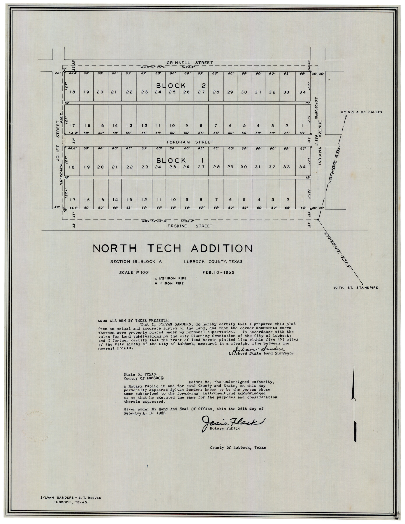
North Tech Addition, Section 18, Block A
-
Map/Doc
92756
-
Collection
Twichell Survey Records
-
Object Dates
2/10/1952 (Creation Date)
-
People and Organizations
Sylvan Sanders (Surveyor/Engineer)
-
Counties
Lubbock
-
Height x Width
17.9 x 23.0 inches
45.5 x 58.4 cm
Part of: Twichell Survey Records
[Sketch highlighting Bob Reid and Fred Turner surveys]
![91694, [Sketch highlighting Bob Reid and Fred Turner surveys], Twichell Survey Records](https://historictexasmaps.com/wmedia_w700/maps/91694-1.tif.jpg)
Print $20.00
- Digital $50.00
[Sketch highlighting Bob Reid and Fred Turner surveys]
Size 12.5 x 17.6 inches
Map/Doc 91694
[H. & T. C. Block 47, Sections 47- 57, Part of Block B12]
![91527, [H. & T. C. Block 47, Sections 47- 57, Part of Block B12], Twichell Survey Records](https://historictexasmaps.com/wmedia_w700/maps/91527-1.tif.jpg)
Print $20.00
- Digital $50.00
[H. & T. C. Block 47, Sections 47- 57, Part of Block B12]
Size 16.2 x 22.6 inches
Map/Doc 91527
Plat of South Side Addition on Section 37 Block 17, Wheeler County, Texas

Print $20.00
- Digital $50.00
Plat of South Side Addition on Section 37 Block 17, Wheeler County, Texas
Size 12.0 x 16.9 inches
Map/Doc 92103
[Block XR, Capitol Leagues 161, 162, 164, 174, 178, 179, and 180]
![90661, [Block XR, Capitol Leagues 161, 162, 164, 174, 178, 179, and 180], Twichell Survey Records](https://historictexasmaps.com/wmedia_w700/maps/90661-1.tif.jpg)
Print $20.00
- Digital $50.00
[Block XR, Capitol Leagues 161, 162, 164, 174, 178, 179, and 180]
1908
Size 12.3 x 21.1 inches
Map/Doc 90661
John H. Stephens Block S2, State Capitol Leagues

Print $20.00
- Digital $50.00
John H. Stephens Block S2, State Capitol Leagues
Size 28.6 x 23.2 inches
Map/Doc 92995
[H. & G. N. Block B4]
![90275, [H. & G. N. Block B4], Twichell Survey Records](https://historictexasmaps.com/wmedia_w700/maps/90275-1.tif.jpg)
Print $20.00
- Digital $50.00
[H. & G. N. Block B4]
Size 21.4 x 18.2 inches
Map/Doc 90275
[Hutchinson County Resurveys South of the Canadian River]
![91166, [Hutchinson County Resurveys South of the Canadian River], Twichell Survey Records](https://historictexasmaps.com/wmedia_w700/maps/91166-1.tif.jpg)
Print $20.00
- Digital $50.00
[Hutchinson County Resurveys South of the Canadian River]
1920
Size 33.3 x 21.1 inches
Map/Doc 91166
[H. & G. N. Block 1]
![90940, [H. & G. N. Block 1], Twichell Survey Records](https://historictexasmaps.com/wmedia_w700/maps/90940-1.tif.jpg)
Print $20.00
- Digital $50.00
[H. & G. N. Block 1]
1873
Size 17.3 x 14.2 inches
Map/Doc 90940
[Sketch of sections 59-64, I. & G. N. Block 1 and part of Block Z]
![93167, [Sketch of sections 59-64, I. & G. N. Block 1 and part of Block Z], Twichell Survey Records](https://historictexasmaps.com/wmedia_w700/maps/93167-1.tif.jpg)
Print $40.00
- Digital $50.00
[Sketch of sections 59-64, I. & G. N. Block 1 and part of Block Z]
Size 74.8 x 43.5 inches
Map/Doc 93167
Brazos River Conservation and Reclamation District Official Boundary Line Survey, Parmer County

Print $20.00
- Digital $50.00
Brazos River Conservation and Reclamation District Official Boundary Line Survey, Parmer County
Size 24.6 x 16.8 inches
Map/Doc 91659
Section M, Tech Memorial Park, Inc.

Print $3.00
- Digital $50.00
Section M, Tech Memorial Park, Inc.
1950
Size 11.2 x 17.3 inches
Map/Doc 92784
Crawford Farm S 1/2 Section 59, Block A

Print $3.00
- Digital $50.00
Crawford Farm S 1/2 Section 59, Block A
Size 16.5 x 9.9 inches
Map/Doc 92337
You may also like
Waller County

Print $20.00
- Digital $50.00
Waller County
1897
Size 46.0 x 30.2 inches
Map/Doc 63107
Map from Corpus Christi to Matagorda Bays, Texas [Inset: Survey of the channel of Copono Bay]
![72976, Map from Corpus Christi to Matagorda Bays, Texas [Inset: Survey of the channel of Copono Bay], General Map Collection](https://historictexasmaps.com/wmedia_w700/maps/72976.tif.jpg)
Print $20.00
- Digital $50.00
Map from Corpus Christi to Matagorda Bays, Texas [Inset: Survey of the channel of Copono Bay]
1846
Size 18.1 x 27.5 inches
Map/Doc 72976
Kenedy County Working Sketch 2b

Print $20.00
- Digital $50.00
Kenedy County Working Sketch 2b
1911
Size 17.7 x 33.3 inches
Map/Doc 70004
Shelby County Working Sketch 18

Print $20.00
- Digital $50.00
Shelby County Working Sketch 18
1957
Size 20.7 x 27.4 inches
Map/Doc 63871
Val Verde County Sketch File 41

Print $20.00
- Digital $50.00
Val Verde County Sketch File 41
1938
Size 17.8 x 22.7 inches
Map/Doc 12583
Texas Coordinate File 5

Print $4.00
- Digital $50.00
Texas Coordinate File 5
Size 11.2 x 8.7 inches
Map/Doc 75312
Edwards County

Print $20.00
- Digital $50.00
Edwards County
1893
Size 26.7 x 30.2 inches
Map/Doc 4650
Gray County Boundary File 3a

Print $4.00
- Digital $50.00
Gray County Boundary File 3a
Size 14.2 x 8.8 inches
Map/Doc 53874
Bexar County Working Sketch 4

Print $20.00
- Digital $50.00
Bexar County Working Sketch 4
1941
Size 19.4 x 21.7 inches
Map/Doc 67320

Baylor County Rolled Sketch 5

Print $20.00
- Digital $50.00
Baylor County Rolled Sketch 5
1874
Size 43.2 x 39.7 inches
Map/Doc 8444
Shallowater Well Field Survey

Print $40.00
- Digital $50.00
Shallowater Well Field Survey
Size 61.8 x 43.7 inches
Map/Doc 89900