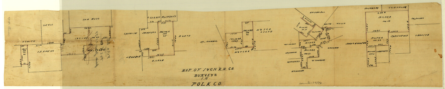
Polk County Sketch File 25
[Sketches of I.& G.N. RR. Co. surveys, and sketch of H.&T.C. RR. Co. surveys in northeastern part of county]
-
Map/Doc
34176
-
Collection
General Map Collection
-
Object Dates
1/22/1877 (File Date)
-
Counties
Polk
-
Subjects
Surveying Sketch File
-
Height x Width
5.7 x 28.2 inches
14.5 x 71.6 cm
-
Medium
paper, manuscript
Part of: General Map Collection
Presidio County Rolled Sketch 68

Print $20.00
- Digital $50.00
Presidio County Rolled Sketch 68
1927
Size 11.8 x 24.4 inches
Map/Doc 7358
Kinney County Working Sketch 12

Print $20.00
- Digital $50.00
Kinney County Working Sketch 12
1941
Size 26.7 x 32.1 inches
Map/Doc 70194
San Jacinto County Working Sketch 45

Print $20.00
- Digital $50.00
San Jacinto County Working Sketch 45
1986
Size 41.0 x 46.7 inches
Map/Doc 63759
Hunt County Rolled Sketch 5

Print $20.00
- Digital $50.00
Hunt County Rolled Sketch 5
1966
Size 24.7 x 24.5 inches
Map/Doc 6275
Crane County Rolled Sketch 23

Print $20.00
- Digital $50.00
Crane County Rolled Sketch 23
2002
Size 23.9 x 34.3 inches
Map/Doc 76426
Burnet County Working Sketch Graphic Index

Print $20.00
- Digital $50.00
Burnet County Working Sketch Graphic Index
1924
Size 46.5 x 41.2 inches
Map/Doc 76482

Flight Mission No. BRE-1P, Frame 127, Nueces County

Print $20.00
- Digital $50.00
Flight Mission No. BRE-1P, Frame 127, Nueces County
1956
Size 18.7 x 22.6 inches
Map/Doc 86693
Clay County Working Sketch 9

Print $20.00
- Digital $50.00
Clay County Working Sketch 9
1938
Size 37.5 x 29.4 inches
Map/Doc 68032
Flight Mission No. CUG-3P, Frame 13, Kleberg County

Print $20.00
- Digital $50.00
Flight Mission No. CUG-3P, Frame 13, Kleberg County
1956
Size 18.6 x 22.1 inches
Map/Doc 86223
San Augustine County Working Sketch 4

Print $20.00
- Digital $50.00
San Augustine County Working Sketch 4
1934
Size 24.4 x 27.7 inches
Map/Doc 63691
Starr County Working Sketch Graphic Index

Print $40.00
- Digital $50.00
Starr County Working Sketch Graphic Index
1977
Size 43.0 x 55.5 inches
Map/Doc 76701
You may also like
Township No. 2 South Range No. 20 West of the Indian Meridian

Print $20.00
- Digital $50.00
Township No. 2 South Range No. 20 West of the Indian Meridian
1875
Size 19.2 x 24.5 inches
Map/Doc 75180
Runnels County Sketch File 8

Print $40.00
Runnels County Sketch File 8
Size 37.9 x 37.5 inches
Map/Doc 10591
Maps & Lists Showing Prison Lands (Oil & Gas) Leased as of June 1955

Digital $50.00
Maps & Lists Showing Prison Lands (Oil & Gas) Leased as of June 1955
Size 11.2 x 8.7 inches
Map/Doc 62871
Delta County Sketch File 1

Print $4.00
- Digital $50.00
Delta County Sketch File 1
1871
Size 12.7 x 8.1 inches
Map/Doc 20666
Limestone County Sketch File 23

Print $6.00
- Digital $50.00
Limestone County Sketch File 23
1908
Size 10.9 x 7.1 inches
Map/Doc 30203
Roberts County Working Sketch 34

Print $20.00
- Digital $50.00
Roberts County Working Sketch 34
1978
Size 26.6 x 22.5 inches
Map/Doc 63560
Rhyne Simpson Addition No. 2, City of Lubbock Section 3, Block O

Print $20.00
- Digital $50.00
Rhyne Simpson Addition No. 2, City of Lubbock Section 3, Block O
1957
Size 11.7 x 18.2 inches
Map/Doc 92752

Jefferson County NRC Article 33.136 Sketch 10

Print $28.00
- Digital $50.00
Jefferson County NRC Article 33.136 Sketch 10
2012
Size 24.0 x 36.0 inches
Map/Doc 94575
Index Map No. 1 - Rio Bravo del Norte section of boundary between the United States & Mexico; agreed upon by the Joint Commission under the Treaty of Guadalupe Hidalgo

Print $20.00
- Digital $50.00
Index Map No. 1 - Rio Bravo del Norte section of boundary between the United States & Mexico; agreed upon by the Joint Commission under the Treaty of Guadalupe Hidalgo
1852
Size 18.3 x 27.5 inches
Map/Doc 72860
Oldham County Sketch File 3

Print $12.00
- Digital $50.00
Oldham County Sketch File 3
1883
Size 8.2 x 7.8 inches
Map/Doc 33228
Northern Part of Laguna Madre

Print $20.00
- Digital $50.00
Northern Part of Laguna Madre
1965
Size 44.5 x 35.0 inches
Map/Doc 73526