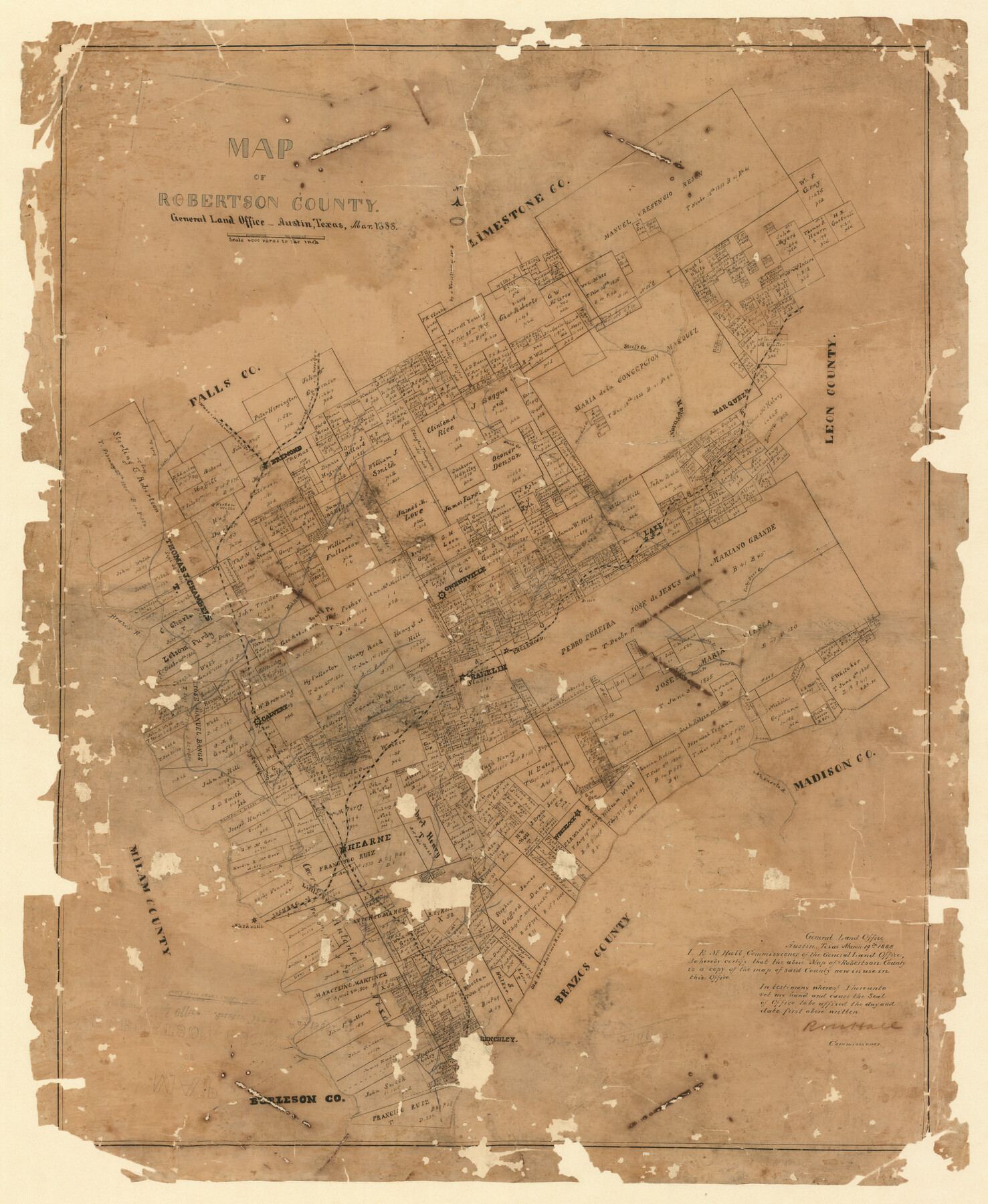
Map of Robertson County
-
Map/Doc
83004
-
Collection
General Map Collection
-
Object Dates
1888 (Creation Date)
-
People and Organizations
Cathy Lazarus (Donor)
R.M. Hall (GLO Commissioner)
-
Counties
Robertson
-
Subjects
County
-
Height x Width
29.1 x 23.9 inches
73.9 x 60.7 cm
-
Comments
Donated by Cathy Lazarus, Robertson County Historical Commission.
Conservation funded in 2006 by Friends of the Texas General Land Office.
Part of: General Map Collection
Mills County Working Sketch 9

Print $20.00
- Digital $50.00
Mills County Working Sketch 9
1915
Size 13.3 x 13.7 inches
Map/Doc 71039
Nolan County Sketch File D1

Print $42.00
- Digital $50.00
Nolan County Sketch File D1
1904
Size 19.5 x 18.8 inches
Map/Doc 42173
Anderson County Working Sketch 40

Print $20.00
- Digital $50.00
Anderson County Working Sketch 40
1986
Size 17.0 x 20.3 inches
Map/Doc 67040
Map of University Land in Shackelford and Callahan Counties

Print $20.00
- Digital $50.00
Map of University Land in Shackelford and Callahan Counties
1905
Size 33.4 x 25.3 inches
Map/Doc 2435
Hutchinson County Rolled Sketch 44-13

Print $20.00
- Digital $50.00
Hutchinson County Rolled Sketch 44-13
2002
Size 24.0 x 36.0 inches
Map/Doc 77549
Kinney County Sketch File 30

Print $10.00
- Digital $50.00
Kinney County Sketch File 30
1933
Size 11.3 x 8.7 inches
Map/Doc 29171
Geological Highway Map of Texas

Geological Highway Map of Texas
1973
Size 27.9 x 36.5 inches
Map/Doc 77523
Map of Harris County

Print $40.00
- Digital $50.00
Map of Harris County
1897
Size 48.4 x 66.9 inches
Map/Doc 82068
Map of Padre Island Showing Location of Zoning Districts

Print $20.00
- Digital $50.00
Map of Padre Island Showing Location of Zoning Districts
1971
Size 26.4 x 18.8 inches
Map/Doc 4813
Jefferson County Working Sketch 32

Print $40.00
- Digital $50.00
Jefferson County Working Sketch 32
1981
Size 68.9 x 36.0 inches
Map/Doc 66576
Archer County Sketch File 8a

Print $8.00
- Digital $50.00
Archer County Sketch File 8a
Size 8.8 x 7.1 inches
Map/Doc 13639
El Paso County Boundary File 5

Print $80.00
- Digital $50.00
El Paso County Boundary File 5
Size 34.7 x 48.4 inches
Map/Doc 53078
You may also like
Armstrong County Boundary File 3

Print $14.00
- Digital $50.00
Armstrong County Boundary File 3
Size 11.3 x 8.8 inches
Map/Doc 50141
![94182, San Antonio [Verso], General Map Collection](https://historictexasmaps.com/wmedia_w700/maps/94182.tif.jpg)
Wheeler County Working Sketch 19

Print $20.00
- Digital $50.00
Wheeler County Working Sketch 19
1986
Size 33.5 x 31.8 inches
Map/Doc 72508
Maverick County

Print $20.00
- Digital $50.00
Maverick County
1878
Size 33.4 x 21.4 inches
Map/Doc 3851
[Unorganized County School Land Leagues 284 - 317]
![90854, [Unorganized County School Land Leagues 284 - 317], Twichell Survey Records](https://historictexasmaps.com/wmedia_w700/maps/90854-2.tif.jpg)
Print $20.00
- Digital $50.00
[Unorganized County School Land Leagues 284 - 317]
1902
Size 29.2 x 21.3 inches
Map/Doc 90854
Flight Mission No. BRE-1P, Frame 103, Nueces County

Print $20.00
- Digital $50.00
Flight Mission No. BRE-1P, Frame 103, Nueces County
1956
Size 18.4 x 22.2 inches
Map/Doc 86674
Motley County Sketch File 9a (N)

Print $4.00
- Digital $50.00
Motley County Sketch File 9a (N)
1885
Size 14.2 x 8.6 inches
Map/Doc 32024
Irion County Rolled Sketch 12

Print $40.00
- Digital $50.00
Irion County Rolled Sketch 12
1945
Size 37.5 x 51.9 inches
Map/Doc 75943
Caldwell County Working Sketch 8

Print $20.00
- Digital $50.00
Caldwell County Working Sketch 8
1964
Size 29.1 x 22.8 inches
Map/Doc 67838
[Sketch showing G. C. & S.F. Block S, T. T. RR. Co. Block H1, G. & M. Block M19, Block Z3 and Block 8]
![93122, [Sketch showing G. C. & S.F. Block S, T. T. RR. Co. Block H1, G. & M. Block M19, Block Z3 and Block 8], Twichell Survey Records](https://historictexasmaps.com/wmedia_w700/maps/93122-1.tif.jpg)
Print $40.00
- Digital $50.00
[Sketch showing G. C. & S.F. Block S, T. T. RR. Co. Block H1, G. & M. Block M19, Block Z3 and Block 8]
Size 43.7 x 52.8 inches
Map/Doc 93122
Real County Working Sketch 71

Print $20.00
- Digital $50.00
Real County Working Sketch 71
1976
Size 31.8 x 29.1 inches
Map/Doc 71963
Llano County Boundary File 2

Print $30.00
- Digital $50.00
Llano County Boundary File 2
Size 14.3 x 8.8 inches
Map/Doc 56443