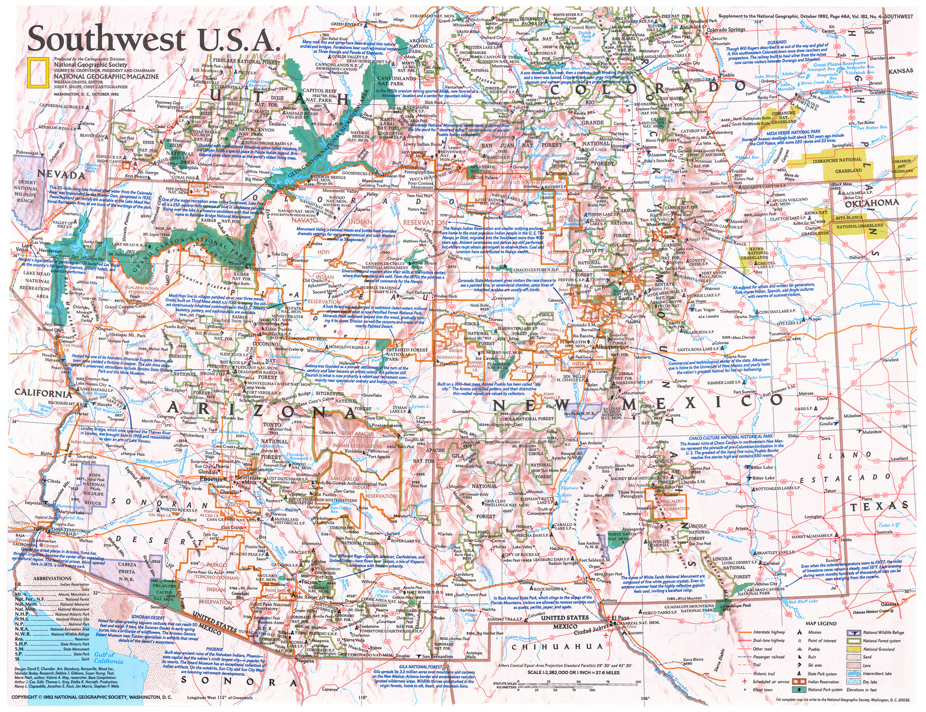
Southwest U.S.A.
-
Map/Doc
95946
-
Collection
General Map Collection
-
Object Dates
1992 (Publication Date)
-
People and Organizations
National Geographic Society (Publisher)
Mark Lambert (Donor)
-
Height x Width
15.8 x 20.5 inches
40.1 x 52.1 cm
-
Medium
paper, print
-
Comments
For research only. Donated by Mark Lambert in August, 2020. See 95945 for recto.
Related maps
The Land of Open Sky - Southwest U.S.A.

The Land of Open Sky - Southwest U.S.A.
Size 20.2 x 15.6 inches
Map/Doc 95945
Part of: General Map Collection
Map of Orange County

Print $20.00
- Digital $50.00
Map of Orange County
1886
Size 17.1 x 17.6 inches
Map/Doc 3931
Reeves County Rolled Sketch 30

Print $20.00
- Digital $50.00
Reeves County Rolled Sketch 30
1988
Size 18.4 x 24.4 inches
Map/Doc 7499
Map of Anderson County

Print $20.00
- Digital $50.00
Map of Anderson County
1879
Size 18.9 x 23.5 inches
Map/Doc 3229
Wichita Falls, Wichita County, Texas

Print $20.00
- Digital $50.00
Wichita Falls, Wichita County, Texas
Size 32.0 x 22.6 inches
Map/Doc 96791
Webb County Rolled Sketch 39

Print $20.00
- Digital $50.00
Webb County Rolled Sketch 39
1941
Size 21.3 x 18.4 inches
Map/Doc 8194
King County Working Sketch 15

Print $40.00
- Digital $50.00
King County Working Sketch 15
1979
Size 41.6 x 60.4 inches
Map/Doc 70179
Texas 1971 Official State Highway Map

Digital $50.00
Texas 1971 Official State Highway Map
Size 27.9 x 36.3 inches
Map/Doc 94315
Presidio County Rolled Sketch 22

Print $20.00
- Digital $50.00
Presidio County Rolled Sketch 22
1885
Size 37.7 x 28.7 inches
Map/Doc 7331
Map of Caldwell County

Print $20.00
- Digital $50.00
Map of Caldwell County
1871
Size 16.9 x 19.8 inches
Map/Doc 4590
Marion County Working Sketch 39

Print $20.00
- Digital $50.00
Marion County Working Sketch 39
1991
Size 20.8 x 19.2 inches
Map/Doc 70815
Colorado County Sketch File 10

Print $48.00
- Digital $50.00
Colorado County Sketch File 10
1872
Size 9.2 x 7.9 inches
Map/Doc 18929
Hale County Sketch File 11

Print $8.00
- Digital $50.00
Hale County Sketch File 11
1899
Size 11.1 x 8.5 inches
Map/Doc 24739
You may also like
Tyler County Working Sketch 25

Print $20.00
- Digital $50.00
Tyler County Working Sketch 25
1909
Size 29.8 x 26.7 inches
Map/Doc 69495
[Survey 321, Double Lakes Area Northwest of Tahoka]
![89962, [Survey 321, Double Lakes Area Northwest of Tahoka], Twichell Survey Records](https://historictexasmaps.com/wmedia_w700/maps/89962-1.tif.jpg)
Print $20.00
- Digital $50.00
[Survey 321, Double Lakes Area Northwest of Tahoka]
Size 41.3 x 43.0 inches
Map/Doc 89962
Kimble County Rolled Sketch 27

Print $20.00
- Digital $50.00
Kimble County Rolled Sketch 27
1963
Size 23.9 x 39.4 inches
Map/Doc 6517
Bandera County Working Sketch 21

Print $20.00
- Digital $50.00
Bandera County Working Sketch 21
1948
Size 21.1 x 16.7 inches
Map/Doc 67617
Right of Way and Track Map International & Gt Northern Ry. operated by the International & Gt. Northern Ry. Co., San Antonio Division

Print $40.00
- Digital $50.00
Right of Way and Track Map International & Gt Northern Ry. operated by the International & Gt. Northern Ry. Co., San Antonio Division
1917
Size 25.5 x 57.8 inches
Map/Doc 64789
[University Lands Blocks 16-20]
![91628, [University Lands Blocks 16-20], Twichell Survey Records](https://historictexasmaps.com/wmedia_w700/maps/91628-1.tif.jpg)
Print $3.00
- Digital $50.00
[University Lands Blocks 16-20]
Size 14.5 x 11.2 inches
Map/Doc 91628
Cooke County Working Sketch 7

Print $20.00
- Digital $50.00
Cooke County Working Sketch 7
1939
Size 25.1 x 33.7 inches
Map/Doc 68244
Flight Mission No. DQO-8K, Frame 7, Galveston County

Print $20.00
- Digital $50.00
Flight Mission No. DQO-8K, Frame 7, Galveston County
1952
Size 18.7 x 22.4 inches
Map/Doc 85130
Brazoria County Sketch File 2

Print $6.00
- Digital $50.00
Brazoria County Sketch File 2
Size 8.0 x 3.3 inches
Map/Doc 14920
Map of Brazoria County

Print $20.00
- Digital $50.00
Map of Brazoria County
1883
Size 26.8 x 25.6 inches
Map/Doc 861
Flight Mission No. CUG-2P, Frame 83, Kleberg County

Print $20.00
- Digital $50.00
Flight Mission No. CUG-2P, Frame 83, Kleberg County
1956
Size 18.5 x 22.3 inches
Map/Doc 86215
General Highway Map, San Patricio County, Texas

Print $20.00
General Highway Map, San Patricio County, Texas
1961
Size 18.1 x 24.5 inches
Map/Doc 79647