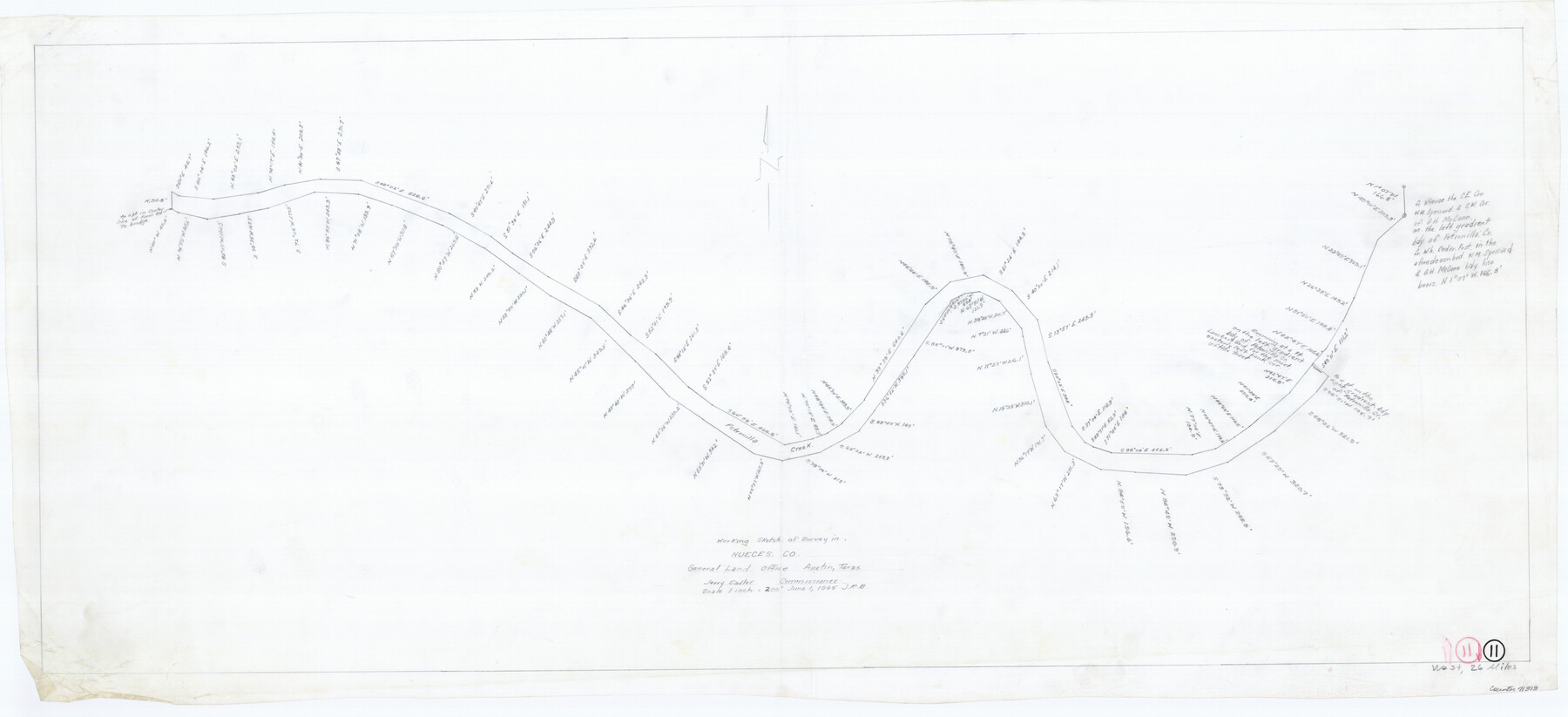
Nueces County Working Sketch 11
-
Map/Doc
71313
-
Collection
General Map Collection
-
Object Dates
6/1/1965 (Creation Date)
-
Counties
Nueces
-
Subjects
Surveying Working Sketch
-
Height x Width
20.2 x 44.1 inches
51.3 x 112.0 cm
-
Scale
1" = 200 feet
Part of: General Map Collection
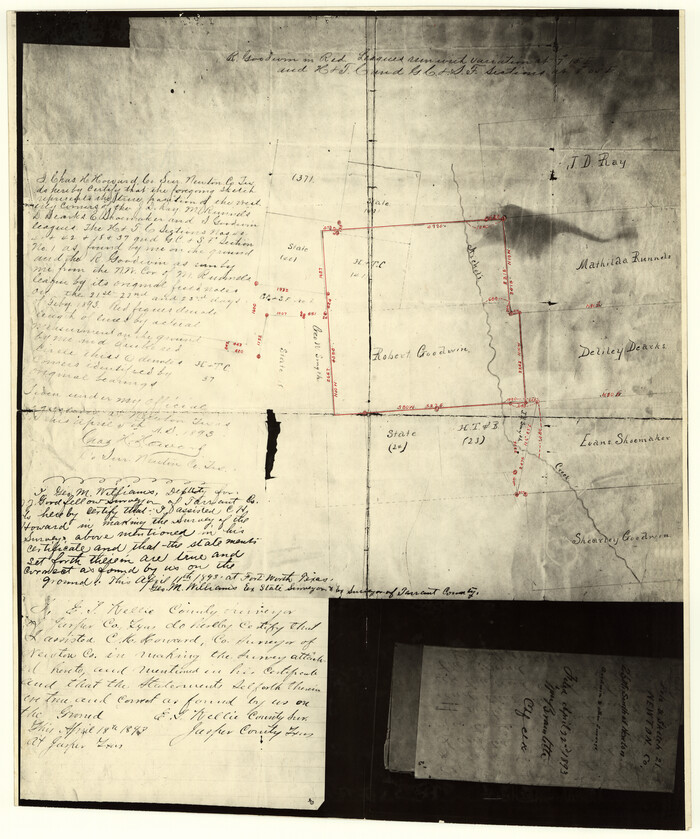
Newton County Rolled Sketch 25
Print $20.00
- Digital $50.00
Newton County Rolled Sketch 25
1893
Size 22.4 x 18.7 inches
Map/Doc 6853
Cooke County Working Sketch 11

Print $20.00
- Digital $50.00
Cooke County Working Sketch 11
1940
Size 42.6 x 28.2 inches
Map/Doc 68248
Parker County Working Sketch 3

Print $20.00
- Digital $50.00
Parker County Working Sketch 3
1941
Map/Doc 71453

Webb County Sketch File 57

Print $20.00
- Digital $50.00
Webb County Sketch File 57
1942
Size 34.0 x 17.7 inches
Map/Doc 12652
Deaf Smith County Boundary File 1

Print $124.00
- Digital $50.00
Deaf Smith County Boundary File 1
Size 14.1 x 8.6 inches
Map/Doc 52372
Foard County Sketch File 1

Print $6.00
- Digital $50.00
Foard County Sketch File 1
Size 10.0 x 9.5 inches
Map/Doc 22804
Crockett County Rolled Sketch 81

Print $20.00
- Digital $50.00
Crockett County Rolled Sketch 81
1958
Size 20.6 x 24.5 inches
Map/Doc 5621
Natural Heritage of Texas

Print $40.00
- Digital $50.00
Natural Heritage of Texas
1986
Size 54.3 x 56.0 inches
Map/Doc 10786
Maps of Gulf Intracoastal Waterway, Texas - Sabine River to the Rio Grande and connecting waterways including ship channels

Print $20.00
- Digital $50.00
Maps of Gulf Intracoastal Waterway, Texas - Sabine River to the Rio Grande and connecting waterways including ship channels
1966
Size 14.4 x 20.6 inches
Map/Doc 61996
McLennan County Sketch File 1b

Print $4.00
- Digital $50.00
McLennan County Sketch File 1b
Size 8.3 x 8.1 inches
Map/Doc 31228
Moore County Sketch File 13

Print $24.00
- Digital $50.00
Moore County Sketch File 13
1919
Size 7.0 x 8.7 inches
Map/Doc 31949
You may also like
[Surveys in the Harris District at Clear Lake]
![276, [Surveys in the Harris District at Clear Lake], General Map Collection](https://historictexasmaps.com/wmedia_w700/maps/276-1.tif.jpg)
Print $2.00
- Digital $50.00
[Surveys in the Harris District at Clear Lake]
1840
Size 6.7 x 10.5 inches
Map/Doc 276
Hays County Sketch File AB

Print $16.00
- Digital $50.00
Hays County Sketch File AB
1891
Size 6.3 x 8.7 inches
Map/Doc 26189
Trinity County Working Sketch 19

Print $20.00
- Digital $50.00
Trinity County Working Sketch 19
1982
Size 14.7 x 11.1 inches
Map/Doc 69468
[Surveys just south of Runnels County School Land Survey No. 3]
![91552, [Surveys just south of Runnels County School Land Survey No. 3], Twichell Survey Records](https://historictexasmaps.com/wmedia_w700/maps/91552-1.tif.jpg)
Print $20.00
- Digital $50.00
[Surveys just south of Runnels County School Land Survey No. 3]
1926
Size 19.4 x 13.1 inches
Map/Doc 91552
Flight Mission No. DCL-6C, Frame 118, Kenedy County

Print $20.00
- Digital $50.00
Flight Mission No. DCL-6C, Frame 118, Kenedy County
1943
Size 18.6 x 22.4 inches
Map/Doc 85948
Calhoun County Rolled Sketch 30

Print $20.00
- Digital $50.00
Calhoun County Rolled Sketch 30
1974
Size 18.6 x 27.6 inches
Map/Doc 5495
Stephens County Working Sketch 33

Print $20.00
- Digital $50.00
Stephens County Working Sketch 33
1978
Size 31.1 x 30.8 inches
Map/Doc 63976
Flight Mission No. CRK-5P, Frame 160, Refugio County

Print $20.00
- Digital $50.00
Flight Mission No. CRK-5P, Frame 160, Refugio County
1956
Size 18.6 x 22.4 inches
Map/Doc 86941
Kendall County Sketch File 24

Print $8.00
- Digital $50.00
Kendall County Sketch File 24
Size 13.1 x 8.7 inches
Map/Doc 28718
Umbarger in Randall County, Texas

Print $20.00
- Digital $50.00
Umbarger in Randall County, Texas
1905
Size 31.9 x 30.8 inches
Map/Doc 92158
[Capitol Lands in Oldham and Deaf Smith Counties]
![91482, [Capitol Lands in Oldham and Deaf Smith Counties], Twichell Survey Records](https://historictexasmaps.com/wmedia_w700/maps/91482-1.tif.jpg)
Print $20.00
- Digital $50.00
[Capitol Lands in Oldham and Deaf Smith Counties]
Size 23.2 x 25.8 inches
Map/Doc 91482
Coke County Sketch File 33

Print $20.00
- Digital $50.00
Coke County Sketch File 33
Size 22.0 x 26.6 inches
Map/Doc 11115