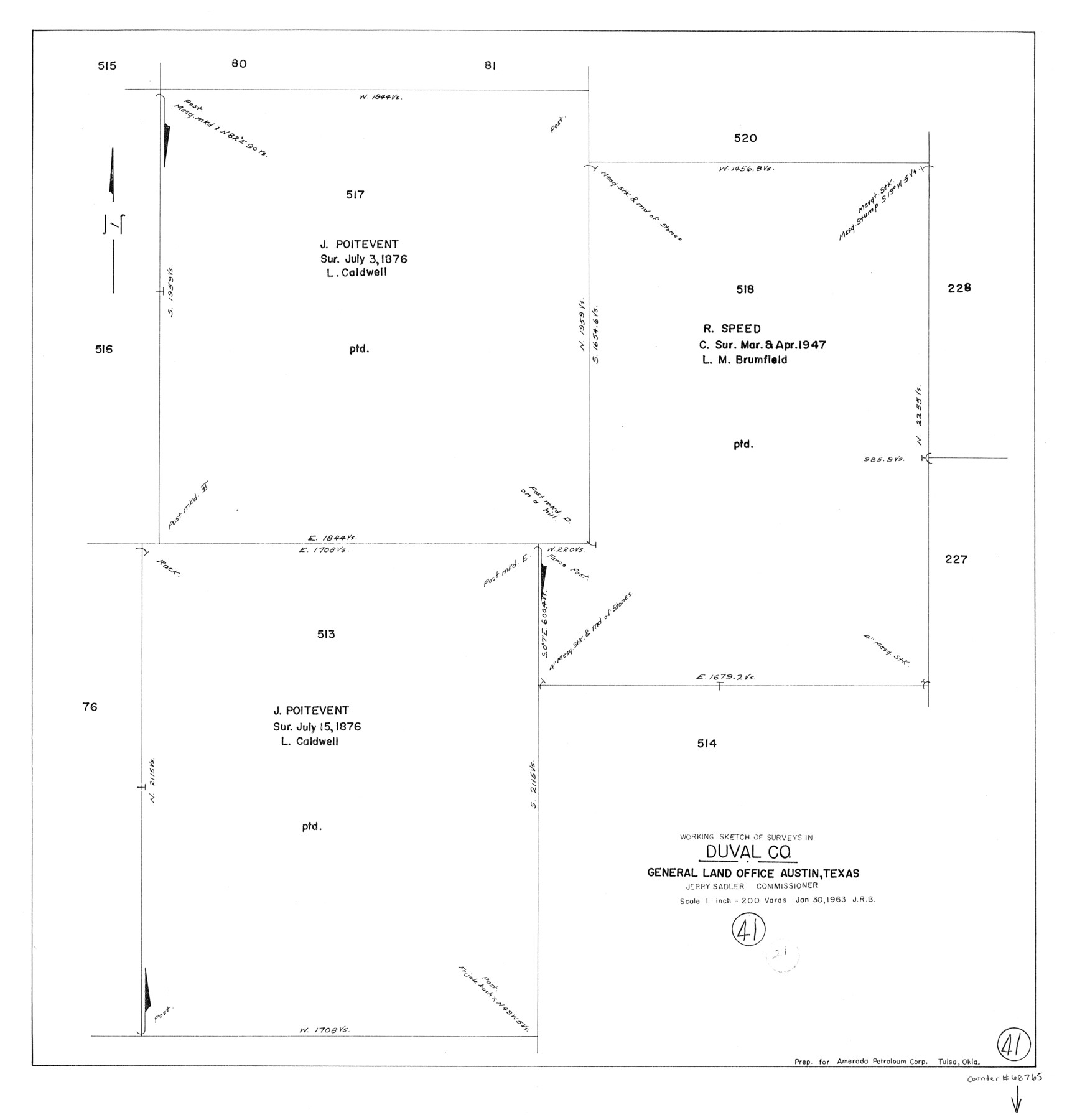
Duval County Working Sketch 41
-
Map/Doc
68765
-
Collection
General Map Collection
-
Object Dates
1/30/1963 (Creation Date)
-
Counties
Duval
-
Subjects
Surveying Working Sketch
-
Height x Width
24.1 x 22.9 inches
61.2 x 58.2 cm
-
Scale
1" = 200 varas
Part of: General Map Collection
Hutchinson County Sketch File 18

Print $28.00
- Digital $50.00
Hutchinson County Sketch File 18
1909
Size 6.7 x 8.3 inches
Map/Doc 27220
Crockett County Rolled Sketch 28

Print $20.00
- Digital $50.00
Crockett County Rolled Sketch 28
1884
Size 42.5 x 25.8 inches
Map/Doc 5587
Hardin County Sketch File 45

Print $2.00
- Digital $50.00
Hardin County Sketch File 45
Size 8.3 x 6.2 inches
Map/Doc 25195
McLennan County Sketch File 7b

Print $6.00
- Digital $50.00
McLennan County Sketch File 7b
1857
Size 8.0 x 10.1 inches
Map/Doc 31248
Galveston County Boundary File 32a

Print $10.00
- Digital $50.00
Galveston County Boundary File 32a
Size 11.4 x 8.9 inches
Map/Doc 53666
Map of the County of Cameron, Texas

Print $40.00
- Digital $50.00
Map of the County of Cameron, Texas
1884
Size 54.7 x 34.5 inches
Map/Doc 3141
Pecos County Rolled Sketch 72

Print $30.00
- Digital $50.00
Pecos County Rolled Sketch 72
1934
Size 35.8 x 45.1 inches
Map/Doc 9704
Right of Way and Track Map for The Missouri, Kansas & Texas Railway of Texas

Print $40.00
- Digital $50.00
Right of Way and Track Map for The Missouri, Kansas & Texas Railway of Texas
1918
Size 25.9 x 56.0 inches
Map/Doc 64527
Robertson County Rolled Sketch 5

Print $20.00
- Digital $50.00
Robertson County Rolled Sketch 5
1976
Size 34.1 x 36.4 inches
Map/Doc 9864
Shelby County Sketch File 26

Print $4.00
- Digital $50.00
Shelby County Sketch File 26
Size 8.1 x 8.1 inches
Map/Doc 36660
Flight Mission No. CGI-3N, Frame 69, Cameron County

Print $20.00
- Digital $50.00
Flight Mission No. CGI-3N, Frame 69, Cameron County
1954
Size 18.4 x 22.1 inches
Map/Doc 84563
Book of Photostatic Copies of Plats for Texas and Pacific Ry. Co. Lands

Digital $50.00
Book of Photostatic Copies of Plats for Texas and Pacific Ry. Co. Lands
Map/Doc 2222
You may also like

Coke County Rolled Sketch 16A

Print $20.00
- Digital $50.00
Coke County Rolled Sketch 16A
Size 32.3 x 30.4 inches
Map/Doc 5518

Edwards County Working Sketch 47

Print $20.00
- Digital $50.00
Edwards County Working Sketch 47
1950
Size 37.9 x 24.1 inches
Map/Doc 68923
[Sketch between Collingsworth County and Oklahoma]
![89673, [Sketch between Collingsworth County and Oklahoma], Twichell Survey Records](https://historictexasmaps.com/wmedia_w700/maps/89673-1.tif.jpg)
Print $40.00
- Digital $50.00
[Sketch between Collingsworth County and Oklahoma]
Size 63.2 x 9.1 inches
Map/Doc 89673
Val Verde County Rolled Sketch 72

Print $20.00
- Digital $50.00
Val Verde County Rolled Sketch 72
Size 15.2 x 28.5 inches
Map/Doc 8134
Upton County Rolled Sketch 59A

Print $20.00
- Digital $50.00
Upton County Rolled Sketch 59A
Size 35.7 x 45.9 inches
Map/Doc 76423
Gaines County Working Sketch 12

Print $20.00
- Digital $50.00
Gaines County Working Sketch 12
1954
Size 27.1 x 37.0 inches
Map/Doc 69312
Wilbarger County Aerial Photograph Index Sheet 1

Print $20.00
- Digital $50.00
Wilbarger County Aerial Photograph Index Sheet 1
1950
Size 22.4 x 18.9 inches
Map/Doc 83750
Gulf, Texas & Western Railway

Print $40.00
- Digital $50.00
Gulf, Texas & Western Railway
1909
Size 18.7 x 103.5 inches
Map/Doc 64431
Flight Mission No. DCL-7C, Frame 38, Kenedy County

Print $20.00
- Digital $50.00
Flight Mission No. DCL-7C, Frame 38, Kenedy County
1943
Size 15.4 x 15.1 inches
Map/Doc 86026
Van Zandt County Sketch File 14

Print $4.00
- Digital $50.00
Van Zandt County Sketch File 14
1858
Size 7.9 x 8.1 inches
Map/Doc 39404