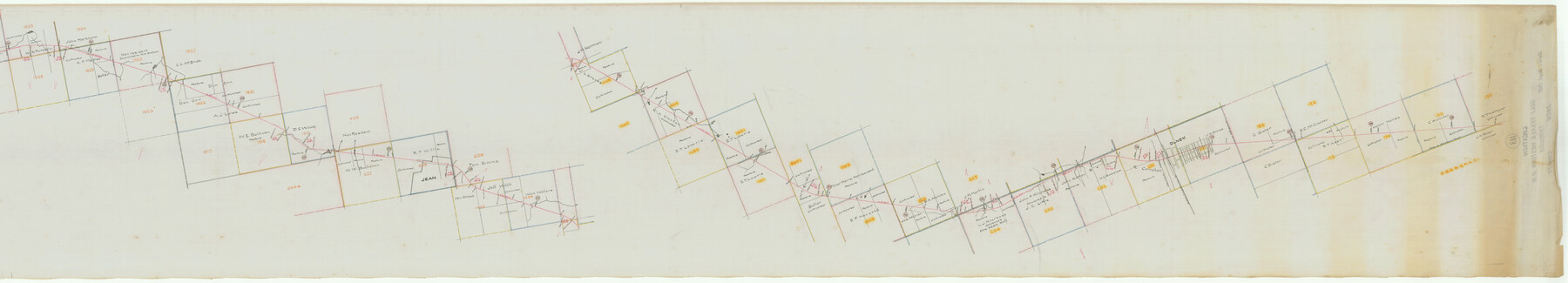
Gulf, Texas & Western Railway
Z-2-113
-
Map/Doc
64431
-
Collection
General Map Collection
-
Object Dates
1909 (Creation Date)
-
People and Organizations
Will S. Clark (Draftsman)
-
Counties
Jack Young
-
Subjects
Railroads
-
Height x Width
18.7 x 103.5 inches
47.5 x 262.9 cm
-
Scale
1 in. = 1000 ft.
-
Comments
Map of location from Jacksboro West through Young County, Mile 96 to Mile 157. Segment 2; see counter no. 64430 for segment 1.
-
Features
GT&W
Olney
WF&S
Olney & Seymour Road
Related maps
Gulf, Texas & Western Railway

Print $40.00
- Digital $50.00
Gulf, Texas & Western Railway
1909
Size 18.5 x 121.0 inches
Map/Doc 64430
Part of: General Map Collection
Jones County Sketch File 1

Print $20.00
- Digital $50.00
Jones County Sketch File 1
1857
Size 17.8 x 30.3 inches
Map/Doc 11894
Kerr County Working Sketch 8

Print $20.00
- Digital $50.00
Kerr County Working Sketch 8
1948
Size 18.1 x 23.6 inches
Map/Doc 70039
Cherokee County Sketch File 19

Print $4.00
- Digital $50.00
Cherokee County Sketch File 19
1876
Size 8.2 x 8.4 inches
Map/Doc 18161

Stephens County Sketch File 19

Print $14.00
- Digital $50.00
Stephens County Sketch File 19
1919
Size 8.9 x 7.8 inches
Map/Doc 37077
Flight Mission No. BRE-2P, Frame 131, Nueces County

Print $20.00
- Digital $50.00
Flight Mission No. BRE-2P, Frame 131, Nueces County
1956
Size 18.6 x 22.5 inches
Map/Doc 86804
Blanco County Rolled Sketch 23

Print $20.00
- Digital $50.00
Blanco County Rolled Sketch 23
2019
Size 24.1 x 35.7 inches
Map/Doc 97346
Runnels County Rolled Sketch 34

Print $20.00
- Digital $50.00
Runnels County Rolled Sketch 34
Size 30.1 x 35.1 inches
Map/Doc 7522
Travis County Rolled Sketch 30

Print $20.00
- Digital $50.00
Travis County Rolled Sketch 30
1943
Size 26.5 x 25.6 inches
Map/Doc 8032
Flight Mission No. CGI-1N, Frame 184, Cameron County

Print $20.00
- Digital $50.00
Flight Mission No. CGI-1N, Frame 184, Cameron County
1955
Size 18.5 x 22.2 inches
Map/Doc 84519
Harris County Working Sketch 25

Print $20.00
- Digital $50.00
Harris County Working Sketch 25
1928
Size 26.7 x 24.3 inches
Map/Doc 65917
Galveston County Sketch File 9

Print $6.00
- Digital $50.00
Galveston County Sketch File 9
1866
Size 10.1 x 8.1 inches
Map/Doc 23369
You may also like

Frio County Rolled Sketch 15

Print $20.00
- Digital $50.00
Frio County Rolled Sketch 15
1949
Size 26.1 x 39.0 inches
Map/Doc 5922
Liberty County Rolled Sketch JP2

Print $40.00
- Digital $50.00
Liberty County Rolled Sketch JP2
1935
Size 51.8 x 12.8 inches
Map/Doc 10663
Blanco County Sketch File 34

Print $4.00
- Digital $50.00
Blanco County Sketch File 34
1879
Size 12.7 x 8.2 inches
Map/Doc 14637
Plan of the City of Austin

Print $40.00
- Digital $50.00
Plan of the City of Austin
1840
Size 56.2 x 42.0 inches
Map/Doc 4837
Packery Channel

Print $2.00
- Digital $50.00
Packery Channel
1971
Size 9.2 x 9.1 inches
Map/Doc 2998
Floyd County Sketch File 29

Print $20.00
- Digital $50.00
Floyd County Sketch File 29
Size 17.0 x 16.5 inches
Map/Doc 11488
Val Verde County Sketch File A3

Print $20.00
- Digital $50.00
Val Verde County Sketch File A3
1917
Size 25.6 x 42.3 inches
Map/Doc 10418
Austin Map and Street Guide [Verso]
![94163, Austin Map and Street Guide [Verso], General Map Collection](https://historictexasmaps.com/wmedia_w700/maps/94163.tif.jpg)
Austin Map and Street Guide [Verso]
1986
Size 35.5 x 22.8 inches
Map/Doc 94163
A sketch of the San Antonio River collected from the Land Office surveys

Print $20.00
- Digital $50.00
A sketch of the San Antonio River collected from the Land Office surveys
1853
Size 27.2 x 16.3 inches
Map/Doc 73010
San Augustine County Working Sketch 9

Print $20.00
- Digital $50.00
San Augustine County Working Sketch 9
1935
Size 41.2 x 39.7 inches
Map/Doc 63696
[Blk. B, Secs. 111-114 and vicinity]
![90340, [Blk. B, Secs. 111-114 and vicinity], Twichell Survey Records](https://historictexasmaps.com/wmedia_w700/maps/90340-1.tif.jpg)
Print $20.00
- Digital $50.00
[Blk. B, Secs. 111-114 and vicinity]
Size 31.3 x 38.7 inches
Map/Doc 90340