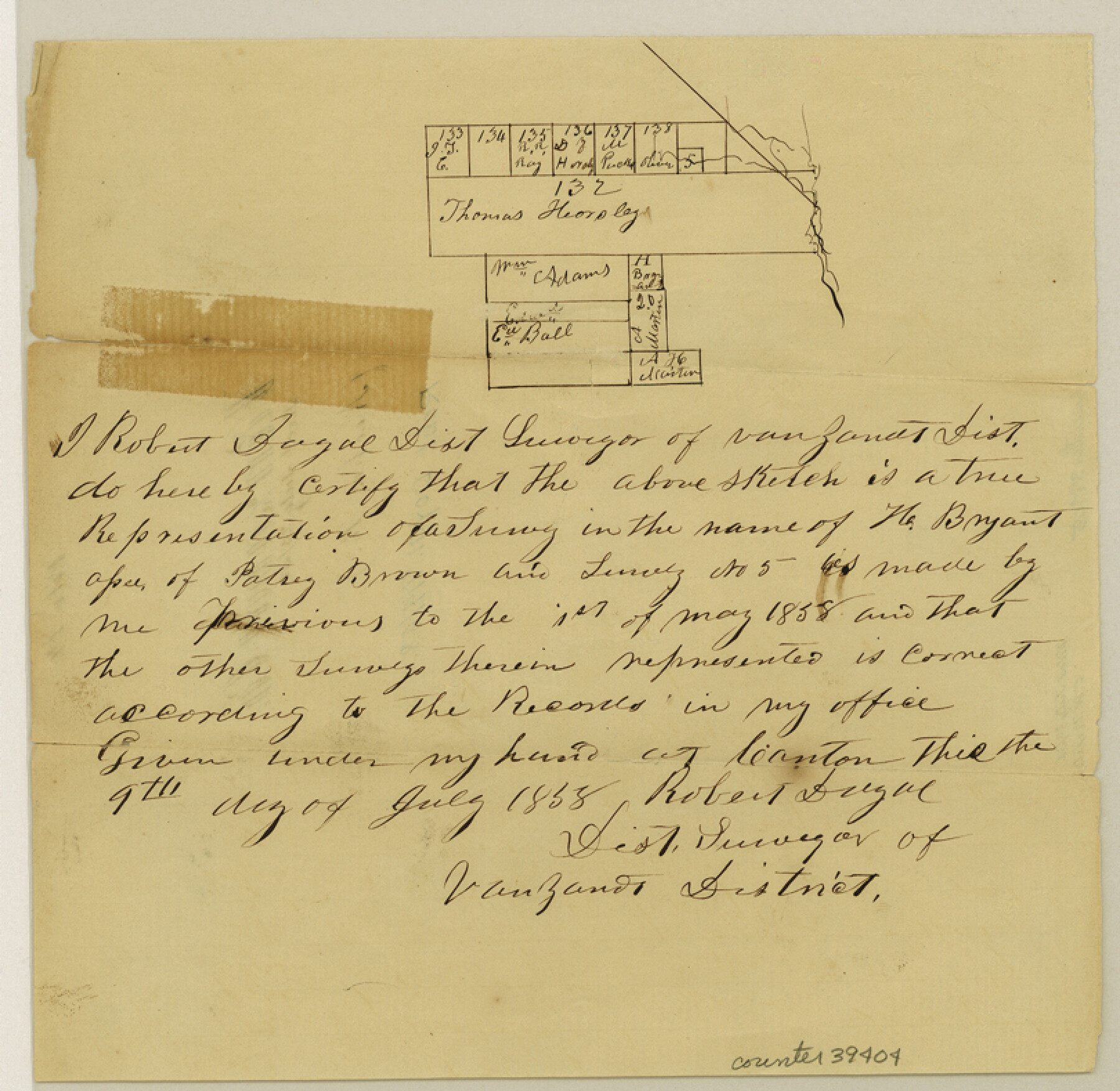
Van Zandt County Sketch File 14
[Sketch of surveys on the west side of the Neches River in the southeast part of the county]
- 
                          Map/Doc
39404
 - 
                            Collection
General Map Collection
 - 
                            Object Dates
7/9/1858 (Creation Date)
7/23/1858 (File Date)
 - 
                            People and Organizations
Robert Doyal (Surveyor/Engineer)
 - 
                            Counties
Van Zandt
 - 
                            Subjects
Surveying Sketch File
 - 
                            Height x Width
7.9 x 8.1 inches
20.1 x 20.6 cm
 - 
                            Medium
paper, manuscript
 - 
                            Features
Neches River
 
Part of: General Map Collection
            Map of Hill County


                                            Print $20.00                    
                                             -                         Digital $50.00                                    
                Map of Hill County
1862
Size 22.1 x 24.7 inches
                                Map/Doc 3671
            
            Van Zandt County Sketch File 32


                                            Print $4.00                    
                                             -                         Digital $50.00                                    
                Van Zandt County Sketch File 32
1860
Size 12.2 x 7.9 inches
                                Map/Doc 39465
            
            Flight Mission No. DQO-7K, Frame 83, Galveston County


                                            Print $20.00                    
                                             -                         Digital $50.00                                    
                Flight Mission No. DQO-7K, Frame 83, Galveston County
1952
Size 18.8 x 22.5 inches
                                Map/Doc 85110
            
            Floyd County Working Sketch 8


                                            Print $20.00                    
                                             -                         Digital $50.00                                    
                Floyd County Working Sketch 8
1931
Size 20.8 x 15.9 inches
                                Map/Doc 69187
            
            Winkler County Sketch File 5


                                            Print $16.00                    
                                             -                         Digital $50.00                                    
                Winkler County Sketch File 5
1900
Size 11.2 x 8.7 inches
                                Map/Doc 40467
            
            Travis County Working Sketch 27


                                            Print $20.00                    
                                             -                         Digital $50.00                                    
                Travis County Working Sketch 27
1951
Size 17.6 x 31.6 inches
                                Map/Doc 69411
            
            Brewster County Rolled Sketch C


                                            Print $40.00                    
                                             -                         Digital $50.00                                    
                Brewster County Rolled Sketch C
Size 39.0 x 71.8 inches
                                Map/Doc 8466
            
            Sabine River, Merrill Lake Sheet


                                            Print $20.00                    
                                             -                         Digital $50.00                                    
                Sabine River, Merrill Lake Sheet
1933
Size 26.4 x 43.6 inches
                                Map/Doc 65137
            
            Denton County Sketch File 34


                                            Print $4.00                    
                                             -                         Digital $50.00                                    
                Denton County Sketch File 34
1880
Size 8.9 x 5.4 inches
                                Map/Doc 20764
            
            Starr County Sketch File 35


                                            Print $24.00                    
                                             -                         Digital $50.00                                    
                Starr County Sketch File 35
1939
Size 14.3 x 8.8 inches
                                Map/Doc 36974
            
            Coleman County Sketch File 2


                                            Print $2.00                    
                                             -                         Digital $50.00                                    
                Coleman County Sketch File 2
Size 8.4 x 3.3 inches
                                Map/Doc 18669
            You may also like
            Guadalupe County


                                            Print $20.00                    
                                             -                         Digital $50.00                                    
                Guadalupe County
1877
Size 21.5 x 21.4 inches
                                Map/Doc 3608
            
            Galveston County NRC Article 33.136 Sketch 7


                                            Print $20.00                    
                                             -                         Digital $50.00                                    
                Galveston County NRC Article 33.136 Sketch 7
2001
Size 23.7 x 37.2 inches
                                Map/Doc 61589
            
            Baylor County Boundary File 5


                                            Print $56.00                    
                                             -                         Digital $50.00                                    
                Baylor County Boundary File 5
Size 8.1 x 62.3 inches
                                Map/Doc 50392
            
            Irion County Sketch File 10


                                            Print $20.00                    
                                             -                         Digital $50.00                                    
                Irion County Sketch File 10
1936
Size 16.7 x 30.5 inches
                                Map/Doc 11825
            
            Runnels County Sketch File 29


                                            Print $20.00                    
                                    
                Runnels County Sketch File 29
1950
Size 23.8 x 18.0 inches
                                Map/Doc 12261
            
            Floyd County Boundary File 2


                                            Print $53.00                    
                                             -                         Digital $50.00                                    
                Floyd County Boundary File 2
Size 8.9 x 4.2 inches
                                Map/Doc 53462
            
            Lavaca County Working Sketch 22


                                            Print $20.00                    
                                             -                         Digital $50.00                                    
                Lavaca County Working Sketch 22
1983
Size 39.6 x 36.4 inches
                                Map/Doc 70375
            
            Yoakum County Working Sketch Graphic Index


                                            Print $20.00                    
                                             -                         Digital $50.00                                    
                Yoakum County Working Sketch Graphic Index
1932
Size 44.7 x 33.1 inches
                                Map/Doc 76747
            
            Map of the Lands Surveyed by the Memphis, El Paso & Pacific R.R. Company


                                            Print $20.00                    
                                             -                         Digital $50.00                                    
                Map of the Lands Surveyed by the Memphis, El Paso & Pacific R.R. Company
1859
Size 15.8 x 19.0 inches
                                Map/Doc 4844
            
            Haskell County Rolled Sketch 16


                                            Print $20.00                    
                                             -                         Digital $50.00                                    
                Haskell County Rolled Sketch 16
1991
Size 45.3 x 39.4 inches
                                Map/Doc 9148
            
            Descripción y Mapa de la Nueva Provincia, poblada de Bárbaros, situada en la Costa del Seno Mexicano, desde el puerto de Tampico hasta la Provincia de Texas


            Descripción y Mapa de la Nueva Provincia, poblada de Bárbaros, situada en la Costa del Seno Mexicano, desde el puerto de Tampico hasta la Provincia de Texas
1744
Size 32.0 x 29.1 inches
                                Map/Doc 94558
            
            Map of Central Europe engraved to illustrate Mitchell's new intermediate geography


                                            Print $20.00                    
                                             -                         Digital $50.00                                    
                Map of Central Europe engraved to illustrate Mitchell's new intermediate geography
1885
Size 9.0 x 12.2 inches
                                Map/Doc 93528