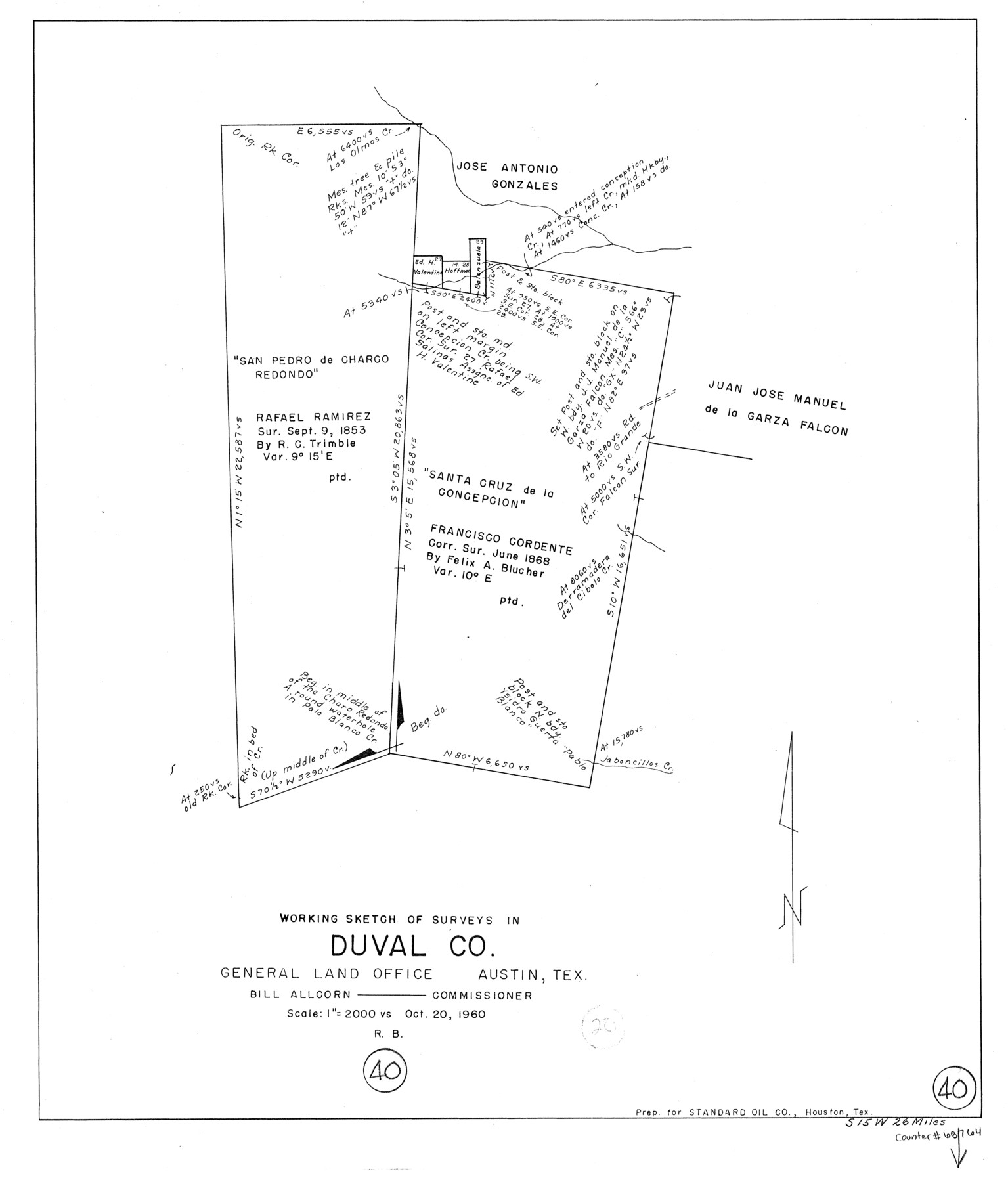
Duval County Working Sketch 40
-
Map/Doc
68764
-
Collection
General Map Collection
-
Object Dates
10/20/1960 (Creation Date)
-
People and Organizations
Roy Buckholts (Draftsman)
-
Counties
Duval
-
Subjects
Surveying Working Sketch
-
Height x Width
19.5 x 16.6 inches
49.5 x 42.2 cm
-
Scale
1" = 2000 varas
Part of: General Map Collection
Liberty County Sketch File 56

Print $20.00
- Digital $50.00
Liberty County Sketch File 56
Size 11.9 x 18.7 inches
Map/Doc 11996
Plan B, Part 3rd Shewing that portion of the boundary between Texas and the United States, included between Logan's Ferry on the River Sabine and the intersection of the 32nd degree of N. Latitude with the western bank of the said river

Print $20.00
- Digital $50.00
Plan B, Part 3rd Shewing that portion of the boundary between Texas and the United States, included between Logan's Ferry on the River Sabine and the intersection of the 32nd degree of N. Latitude with the western bank of the said river
1842
Size 19.4 x 27.2 inches
Map/Doc 65411
San Jacinto County Sketch File 18

Print $20.00
San Jacinto County Sketch File 18
1934
Size 43.6 x 18.1 inches
Map/Doc 10599
Brazoria County Working Sketch 35

Print $40.00
- Digital $50.00
Brazoria County Working Sketch 35
1981
Size 43.5 x 66.2 inches
Map/Doc 67520
Galveston County NRC Article 33.136 Sketch 92

Print $62.00
Galveston County NRC Article 33.136 Sketch 92
2021
Map/Doc 97179
Sutton County Rolled Sketch 58

Print $20.00
- Digital $50.00
Sutton County Rolled Sketch 58
Size 31.2 x 15.9 inches
Map/Doc 7896
Hale County Boundary File 2

Print $4.00
- Digital $50.00
Hale County Boundary File 2
Size 10.9 x 8.8 inches
Map/Doc 54044
San Augustine County Rolled Sketch 1

Print $20.00
- Digital $50.00
San Augustine County Rolled Sketch 1
Size 16.6 x 13.8 inches
Map/Doc 7552
Jefferson County Sketch File 40

Print $16.00
- Digital $50.00
Jefferson County Sketch File 40
1947
Size 12.3 x 7.9 inches
Map/Doc 28228
Harris County Rolled Sketch WHW

Print $20.00
- Digital $50.00
Harris County Rolled Sketch WHW
1930
Size 20.7 x 41.6 inches
Map/Doc 6466
Map of the Houston & Great Northern Railroad

Print $40.00
- Digital $50.00
Map of the Houston & Great Northern Railroad
1871
Size 26.6 x 48.4 inches
Map/Doc 64472

You may also like
Williamson County Sketch File 3

Print $24.00
- Digital $50.00
Williamson County Sketch File 3
1853
Size 13.0 x 8.2 inches
Map/Doc 40301
[Nathaniel H. Cochran Survey and Vicinity]
![91497, [Nathaniel H. Cochran Survey and Vicinity], Twichell Survey Records](https://historictexasmaps.com/wmedia_w700/maps/91497-1.tif.jpg)
Print $20.00
- Digital $50.00
[Nathaniel H. Cochran Survey and Vicinity]
Size 25.5 x 18.8 inches
Map/Doc 91497
Denton County Texas

Print $20.00
- Digital $50.00
Denton County Texas
1896
Size 18.4 x 31.6 inches
Map/Doc 4530
Jack County Working Sketch 23

Print $20.00
- Digital $50.00
Jack County Working Sketch 23
2006
Size 18.4 x 22.0 inches
Map/Doc 83606
Foard County Sketch File 9

Print $20.00
- Digital $50.00
Foard County Sketch File 9
1882
Size 19.7 x 17.1 inches
Map/Doc 11492
Nueces County Rolled Sketch 68A

Print $165.00
- Digital $50.00
Nueces County Rolled Sketch 68A
1980
Size 9.8 x 15.0 inches
Map/Doc 47898
Presidio County Sketch File P2

Print $6.00
- Digital $50.00
Presidio County Sketch File P2
Size 14.3 x 8.9 inches
Map/Doc 34558
Map showing eight tidal areas in Oso Bay and Oso Creek, Nueces County, Texas offered for Mineral Development

Print $20.00
- Digital $50.00
Map showing eight tidal areas in Oso Bay and Oso Creek, Nueces County, Texas offered for Mineral Development
1936
Size 17.9 x 29.7 inches
Map/Doc 2067
Calhoun County Rolled Sketch 14

Print $20.00
- Digital $50.00
Calhoun County Rolled Sketch 14
Size 21.9 x 40.1 inches
Map/Doc 5459
Bastrop County Rolled Sketch 4

Print $40.00
- Digital $50.00
Bastrop County Rolled Sketch 4
1999
Size 130.2 x 30.8 inches
Map/Doc 8443
Bird's Eye View of the City of San Antonio, Bexar County, Texas

Print $20.00
Bird's Eye View of the City of San Antonio, Bexar County, Texas
1873
Size 23.9 x 29.6 inches
Map/Doc 89203
Brewster County Working Sketch 35

Print $20.00
- Digital $50.00
Brewster County Working Sketch 35
1943
Size 21.0 x 19.4 inches
Map/Doc 67569