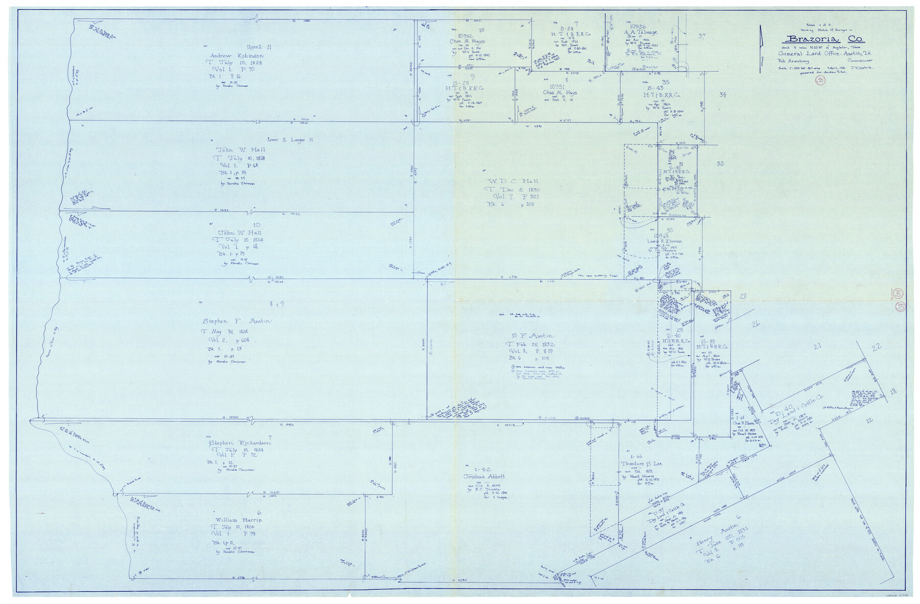
Brazoria County Working Sketch 35
-
Map/Doc
67520
-
Collection
General Map Collection
-
Object Dates
4/9/1981 (Creation Date)
-
People and Organizations
Bob Armstrong (GLO Commissioner)
Joan Kilpatrick (Draftsman)
-
Counties
Brazoria
-
Subjects
Surveying Working Sketch
-
Height x Width
43.5 x 66.2 inches
110.5 x 168.2 cm
-
Scale
1" = 360 varas
-
Comments
Surveys located about nine miles North 10 degrees West of Angleton, Texas.
Part of: General Map Collection
Mexico or New Spain in which the Motions of Cortes may be traced

Print $20.00
- Digital $50.00
Mexico or New Spain in which the Motions of Cortes may be traced
1795
Size 14.5 x 16.5 inches
Map/Doc 93650

Sutton County Sketch File 9

Print $6.00
- Digital $50.00
Sutton County Sketch File 9
1893
Size 14.2 x 8.5 inches
Map/Doc 37367
Brewster County Rolled Sketch 19A

Print $20.00
- Digital $50.00
Brewster County Rolled Sketch 19A
1881
Size 31.5 x 38.6 inches
Map/Doc 8471
Military Reconnaissance [showing forts along Rio Grande near Matamoros]
![72911, Military Reconnaissance [showing forts along Rio Grande near Matamoros], General Map Collection](https://historictexasmaps.com/wmedia_w700/maps/72911.tif.jpg)
Print $20.00
- Digital $50.00
Military Reconnaissance [showing forts along Rio Grande near Matamoros]
1846
Size 18.2 x 27.2 inches
Map/Doc 72911
Galveston County NRC Article 33.136 Sketch 47

Print $24.00
- Digital $50.00
Galveston County NRC Article 33.136 Sketch 47
2006
Size 18.3 x 24.4 inches
Map/Doc 87504
Tom Green County Rolled Sketch 18

Print $20.00
- Digital $50.00
Tom Green County Rolled Sketch 18
Size 15.7 x 23.8 inches
Map/Doc 8001
Zavala County Working Sketch 25

Print $20.00
- Digital $50.00
Zavala County Working Sketch 25
1984
Size 37.7 x 30.0 inches
Map/Doc 62100
Bandera County Working Sketch Graphic Index

Print $40.00
- Digital $50.00
Bandera County Working Sketch Graphic Index
1947
Size 33.5 x 53.8 inches
Map/Doc 76461
Boundary between Republic of Texas and US from Logan's Ferry to Red River - surveyed in 1841

Print $20.00
- Digital $50.00
Boundary between Republic of Texas and US from Logan's Ferry to Red River - surveyed in 1841
1841
Size 19.4 x 27.4 inches
Map/Doc 65415
Bandera County

Print $40.00
- Digital $50.00
Bandera County
1904
Size 30.7 x 61.0 inches
Map/Doc 3274
Nueces County Working Sketch 6

Print $20.00
- Digital $50.00
Nueces County Working Sketch 6
1987
Size 33.7 x 42.9 inches
Map/Doc 71308
You may also like
Flight Mission No. DCL-4C, Frame 95, Kenedy County

Print $20.00
- Digital $50.00
Flight Mission No. DCL-4C, Frame 95, Kenedy County
1943
Size 18.7 x 22.3 inches
Map/Doc 85816
Bexar County Sketch File 25

Print $4.00
- Digital $50.00
Bexar County Sketch File 25
1860
Size 8.9 x 8.7 inches
Map/Doc 14486
Hudspeth County Working Sketch 46

Print $20.00
- Digital $50.00
Hudspeth County Working Sketch 46
1983
Size 47.0 x 43.0 inches
Map/Doc 66331
Map of Matagorda County

Print $20.00
- Digital $50.00
Map of Matagorda County
1865
Size 26.9 x 25.0 inches
Map/Doc 3842
General Highway Map, Williamson County, Texas

Print $20.00
General Highway Map, Williamson County, Texas
1940
Size 24.7 x 18.4 inches
Map/Doc 79281
Refugio County Sketch File 1

Print $8.00
- Digital $50.00
Refugio County Sketch File 1
1846
Size 12.6 x 7.8 inches
Map/Doc 35235
Location of the Southern Kansas Railway of Texas, Carson County, Texas

Print $40.00
- Digital $50.00
Location of the Southern Kansas Railway of Texas, Carson County, Texas
1887
Size 20.5 x 84.3 inches
Map/Doc 64035
Polk County Working Sketch 21

Print $20.00
- Digital $50.00
Polk County Working Sketch 21
1953
Size 22.6 x 24.2 inches
Map/Doc 71636
Jack County Working Sketch 19

Print $20.00
- Digital $50.00
Jack County Working Sketch 19
1989
Size 21.5 x 29.4 inches
Map/Doc 66445
Johnson County Boundary File 1

Print $66.00
- Digital $50.00
Johnson County Boundary File 1
Size 14.1 x 8.5 inches
Map/Doc 55551
Wichita County Boundary File 1

Print $11.00
- Digital $50.00
Wichita County Boundary File 1
Size 14.4 x 8.8 inches
Map/Doc 59895
L. Wright's Subdivision of the Southwest Corner of Survey Number 6, D4]
![90785, L. Wright's Subdivision of the Southwest Corner of Survey Number 6, D4], Twichell Survey Records](https://historictexasmaps.com/wmedia_w700/maps/90785-1.tif.jpg)
Print $20.00
- Digital $50.00
L. Wright's Subdivision of the Southwest Corner of Survey Number 6, D4]
1906
Size 14.1 x 18.5 inches
Map/Doc 90785