San Jacinto County Sketch File 18
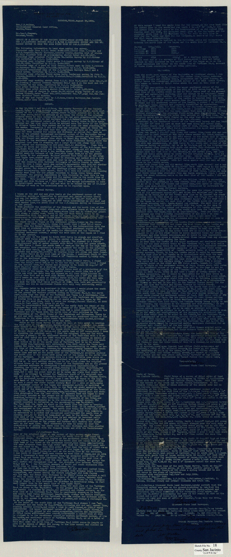
Report on a survey in San Jacinto County, Texas around the W.G. Logan, the J.D. Martinez surveys nos. 3 & 4, the E. Sanderson survey and the Wm. Hardin survey to show the area filed upon by Jas. R. Chapman
-
Map/Doc
10599
-
Collection
General Map Collection
-
Object Dates
8/30/1934 (Creation Date)
9/22/1934 (File Date)
-
People and Organizations
J.S. Boyles (Surveyor/Engineer)
-
Counties
San Jacinto
-
Subjects
Surveying Sketch File
-
Height x Width
43.6 x 18.1 inches
110.7 x 46.0 cm
-
Medium
blueprint/diazo
-
Comments
See San Jacinto County Sketch File 17 (10598) for sketch.
-
Features
Big Creek
Mussels Shoals
Trinity River
Spring Branch Draw
Related maps
San Jacinto County Sketch File 17

Print $40.00
San Jacinto County Sketch File 17
1934
Size 60.1 x 26.3 inches
Map/Doc 10598
Part of: General Map Collection
Flight Mission No. CRC-2R, Frame 199, Chambers County

Print $20.00
- Digital $50.00
Flight Mission No. CRC-2R, Frame 199, Chambers County
1956
Size 18.6 x 22.4 inches
Map/Doc 84777
Lipscomb County Rolled Sketch 3

Print $20.00
- Digital $50.00
Lipscomb County Rolled Sketch 3
1886
Size 24.2 x 31.0 inches
Map/Doc 6629
Lynn County Sketch File 13

Print $18.00
- Digital $50.00
Lynn County Sketch File 13
1903
Size 10.6 x 8.1 inches
Map/Doc 30482
Milam County Working Sketch 10

Print $20.00
- Digital $50.00
Milam County Working Sketch 10
1986
Size 25.5 x 34.6 inches
Map/Doc 71025
Haskell County Boundary File 7

Print $40.00
- Digital $50.00
Haskell County Boundary File 7
Size 3.6 x 38.5 inches
Map/Doc 54584
Flight Mission No. DQN-5K, Frame 31, Calhoun County

Print $20.00
- Digital $50.00
Flight Mission No. DQN-5K, Frame 31, Calhoun County
1953
Size 18.5 x 22.1 inches
Map/Doc 84382
McCulloch County Sketch File 3

Print $12.00
- Digital $50.00
McCulloch County Sketch File 3
1893
Size 11.1 x 8.5 inches
Map/Doc 31169
Railroad Track Map, H&TCRRCo., Falls County, Texas

Print $4.00
- Digital $50.00
Railroad Track Map, H&TCRRCo., Falls County, Texas
1918
Size 11.6 x 18.6 inches
Map/Doc 62852
[Part of Bexar District]
![1958, [Part of Bexar District], General Map Collection](https://historictexasmaps.com/wmedia_w700/maps/1958-1.tif.jpg)
Print $20.00
- Digital $50.00
[Part of Bexar District]
1847
Size 40.9 x 27.8 inches
Map/Doc 1958
Presidio County Rolled Sketch 63

Print $20.00
- Digital $50.00
Presidio County Rolled Sketch 63
Size 21.6 x 21.3 inches
Map/Doc 7355
Culberson County Working Sketch 88

Print $20.00
- Digital $50.00
Culberson County Working Sketch 88
1983
Size 32.8 x 37.1 inches
Map/Doc 68542
Hopkins County Sketch File 29

Print $4.00
- Digital $50.00
Hopkins County Sketch File 29
1873
Size 10.0 x 8.1 inches
Map/Doc 26740
You may also like
Hale County Sketch File 5-5a

Print $30.00
- Digital $50.00
Hale County Sketch File 5-5a
1891
Size 17.7 x 38.3 inches
Map/Doc 10467
The Republic County of Gonzales. May 24, 1838

Print $20.00
The Republic County of Gonzales. May 24, 1838
2020
Size 14.7 x 21.7 inches
Map/Doc 96156
Gillespie County Sketch File 7

Print $4.00
- Digital $50.00
Gillespie County Sketch File 7
1872
Size 7.7 x 7.3 inches
Map/Doc 24141
Tyler County Sketch File 27

Print $6.00
- Digital $50.00
Tyler County Sketch File 27
1956
Size 14.5 x 8.8 inches
Map/Doc 38696
Flight Mission No. CRC-5R, Frame 43, Chambers County

Print $20.00
- Digital $50.00
Flight Mission No. CRC-5R, Frame 43, Chambers County
1956
Size 18.6 x 22.3 inches
Map/Doc 84962
Flight Mission No. BRA-16M, Frame 164, Jefferson County

Print $20.00
- Digital $50.00
Flight Mission No. BRA-16M, Frame 164, Jefferson County
1953
Size 18.7 x 22.3 inches
Map/Doc 85762
Current Miscellaneous File 35

Print $10.00
- Digital $50.00
Current Miscellaneous File 35
Size 14.2 x 8.7 inches
Map/Doc 73947
Calhoun County Rolled Sketch 30

Print $20.00
- Digital $50.00
Calhoun County Rolled Sketch 30
1974
Size 18.6 x 27.2 inches
Map/Doc 5497
Map of Hyde Park

Print $20.00
- Digital $50.00
Map of Hyde Park
1895
Size 41.7 x 28.8 inches
Map/Doc 76206
Burleson County Sketch File 8

Print $6.00
- Digital $50.00
Burleson County Sketch File 8
Size 8.7 x 5.3 inches
Map/Doc 16654
Comanche County Sketch File 22

Print $4.00
- Digital $50.00
Comanche County Sketch File 22
1873
Size 15.2 x 9.2 inches
Map/Doc 19106
Texas Official Highway Travel Map

Digital $50.00
Texas Official Highway Travel Map
Size 27.3 x 36.3 inches
Map/Doc 94306