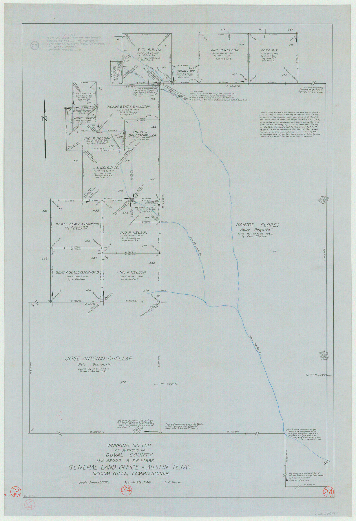
Duval County Working Sketch 24
-
Map/Doc
68748
-
Collection
General Map Collection
-
Object Dates
3/25/1944 (Creation Date)
-
People and Organizations
Otto G. Kurio (Draftsman)
-
Counties
Duval
-
Subjects
Surveying Working Sketch
-
Height x Width
40.0 x 27.3 inches
101.6 x 69.3 cm
-
Scale
1" = 500 varas
Part of: General Map Collection
United States - Gulf Coast - Galveston to Rio Grande

Print $20.00
- Digital $50.00
United States - Gulf Coast - Galveston to Rio Grande
Size 27.9 x 18.3 inches
Map/Doc 72742
Webb County Rolled Sketch 3

Print $20.00
- Digital $50.00
Webb County Rolled Sketch 3
1884
Size 19.7 x 24.8 inches
Map/Doc 8170

Matagorda County Working Sketch 15

Print $40.00
- Digital $50.00
Matagorda County Working Sketch 15
1954
Size 49.3 x 44.5 inches
Map/Doc 70873
Crockett County Sketch File 76

Print $2.00
- Digital $50.00
Crockett County Sketch File 76
1933
Size 11.2 x 8.6 inches
Map/Doc 19876

Flight Mission No. DQN-5K, Frame 149, Calhoun County

Print $20.00
- Digital $50.00
Flight Mission No. DQN-5K, Frame 149, Calhoun County
1953
Size 18.5 x 22.2 inches
Map/Doc 84424

Reagan County Rolled Sketch 9

Print $20.00
- Digital $50.00
Reagan County Rolled Sketch 9
1937
Size 29.7 x 30.9 inches
Map/Doc 7437
Menard County Sketch File 11

Print $8.00
- Digital $50.00
Menard County Sketch File 11
1892
Size 12.8 x 8.3 inches
Map/Doc 31496
Laguna Madre, Texas from Latitude 26° 20' to 26° 27'

Print $40.00
- Digital $50.00
Laguna Madre, Texas from Latitude 26° 20' to 26° 27'
1879
Size 32.7 x 55.0 inches
Map/Doc 73498
Upton County Working Sketch 9

Print $20.00
- Digital $50.00
Upton County Working Sketch 9
1926
Size 26.0 x 15.8 inches
Map/Doc 69505
You may also like
Harris County Sketch File 90

Print $46.00
- Digital $50.00
Harris County Sketch File 90
1967
Size 12.2 x 14.4 inches
Map/Doc 25596
Brewster County Rolled Sketch K

Print $20.00
- Digital $50.00
Brewster County Rolled Sketch K
1884
Size 19.6 x 13.9 inches
Map/Doc 5321
Parker County

Print $20.00
- Digital $50.00
Parker County
1942
Size 46.7 x 37.9 inches
Map/Doc 73258
Hardin County Sketch File Q-11

Print $20.00
- Digital $50.00
Hardin County Sketch File Q-11
1937
Size 19.9 x 23.8 inches
Map/Doc 11645
Travis County Working Sketch 49

Print $20.00
- Digital $50.00
Travis County Working Sketch 49
1984
Size 33.9 x 37.2 inches
Map/Doc 69433
Bandera County

Print $40.00
- Digital $50.00
Bandera County
1947
Size 33.7 x 54.2 inches
Map/Doc 77207
Cass County Working Sketch 9

Print $20.00
- Digital $50.00
Cass County Working Sketch 9
1937
Size 28.4 x 32.7 inches
Map/Doc 67912
Reeves County Boundary File 73a

Print $16.00
- Digital $50.00
Reeves County Boundary File 73a
Size 13.3 x 8.2 inches
Map/Doc 58208
Coast Chart No. 210 Aransas Pass and Corpus Christi Bay with the coast to latitude 27° 12' Texas

Print $20.00
- Digital $50.00
Coast Chart No. 210 Aransas Pass and Corpus Christi Bay with the coast to latitude 27° 12' Texas
1887
Size 27.5 x 18.4 inches
Map/Doc 72786
[Map of Chicago, Rock Island & Texas Railway through Tarrant County, Texas]
![64412, [Map of Chicago, Rock Island & Texas Railway through Tarrant County, Texas], General Map Collection](https://historictexasmaps.com/wmedia_w700/maps/64412.tif.jpg)
Print $40.00
- Digital $50.00
[Map of Chicago, Rock Island & Texas Railway through Tarrant County, Texas]
1893
Size 22.9 x 122.0 inches
Map/Doc 64412
Val Verde County Rolled Sketch 59

Print $20.00
- Digital $50.00
Val Verde County Rolled Sketch 59
1947
Size 45.2 x 23.6 inches
Map/Doc 10078
Flight Mission No. CLL-3N, Frame 33, Willacy County

Print $20.00
- Digital $50.00
Flight Mission No. CLL-3N, Frame 33, Willacy County
1954
Size 18.6 x 22.3 inches
Map/Doc 87090