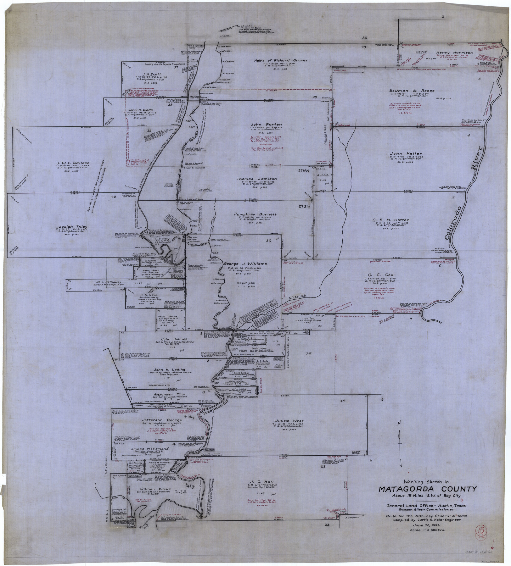
Matagorda County Working Sketch 15
-
Map/Doc
70873
-
Collection
General Map Collection
-
Object Dates
6/28/1954 (Creation Date)
-
People and Organizations
Curtis R. Hale (Draftsman)
-
Counties
Matagorda
-
Subjects
Surveying Working Sketch
-
Height x Width
49.3 x 44.5 inches
125.2 x 113.0 cm
-
Scale
1" = 600 varas
Part of: General Map Collection
Andrews County Sketch File 12

Print $8.00
- Digital $50.00
Andrews County Sketch File 12
1963
Size 11.1 x 8.5 inches
Map/Doc 12857
Knox County Working Sketch 8

Print $20.00
- Digital $50.00
Knox County Working Sketch 8
1942
Size 38.7 x 14.3 inches
Map/Doc 70250
Pecos County Working Sketch 68

Print $20.00
- Digital $50.00
Pecos County Working Sketch 68
1955
Size 41.4 x 24.0 inches
Map/Doc 71540
Flight Mission No. CGI-1N, Frame 177, Cameron County

Print $20.00
- Digital $50.00
Flight Mission No. CGI-1N, Frame 177, Cameron County
1955
Size 18.5 x 17.6 inches
Map/Doc 84512
Lavaca County Working Sketch 22

Print $20.00
- Digital $50.00
Lavaca County Working Sketch 22
1983
Size 39.6 x 36.4 inches
Map/Doc 70375
Bosque County Working Sketch 17

Print $20.00
- Digital $50.00
Bosque County Working Sketch 17
1975
Size 18.3 x 21.1 inches
Map/Doc 67450
Menard County Working Sketch Graphic Index

Print $20.00
- Digital $50.00
Menard County Working Sketch Graphic Index
1942
Size 38.4 x 41.7 inches
Map/Doc 76640
Glasscock County Sketch File 5

Print $20.00
- Digital $50.00
Glasscock County Sketch File 5
1929
Size 23.0 x 22.7 inches
Map/Doc 11561
Trinity River, Bazzette Sheet

Print $4.00
- Digital $50.00
Trinity River, Bazzette Sheet
1925
Size 28.2 x 24.9 inches
Map/Doc 65218
Railroad Track Map, T&PRRCo., Culberson County, Texas

Print $4.00
- Digital $50.00
Railroad Track Map, T&PRRCo., Culberson County, Texas
1910
Size 11.7 x 18.5 inches
Map/Doc 62825
Reeves County Sketch File 19

Print $9.00
- Digital $50.00
Reeves County Sketch File 19
1958
Size 11.3 x 8.9 inches
Map/Doc 35212
Brewster County Sketch File D-1

Print $12.00
- Digital $50.00
Brewster County Sketch File D-1
1909
Size 14.4 x 8.8 inches
Map/Doc 15740
You may also like
[Sketch for Mineral Application 1112 - Colorado River, H. E. Chambers]
![65639, [Sketch for Mineral Application 1112 - Colorado River, H. E. Chambers], General Map Collection](https://historictexasmaps.com/wmedia_w700/maps/65639.tif.jpg)
Print $20.00
- Digital $50.00
[Sketch for Mineral Application 1112 - Colorado River, H. E. Chambers]
1918
Size 17.3 x 28.3 inches
Map/Doc 65639
Flight Mission No. DQO-12K, Frame 43, Galveston County

Print $20.00
- Digital $50.00
Flight Mission No. DQO-12K, Frame 43, Galveston County
1952
Size 18.6 x 22.4 inches
Map/Doc 85233
Map of the Republic of Mexico

Print $20.00
Map of the Republic of Mexico
1882
Size 33.0 x 47.4 inches
Map/Doc 76220
Chambers County Working Sketch 4

Print $20.00
- Digital $50.00
Chambers County Working Sketch 4
1937
Size 34.0 x 31.4 inches
Map/Doc 67987
Topographical Map of the Rio Grande, Sheet No. 6

Print $20.00
- Digital $50.00
Topographical Map of the Rio Grande, Sheet No. 6
1912
Map/Doc 89530
San Patricio County NRC Article 33.136 Sketch 9

Print $82.00
San Patricio County NRC Article 33.136 Sketch 9
2022
Map/Doc 97031
Current Miscellaneous File 111

Print $8.00
- Digital $50.00
Current Miscellaneous File 111
1996
Size 11.3 x 8.7 inches
Map/Doc 74714
Montgomery County Sketch File 39

Print $4.00
- Digital $50.00
Montgomery County Sketch File 39
1941
Size 14.6 x 8.6 inches
Map/Doc 31923
Aransas County Rolled Sketch 2

Print $20.00
- Digital $50.00
Aransas County Rolled Sketch 2
1950
Size 21.4 x 24.4 inches
Map/Doc 73615
Harris County Rolled Sketch 94

Print $20.00
- Digital $50.00
Harris County Rolled Sketch 94
1985
Size 33.8 x 18.4 inches
Map/Doc 6133
Moore County Working Sketch 9

Print $20.00
- Digital $50.00
Moore County Working Sketch 9
1950
Size 38.5 x 31.8 inches
Map/Doc 71191
Outer Continental Shelf Leasing Maps (Louisiana Offshore Operations)

Print $20.00
- Digital $50.00
Outer Continental Shelf Leasing Maps (Louisiana Offshore Operations)
1959
Size 17.7 x 13.9 inches
Map/Doc 76108