Reagan County Rolled Sketch 9
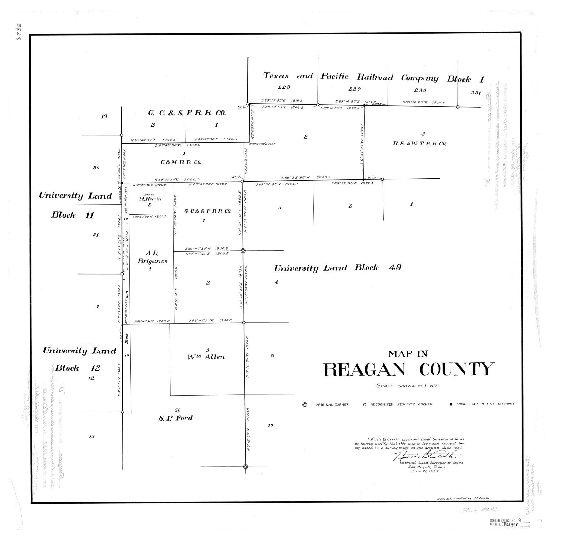
Map in Reagan County [showing area between University Land Blocks 11 and 12 and University Land Block 49]
-
Map/Doc
7437
-
Collection
General Map Collection
-
Object Dates
1937/6/26 (Creation Date)
1937 (Survey Date)
1937/6/30 (File Date)
-
People and Organizations
Norris B. Creath (Surveyor/Engineer)
J.A. Conklin (Draftsman)
J.A. Conklin (Compiler)
-
Counties
Reagan
-
Subjects
Surveying Rolled Sketch
-
Height x Width
29.7 x 30.9 inches
75.4 x 78.5 cm
-
Scale
1" = 500 varas
Part of: General Map Collection
Flight Mission No. BRE-2P, Frame 10, Nueces County

Print $20.00
- Digital $50.00
Flight Mission No. BRE-2P, Frame 10, Nueces County
1956
Size 17.9 x 21.5 inches
Map/Doc 86719
Controlled Mosaic by Jack Amman Photogrammetric Engineers, Inc - Sheet 42

Print $20.00
- Digital $50.00
Controlled Mosaic by Jack Amman Photogrammetric Engineers, Inc - Sheet 42
1954
Size 20.0 x 24.0 inches
Map/Doc 83499
Jeff Davis County Sketch File 15

Print $20.00
- Digital $50.00
Jeff Davis County Sketch File 15
1883
Size 28.5 x 18.9 inches
Map/Doc 11859
Rains County Sketch File 10

Print $20.00
- Digital $50.00
Rains County Sketch File 10
Size 20.9 x 15.7 inches
Map/Doc 12203
Medina County Rolled Sketch 14

Print $20.00
- Digital $50.00
Medina County Rolled Sketch 14
1980
Size 29.2 x 32.0 inches
Map/Doc 6748
Fisher County Working Sketch 13

Print $20.00
- Digital $50.00
Fisher County Working Sketch 13
1956
Size 29.8 x 32.7 inches
Map/Doc 69147
Jackson County Aerial Photograph Index Sheet 6

Print $20.00
- Digital $50.00
Jackson County Aerial Photograph Index Sheet 6
1956
Size 21.2 x 15.7 inches
Map/Doc 83705
Fisher County Rolled Sketch 5

Print $20.00
- Digital $50.00
Fisher County Rolled Sketch 5
1961
Size 39.1 x 33.7 inches
Map/Doc 8890

Map of Shelby County

Print $20.00
- Digital $50.00
Map of Shelby County
1863
Size 18.6 x 22.3 inches
Map/Doc 4031
Robertson Co.

Print $20.00
- Digital $50.00
Robertson Co.
1889
Size 43.7 x 39.9 inches
Map/Doc 63003
History of the Geography of Texas

Print $40.00
- Digital $50.00
History of the Geography of Texas
1897
Size 70.7 x 52.9 inches
Map/Doc 3095
You may also like
Nueces County Rolled Sketch 123 A-D

Print $10.00
- Digital $50.00
Nueces County Rolled Sketch 123 A-D
1997
Size 11.3 x 8.8 inches
Map/Doc 41586
Willacy County Working Sketch Graphic Index

Print $20.00
- Digital $50.00
Willacy County Working Sketch Graphic Index
1921
Size 32.8 x 32.7 inches
Map/Doc 76741
Crockett County Working Sketch 62

Print $40.00
- Digital $50.00
Crockett County Working Sketch 62
1956
Size 121.8 x 37.1 inches
Map/Doc 68395
Travis County Appraisal District Plat Map 2_0018

Print $20.00
- Digital $50.00
Travis County Appraisal District Plat Map 2_0018
Size 21.6 x 26.5 inches
Map/Doc 94208
Comanche County Sketch File 16

Print $6.00
- Digital $50.00
Comanche County Sketch File 16
Size 11.8 x 11.5 inches
Map/Doc 19082
Flight Mission No. CRC-6R, Frame 13, Chambers County

Print $20.00
- Digital $50.00
Flight Mission No. CRC-6R, Frame 13, Chambers County
1956
Size 18.6 x 22.3 inches
Map/Doc 84967
Menard County Working Sketch 10

Print $20.00
- Digital $50.00
Menard County Working Sketch 10
1938
Size 21.8 x 18.5 inches
Map/Doc 70957
Jackson County Boundary File 2

Print $22.00
- Digital $50.00
Jackson County Boundary File 2
Size 8.6 x 4.1 inches
Map/Doc 55437
Webb County Rolled Sketch 41

Print $20.00
- Digital $50.00
Webb County Rolled Sketch 41
1941
Size 25.0 x 18.0 inches
Map/Doc 8196
El Paso County Sketch File 41

Print $6.00
- Digital $50.00
El Paso County Sketch File 41
1994
Size 11.4 x 8.8 inches
Map/Doc 22238
Victoria County Sketch File 9

Print $8.00
- Digital $50.00
Victoria County Sketch File 9
1938
Size 14.3 x 8.8 inches
Map/Doc 39530
Dallam County Sketch File 4

Print $20.00
- Digital $50.00
Dallam County Sketch File 4
Size 27.7 x 8.5 inches
Map/Doc 11279