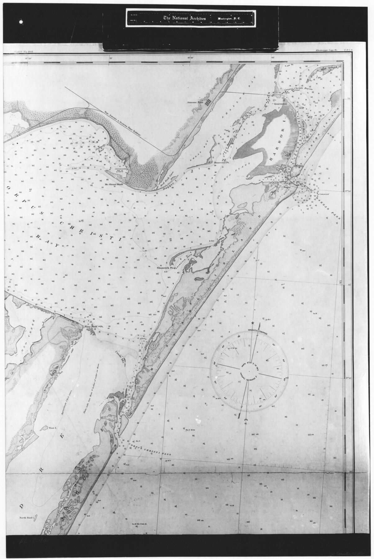
Coast Chart No. 210 Aransas Pass and Corpus Christi Bay with the coast to latitude 27° 12' Texas
RL-2-9a
-
Map/Doc
72786
-
Collection
General Map Collection
-
Object Dates
1887 (Creation Date)
-
People and Organizations
Coast and Geodetic Survey (Publisher)
-
Counties
Nueces
-
Subjects
Nautical Charts
-
Height x Width
27.5 x 18.4 inches
69.9 x 46.7 cm
-
Comments
B/W photostat copy from National Archives in multiple pieces.
Part of: General Map Collection
Harris County Texas

Print $20.00
- Digital $50.00
Harris County Texas
1908
Size 19.7 x 24.7 inches
Map/Doc 11652
Rand, McNally and Co.'s Texas and Indian Territory

Print $20.00
- Digital $50.00
Rand, McNally and Co.'s Texas and Indian Territory
1883
Size 24.3 x 18.6 inches
Map/Doc 4331
Hutchinson County

Print $20.00
- Digital $50.00
Hutchinson County
1922
Size 45.6 x 38.8 inches
Map/Doc 1863
Calhoun County Rolled Sketch 13

Print $20.00
- Digital $50.00
Calhoun County Rolled Sketch 13
1948
Size 43.0 x 41.0 inches
Map/Doc 8547
Flight Mission No. DIX-5P, Frame 148, Aransas County

Print $20.00
- Digital $50.00
Flight Mission No. DIX-5P, Frame 148, Aransas County
1956
Size 17.9 x 18.0 inches
Map/Doc 83810
Borden County Rolled Sketch 7

Print $20.00
- Digital $50.00
Borden County Rolled Sketch 7
Size 16.9 x 18.5 inches
Map/Doc 5157
Flight Mission No. CUG-1P, Frame 169, Kleberg County

Print $20.00
- Digital $50.00
Flight Mission No. CUG-1P, Frame 169, Kleberg County
1956
Size 18.6 x 22.4 inches
Map/Doc 86176
Polk County Working Sketch 34

Print $20.00
- Digital $50.00
Polk County Working Sketch 34
1961
Size 41.3 x 42.0 inches
Map/Doc 71651
Pecos County Working Sketch 124

Print $40.00
- Digital $50.00
Pecos County Working Sketch 124
1974
Size 57.9 x 38.2 inches
Map/Doc 71597
East Part of Brewster Co.

Print $40.00
- Digital $50.00
East Part of Brewster Co.
1952
Size 49.5 x 31.1 inches
Map/Doc 95436
Crane County Working Sketch 17

Print $40.00
- Digital $50.00
Crane County Working Sketch 17
1957
Size 121.8 x 50.0 inches
Map/Doc 68294
Edwards County Working Sketch 3

Print $20.00
- Digital $50.00
Edwards County Working Sketch 3
Size 22.6 x 18.3 inches
Map/Doc 68879
You may also like
[Portion of a sketch showing S.F. 7265]
![90386, [Portion of a sketch showing S.F. 7265], Twichell Survey Records](https://historictexasmaps.com/wmedia_w700/maps/90386-1.tif.jpg)
Print $2.00
- Digital $50.00
[Portion of a sketch showing S.F. 7265]
Size 13.3 x 9.1 inches
Map/Doc 90386
Fort Bend County Working Sketch 23

Print $20.00
- Digital $50.00
Fort Bend County Working Sketch 23
1978
Size 37.2 x 29.8 inches
Map/Doc 69229
Walker County Working Sketch 13

Print $20.00
- Digital $50.00
Walker County Working Sketch 13
1950
Size 18.0 x 16.6 inches
Map/Doc 72293
Llano County Boundary File 1a

Print $44.00
- Digital $50.00
Llano County Boundary File 1a
Size 13.2 x 8.1 inches
Map/Doc 56430
Travis County Rolled Sketch 27

Print $20.00
- Digital $50.00
Travis County Rolled Sketch 27
1945
Size 23.5 x 17.8 inches
Map/Doc 8029
Midland County Sketch File D

Print $42.00
- Digital $50.00
Midland County Sketch File D
1901
Size 32.6 x 18.4 inches
Map/Doc 12089
[Surveys along Verde and Bandera Creeks]
![289, [Surveys along Verde and Bandera Creeks], General Map Collection](https://historictexasmaps.com/wmedia_w700/maps/289.tif.jpg)
Print $2.00
- Digital $50.00
[Surveys along Verde and Bandera Creeks]
1846
Size 10.0 x 8.0 inches
Map/Doc 289
Map of Mitchell County, Texas

Print $20.00
Map of Mitchell County, Texas
1890
Size 23.4 x 18.9 inches
Map/Doc 88980
Presidio County Working Sketch 46

Print $40.00
- Digital $50.00
Presidio County Working Sketch 46
1947
Size 36.8 x 59.0 inches
Map/Doc 71723
Rachford's Complete Map of the City of Beaumont

Print $20.00
- Digital $50.00
Rachford's Complete Map of the City of Beaumont
1897
Size 33.4 x 23.6 inches
Map/Doc 97355
Hutchinson County Working Sketch 36

Print $20.00
- Digital $50.00
Hutchinson County Working Sketch 36
1978
Size 27.2 x 22.4 inches
Map/Doc 66396
General Highway Map, Trinity County, Texas

Print $20.00
General Highway Map, Trinity County, Texas
1940
Size 18.4 x 24.9 inches
Map/Doc 79263