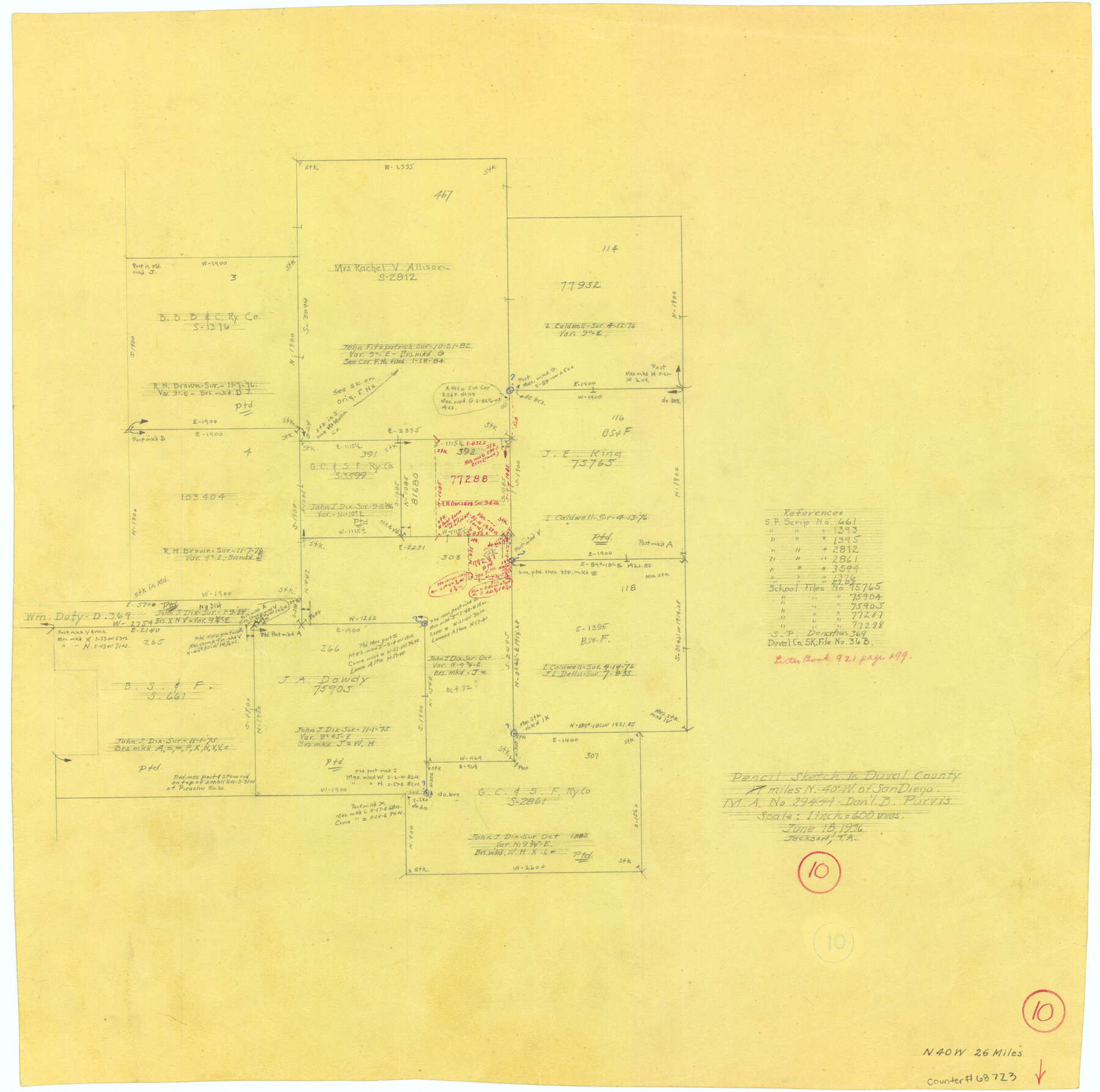
Duval County Working Sketch 10
-
Map/Doc
68723
-
Collection
General Map Collection
-
Object Dates
6/18/1936 (Creation Date)
-
People and Organizations
T.A. Jackson (Draftsman)
-
Counties
Duval
-
Subjects
Surveying Working Sketch
-
Height x Width
20.1 x 20.3 inches
51.1 x 51.6 cm
-
Scale
1" = 600 varas
Part of: General Map Collection
New Map of Texas prepared and published for the Bureau of Immigration of the State of Texas

Print $20.00
- Digital $50.00
New Map of Texas prepared and published for the Bureau of Immigration of the State of Texas
1875
Size 15.8 x 18.3 inches
Map/Doc 93626
Map of the European Settlements in Mexico or New Spain and the West Indies

Print $20.00
- Digital $50.00
Map of the European Settlements in Mexico or New Spain and the West Indies
1783
Size 14.1 x 21.1 inches
Map/Doc 93643
Flight Mission No. CRC-3R, Frame 43, Chambers County

Print $20.00
- Digital $50.00
Flight Mission No. CRC-3R, Frame 43, Chambers County
1956
Size 18.5 x 22.3 inches
Map/Doc 84816
Map of Brown County

Print $40.00
- Digital $50.00
Map of Brown County
1886
Size 48.9 x 41.6 inches
Map/Doc 3342
Flight Mission No. DAG-23K, Frame 165, Matagorda County

Print $20.00
- Digital $50.00
Flight Mission No. DAG-23K, Frame 165, Matagorda County
1953
Size 17.0 x 19.0 inches
Map/Doc 86503
Stephens County

Print $20.00
- Digital $50.00
Stephens County
1940
Size 42.4 x 40.7 inches
Map/Doc 95644
[Aransas Wildlife Refuge]
![2081, [Aransas Wildlife Refuge], General Map Collection](https://historictexasmaps.com/wmedia_w700/maps/2081.tif.jpg)
Print $40.00
- Digital $50.00
[Aransas Wildlife Refuge]
1965
Size 55.6 x 42.9 inches
Map/Doc 2081
Taylor County

Print $20.00
- Digital $50.00
Taylor County
1934
Size 44.4 x 38.9 inches
Map/Doc 73299
Anderson County Working Sketch 41

Print $20.00
- Digital $50.00
Anderson County Working Sketch 41
1956
Size 19.2 x 20.5 inches
Map/Doc 67041
Gaines County Working Sketch 25

Print $20.00
- Digital $50.00
Gaines County Working Sketch 25
1983
Size 37.5 x 38.4 inches
Map/Doc 69325
San Saba County Sketch File 9

Print $22.00
- Digital $50.00
San Saba County Sketch File 9
1883
Size 12.3 x 13.7 inches
Map/Doc 36433
Ochiltree County Boundary File 1c

Print $2.00
- Digital $50.00
Ochiltree County Boundary File 1c
Size 10.6 x 8.1 inches
Map/Doc 57674
You may also like
Aransas County Sketch File 28

Print $16.00
- Digital $50.00
Aransas County Sketch File 28
1973
Size 11.3 x 8.8 inches
Map/Doc 13226
Midland County

Print $20.00
- Digital $50.00
Midland County
1930
Size 45.7 x 39.6 inches
Map/Doc 66930
Crockett County Sketch File 89

Print $40.00
- Digital $50.00
Crockett County Sketch File 89
1958
Size 12.7 x 13.5 inches
Map/Doc 19916
Oldham County Rolled Sketch 10

Print $20.00
- Digital $50.00
Oldham County Rolled Sketch 10
Size 22.0 x 13.3 inches
Map/Doc 7176
Floyd County Boundary File 4a

Print $40.00
- Digital $50.00
Floyd County Boundary File 4a
Size 12.2 x 35.8 inches
Map/Doc 53496
Falls County Sketch File 2

Print $4.00
- Digital $50.00
Falls County Sketch File 2
1854
Size 13.1 x 8.3 inches
Map/Doc 22332
Flight Mission No. DQO-8K, Frame 67, Galveston County

Print $20.00
- Digital $50.00
Flight Mission No. DQO-8K, Frame 67, Galveston County
1952
Size 18.9 x 22.4 inches
Map/Doc 85171
R. S. Coon's Blue Creek Ranch, Moore County, Texas

Print $20.00
- Digital $50.00
R. S. Coon's Blue Creek Ranch, Moore County, Texas
Size 15.8 x 15.7 inches
Map/Doc 91487
Denton County Sketch File 9

Print $6.00
- Digital $50.00
Denton County Sketch File 9
1856
Size 8.6 x 13.3 inches
Map/Doc 20705
Dimmit County Working Sketch 3

Print $20.00
- Digital $50.00
Dimmit County Working Sketch 3
1911
Size 16.5 x 22.5 inches
Map/Doc 68664
Culberson County Rolled Sketch 52

Print $20.00
- Digital $50.00
Culberson County Rolled Sketch 52
Size 19.1 x 24.7 inches
Map/Doc 5672
Fannin County Rolled Sketch 18F

Print $2.00
- Digital $50.00
Fannin County Rolled Sketch 18F
Size 8.9 x 8.2 inches
Map/Doc 5873